Maroochydore
Maroochydore is a coastal town and suburb of the Sunshine Coast Region, Queensland, Australia.[2][3] At the 2016 census the suburb recorded a population of 16,800.[1]
| Maroochydore Sunshine Coast, Queensland | |||||||||||||||
|---|---|---|---|---|---|---|---|---|---|---|---|---|---|---|---|
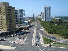
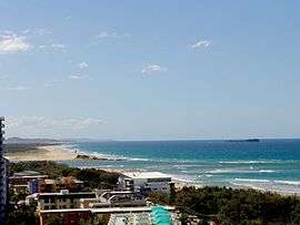 View of Maroochydore | |||||||||||||||
<mapframe>: The JSON content is not valid GeoJSON+simplestyle
| |||||||||||||||
 Maroochydore | |||||||||||||||
| Coordinates | 26°39′15″S 153°05′00″E | ||||||||||||||
| Population | 16,800 (2016 census)[1] | ||||||||||||||
| • Density | 302.7/km2 (784.0/sq mi) | ||||||||||||||
| Postcode(s) | 4558 | ||||||||||||||
| Area | 55.5 km2 (21.4 sq mi) | ||||||||||||||
| Location | 104 km (65 mi) from Brisbane | ||||||||||||||
| LGA(s) | Sunshine Coast Region | ||||||||||||||
| State electorate(s) | Maroochydore | ||||||||||||||
| Federal Division(s) | Fairfax | ||||||||||||||
| |||||||||||||||
| |||||||||||||||
The town was subdivided from the Cotton Tree reserve by Surveyor Thomas O'Connor in 1903. The land was acquired from William Pettigrew who had a timber depot at what is now Wharf Street. Its name comes from the Aboriginal indigenous Yuggera language word 'Muru-kutchi', meaning red-bill and referring to the black swan, which is commonly seen in the area.
Maroochydore is a major commercial area of the Sunshine Coast with most shopping precincts located in the central business district. It is home to the Sunshine Plaza shopping centre and the Sunshine Coast's major bus interchange for TransLink services operated by Sunbus. Maroochydore is also a venue of major surf sport carnivals, and is a popular holiday point from which to travel the rest of Queensland.
History
Maroochydore Post Office opened on 4 October 1922 (a receiving office had been open from 1891 until 1898, and from 1916).[4]
The Maroochydore Library opened in 1975.[5]
Horton Park Golf Club is in Maroochydore. The club will be relocating to Bli Bli in May,2015 and changing names to Maroochy River Golf Club.[6]
The relocation of the Golf Course has allowed the Sunshine Regional Council to develop the old golf course into a new city centre for the region known as Sunshine Central.
The redevelopment is next to Sunshine Cove a new sustainable residential and commercial development that has revitalized the general town centre and the development won the award from the Urban Development Institute of Australia for the best residential property Development at its annual Australian awards night in 2016.[7]
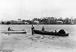 Fish haul, 1907
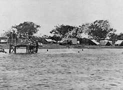 Camping, 1932
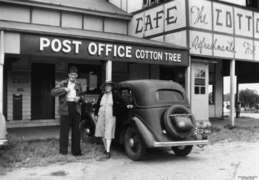 Cotton Tree Post Office
Heritage listings
Cotton Tree has a number of heritage-listed sites, including:
- Cotton Tree Parade: Cotton Tree Caravan Park[8]
Geography
The boundaries of the Maroochydore as a locality are well-defined., but as a town, Maroochydore does not have strict boundaries, but the boundary used by Sunshine Coast Regional Council (formerly the Maroochy Shire) includes a region from the southern boundary of Sunshine Coast Airport to the Mooloolah River at Mooloolaba and Kawana Way. This corresponds to the historic Australian Bureau of Statistics urban centres of Maroochydore–Mooloolaba and Mudjimba. The central business district (CBD) for the area is located on Horton Parade, Maroochydore.
The Maroochydore urban centre consists of Alexandra Headland, part of Bli Bli, Buderim (section within about one km of Sunshine Motorway), Cotton Tree (Australia Post 4558), Kuluin, Maroochydore, Maroochy Waters, Maroochy River, Mooloolaba, Mountain Creek, Mudjimba, Pacific Paradise and Twin Waters
The current ASGC, applicable to the 2001 and 2006 censuses, has placed all of Buderim and Mountain Creek under the Buderim SLA.
Maroochy Waters
Maroochy Waters is a waterfront, residential estate located in Maroochydore adjacent to the Maroochy River in Queensland, Australia. It is one of the last canal projects to be built in Queensland with direct access to river system and Coral Sea. Sunshine Coast Region Council has an annual dredging program to replenish the sand beaches.
The canals plus all infrastructure were built in three stages. These were the late 1970s, mid 1980s and early 1990s. The deep water canal plays a role in flood relief and the land is higher than Maroochydore CBD which has recorded floods in the last 30 years. The canal's main reach, which extends for more than one km was the training ground for 1992 Olympic K-1 1000 m gold medalist Clint Robinson.
Transport
Maroochydore's suburbs are served by Sunbus, who operate from outside the Sunshine Plaza in the CBD. Various bus routes connect Maroochydore to Buderim, Coolum, Kawana Waters, Caloundra, Nambour and Noosa.[9]
Maroochydore is accessible via train and connecting bus via Nambour, Woombye and Landsborough stations on the Nambour & Gympie North Line has regular services to Brisbane, operated by Queensland Rail. There are also coach services from Sunshine Plaza to Brisbane Airport.[10]

Sunshine Coast Airport is located just north of the urban centre in Marcoola. It offers domestic flights to state capital cities around Australia.
There are plans to create a new railway line that would extend from the current Gympie North line. The proposed line would connect Caloundra, Kawana Waters and Maroochydore with Brisbane and would terminate at the Sunshine Coast Airport. A light rail system has also been proposed, which would leave from the Maroochydore CBD and connect the local regional hubs before terminating at Caloundra.
Population
Census populations for the Maroochydore urban centre have been recorded since 1933, and for Mudjimba since 1981.
| Year | Population (Total) |
Population (Maroochydore) |
Population (Mudjimba) |
|---|---|---|---|
| 1933 | 630 | 630 | |
| 1947 | 2,164 | 2,164 | |
| 1954 | 2,655 | 2,655 | |
| 1961 | 3,068 | 3,068 | |
| 1966 | 4,106 | 4,106 | |
| 1971 | 6,374 | 6,374 | |
| 1976 | 10,283 | 10,283 | |
| 1981 | 18,444 | 17,460 | 984 |
| 1986 | 22,099 | 20,635 | 1,464 |
| 1991 | 30,856 | 28,509 | 2,347 |
| 1996 | 40,766 | 36,406 | 4,360 |
| 2001 | 47,951 | 39,458 | 8,493 |
| 2006 | 49,743 | 39,123 | 10,620 |
Amenities
Sunshine Coast Regional Council operates a public library at 44 Sixth Avenue, Cotton Tree.[11]
The Maroochydore branch of the Queensland Country Women's Association meets at 104 Memorial Avenue.[12]
Education
The main state secondary school in the town is Maroochydore State High School (1964). Other schools in the area include:
- Bli Bli State School (1901)
- Kuluin State School (1987)
- Maroochydore State School (1921)
- Mooloolaba State School (1933)
- Mountain Creek State School (1994)
- Mountain Creek State High School (1995)
- Pacific Paradise State School (1992)
- Immanuel Lutheran College (1982)
- Stella Maris Catholic Primary School (1980)
- Siena Catholic College (1997)
In popular culture
Maroochydore is the sixth town mentioned in the original (Australian) version of the song "I've Been Everywhere".
See also
References
- Australian Bureau of Statistics (27 June 2017). "Maroochydore (SSC)". 2016 Census QuickStats. Retrieved 6 November 2018.

- "Maroochydore - population centre in the Sunshine Coast Region (entry 21053)". Queensland Place Names. Queensland Government. Retrieved 6 November 2018.
- "Maroochydore - suburb in the Sunshine Coast Region (entry 48750)". Queensland Place Names. Queensland Government. Retrieved 6 November 2018.
- Premier Postal History. "Post Office List". Premier Postal Auctions. Retrieved 10 May 2014.
- "Queensland Public Libraries Statistical Bulletin 2016-2017" (PDF). Public Libraries Connect. State Library of Queensland. November 2017. p. 16. Archived (PDF) from the original on 30 January 2018. Retrieved 22 January 2018.
- "Maroochydore". Archived from the original on 19 December 2014. Retrieved 21 October 2014.
- "Archived copy". Archived from the original on 23 November 2016. Retrieved 23 November 2016.CS1 maint: archived copy as title (link)
- "Cotton Tree Caravan Park (entry 602707)". Queensland Heritage Register. Queensland Heritage Council. Retrieved 14 July 2013.
- Translink Queensland. "All bus timetables". Archived from the original on 25 July 2011. Retrieved 21 June 2011.
- Sunair. "Brisbane Airport Transit Stop". Archived from the original on 6 July 2011. Retrieved 21 June 2011.
- "Maroochydore Library". Public Libraries Connect. State Library of Queensland. 21 August 2015. Archived from the original on 23 January 2018. Retrieved 22 January 2018.
- "Branch Locations". Queensland Country Women's Association. Archived from the original on 26 December 2018. Retrieved 26 December 2018.
External links
| Wikimedia Commons has media related to Maroochydore, Queensland. |