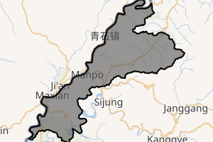
Manpo
Manpho (Korean pronunciation: [man.pʰo]) is a city of northwestern Chagang Province, North Korea. As of 2008, it had an estimated population of 116,760. It looks across the border to the city of Ji'an, Jilin province, China.
Manpo 만포시 | |
|---|---|
| Korean transcription(s) | |
| • Chosŏn'gŭl | 만포시 |
| • Hancha | 滿浦市 |
| • McCune-Reischauer | Manp'o si |
| • Revised Romanization | Manpo-si |
 View of Manpo from the Ji'an Yalu River Border Railway Bridge | |
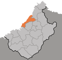 Map of Chagang showing the location of Manpo | |
| |
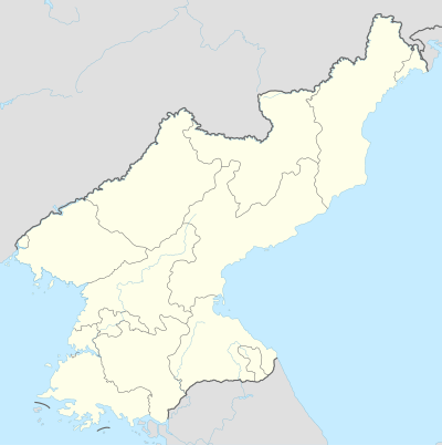 Manpo Location within North Korea | |
| Coordinates: 41.157°N 126.290°E | |
| Country | North Korea |
| Province | Chagang Province |
| Administrative divisions | 11 tong, 15 ri |
| Population (2008) | |
| • Total | 116,760 |
| • Dialect | P'yŏngan |
| Time zone | UTC+9 (Pyongyang Time) |
History
Manp'o was incorporated as a city in 1961.
Geography
Along the shores of the Yalu River and the Kŏnp'o River are the small Kosan Plain and the Kŏnha Plain.
The yearly average temperature is 6.5 °C (43.7 °F); the January average temperature, −14.4 °C (6.1 °F); and the July average temperature, 23.6 °C (74.5 °F). The yearly average rainfall is 947.8 millimetres (37.31 in), generous due to the mountainous terrain.
Climate
Manpo has a humid continental climate (Köppen climate classification: Dwa).
| Climate data for Manpo | |||||||||||||
|---|---|---|---|---|---|---|---|---|---|---|---|---|---|
| Month | Jan | Feb | Mar | Apr | May | Jun | Jul | Aug | Sep | Oct | Nov | Dec | Year |
| Average high °C (°F) | −6.3 (20.7) |
−1.9 (28.6) |
5.9 (42.6) |
15.8 (60.4) |
22.6 (72.7) |
26.2 (79.2) |
28.3 (82.9) |
27.8 (82.0) |
22.2 (72.0) |
15.4 (59.7) |
4.9 (40.8) |
−4.0 (24.8) |
13.1 (55.5) |
| Daily mean °C (°F) | −12.9 (8.8) |
−8.6 (16.5) |
0.2 (32.4) |
8.8 (47.8) |
15.4 (59.7) |
20.1 (68.2) |
23.4 (74.1) |
22.9 (73.2) |
16.2 (61.2) |
8.8 (47.8) |
−0.1 (31.8) |
−9.4 (15.1) |
7.1 (44.7) |
| Average low °C (°F) | −19.5 (−3.1) |
−15.2 (4.6) |
−5.5 (22.1) |
1.9 (35.4) |
8.3 (46.9) |
14.0 (57.2) |
18.6 (65.5) |
18.0 (64.4) |
10.3 (50.5) |
2.2 (36.0) |
−5.1 (22.8) |
−14.8 (5.4) |
1.1 (34.0) |
| Average precipitation mm (inches) | 11 (0.4) |
13 (0.5) |
20 (0.8) |
51 (2.0) |
71 (2.8) |
116 (4.6) |
236 (9.3) |
220 (8.7) |
90 (3.5) |
44 (1.7) |
33 (1.3) |
16 (0.6) |
921 (36.2) |
| Source: Climate-Data.org [1] | |||||||||||||
Administrative divisions
Manp'o is divided into 11 tong and 15 ri:
|
|
Economy
Lumber processing and transportation are well developed.
Transportation
Man'po is connected to other cities in North Korea by road, and by the Unha, Manpo and Pukbunaeryuk lines of the Korean State Railway.
See also
References
- "Climate: Manpo". Climate-Data.org. Retrieved June 30, 2018.
Further reading
- Dormels, Rainer. North Korea's Cities: Industrial facilities, internal structures and typification. Jimoondang, 2014. ISBN 978-89-6297-167-5
External links
- (in Korean) In Korean language online encyclopedias:
- North Korea Uncovered, (North Korea Google Earth) see much of Manpo's industrial and political infrastructure on Google Earth.
- City profile of Manpo

| Wikimedia Commons has media related to Manpo. |