Madison Township, Butler County, Ohio
Madison Township is one of thirteen townships in Butler County, Ohio, United States. Located in northeastern Butler County just west of Middletown, it had a population of 8,448 people as of the 2010 census,[3] down from 8,611 in 2000. While it surrounds the city of Trenton, the city is no longer part of the township. It is named for James Madison, president of the United States at the time of its creation in 1810, and is one of twenty Madison Townships statewide.[4]
Madison Township, Butler County, Ohio | |
|---|---|
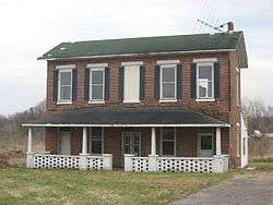 Former Mill Office and Post Office in Woodsdale | |
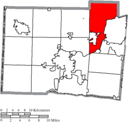 Location of Madison Township in Butler County | |
| Coordinates: 39°32′21″N 84°25′29″W | |
| Country | United States |
| State | Ohio |
| County | Butler |
| Area | |
| • Total | 36.1 sq mi (93.6 km2) |
| • Land | 35.8 sq mi (92.6 km2) |
| • Water | 0.4 sq mi (1.0 km2) |
| Elevation | 725 ft (221 m) |
| Population (2010) | |
| • Total | 8,448 |
| • Density | 236/sq mi (91.2/km2) |
| Time zone | UTC-5 (Eastern (EST)) |
| • Summer (DST) | UTC-4 (EDT) |
| FIPS code | 39-46340[2] |
| GNIS feature ID | 1085813[1] |
| Website | madisontownshiponline |

Geography
The township is in what is commonly known as the Congress Lands, that part of Ohio surveyed under the regular U.S. government survey. It originally consisted of 32 whole and 19 fractional sections.
Located in the northeastern corner of the county, it borders the following townships:
- German Township, Montgomery County - north
- Franklin Township, Warren County - east
- Lemon Township - southeast
- Liberty Township - south
- Fairfield Township - southwest, south of St. Clair Township
- St. Clair Township - southwest, north of Fairfield Township
- Wayne Township - west
- Gratis Township, Preble County - northwest
It is the only county township to border Montgomery County.
Within Madison Township are located several unincorporated communities:
- Poasttown, in the northeastern part of the township
- West Middletown, in the eastern part of the township
- Woodsdale, on the border with St. Clair Township in the township's far south
History
The township, the ninth in order of creation, was erected from Lemon Township by the Butler County Commissioners on May 7, 1810, following a petition by residents of the district. Its boundaries were:
- Beginning on the west bank of the Miami at the southwest corner of township No. 1 of the fourth range; thence north with the western boundary line of the said fourth range to the boundary line of the said county of Butler; thence east with the said northern boundary line to the Miami; thence south and southwardly with the meanders of the Miami to the place of the meanders of the Miami to the place of beginning.
The first election for township officers was on May 19, 1810.
Historic population figures
- 1900—2,166
- 1910—2,395
- 1920—2,502
- 1930—2,836
- 1940—3,697
- 1950—3,511
- 1960—6,222
- 1970—7,834
- 1980—8,588
- 1990—8,547
- 2000—8,611
- 2010—8,448
Government
The township is governed by a three-member board of trustees, who are elected in November of odd-numbered years to a four-year term beginning on the following January 1. Two are elected in the year after the presidential election and one is elected in the year before it. There is also an elected township fiscal officer,[5] who serves a four-year term beginning on April 1 of the year after the election, which is held in November of the year before the presidential election. Vacancies in the fiscal officership or on the board of trustees are filled by the remaining trustees.
Public services
The major roads are State Routes 4 (a main road from Cincinnati to Dayton via Middletown), 122 (which links Lebanon to Middletown), and 744.
The township is in the Madison Local School District and the Edgewood Local School District.
References
- "US Board on Geographic Names". United States Geological Survey. 2007-10-25. Retrieved 2008-01-31.
- "U.S. Census website". United States Census Bureau. Retrieved 2008-01-31.
- "Geographic Identifiers: 2010 Demographic Profile Data (G001): Madison township, Butler County, Ohio". U.S. Census Bureau, American Factfinder. Archived from the original on February 12, 2020. Retrieved February 21, 2014.
- "Detailed map of Ohio" (PDF). United States Census Bureau. 2000. Retrieved 2007-02-16.
- §503.24, §505.01, and §507.01 of the Ohio Revised Code. Accessed 4/30/2009.
- Bert S. Barlow, W.H. Todhunter, Stephen D. Cone, Joseph J. Pater, and Frederick Schneider, eds. Centennial History of Butler County, Ohio. Hamilton, Ohio: B.F. Bowen, 1905.
- Jim Blount. The 1900s: 100 Years In the History of Butler County, Ohio. Hamilton, Ohio: Past Present Press, 2000.
- Butler County Engineer's Office. Butler County Official Transportation Map, 2003. Fairfield Township, Butler County, Ohio: The Office, 2003.
- A History and Biographical Cyclopaedia of Butler County, Ohio with Illustrations and Sketches of Its Representative Men and Pioneers. Cincinnati, Ohio: Western Biographical Publishing Company, 1882.
- Ohio. Secretary of State. The Ohio municipal and township roster, 2002-2003. Columbus, Ohio: The Secretary, 2003.
External links
Municipalities and communities of Butler County, Ohio, United States | ||
|---|---|---|
| Cities |
| 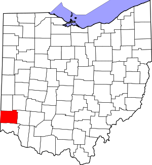 Map of Ohio highlighting Butler County |
| Villages | ||
| Townships | ||
| CDPs | ||
| Unincorporated communities | ||
| Footnotes | ‡This populated place also has portions in an adjacent county or counties | |