Lunner
Lunner is a municipality in Viken county, Norway. It is part of the traditional region of Hadeland. The administrative centre of the municipality is the village of Roa. Lunner was established when it was separated from the municipality of Jevnaker on 1 January 1898. From 1 January 2020 the municipality belongs to Viken county, it was Oppland before that.
Lunner kommune | |
|---|---|
 | |
 Coat of arms 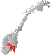 Viken within Norway | |
 Lunner within Viken | |
| Coordinates: 60°15′10″N 10°40′2″E | |
| Country | Norway |
| County | Viken |
| District | Hadeland |
| Administrative centre | Roa |
| Government | |
| • Mayor (2015) | Harald Tyrdal |
| Area | |
| • Total | 292 km2 (113 sq mi) |
| • Land | 272 km2 (105 sq mi) |
| Area rank | 281 in Norway |
| Population (2015) | |
| • Total | 9,003 |
| • Rank | 121 in Norway |
| • Density | 31/km2 (80/sq mi) |
| • Change (10 years) | 4.6% |
| Demonym(s) | Lynnersokning Lynbying Lunbying[1] |
| Time zone | UTC+01:00 (CET) |
| • Summer (DST) | UTC+02:00 (CEST) |
| ISO 3166 code | NO-3054 |
| Official language form | Bokmål[2] |
| Website | www |
General information
Name
The municipality (originally the parish) is named after the old Lunner farm (Old Norse: Lunnar), since the first church was built here. The name is the plural form of lunnr "log". (The farm and the church are located on a long hill which was probably compared to a log.)[3]
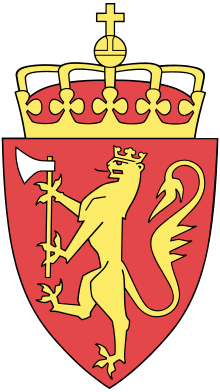
Coat-of-arms
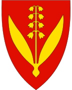
The coat-of-arms is from modern times. They were granted on 4 April 1986. The arms show a Lily of the Valley, as a symbol for the forests in the area. The Lily of the Valley is a very common flower in the meadows and forests. The flowers also symbolize the eight schools in the municipality.[4]
| Ancestry | Number |
|---|---|
| 148 | |
| 136 | |
| 56 | |
| 47 | |
| 47 | |
| 46 | |
| 34 | |
| 34 |
Geography

Lunner is bordered to the north by the municipality of Gran, to the east by Nannestad, to the south by Nittedal and Oslo, and to the west by Jevnaker. There are several population centers in the municipality. Amongst these are: Harestua, Grua, Roa, and the village of Lunner.
Lunner is 23 kilometres (14 mi) on a north–south axis (23.1 km with water included) and 16.2 kilometres (10.1 mi) on an east–west axis. It lies at the southern end of Oppland county. The highest point is the Bislingflaka with a height of 691 metres (2,267 ft). Lakes in the region include Avalsjøen.
Transportation
The Gjøvikbane and Bergensbane railway lines pass through the municipality.
Attractions

- Lunner church
- Hadeland Mining Museum at Grua
- Harestua Solar Observatory, near Piperen
- Kloppstock Music Festival used to be held every summer at Harestua
Notable residents
- Ivar Ballangrud (7 March 1904–1 June 1969), a speed skater, was born in Lunner.
- Knut Schreiner, ("Euroboy") from the punk rock band Turbonegro, grew up in Harestua, Lunner
Sister cities
The following cities are twinned with Lunner:[6]

References
- "Navn på steder og personer: Innbyggjarnamn" (in Norwegian). Språkrådet.
- "Forskrift om målvedtak i kommunar og fylkeskommunar" (in Norwegian). Lovdata.no.
- Rygh, Oluf (1900). Norske gaardnavne: Kristians amt (Anden halvdel) (in Norwegian) (4 ed.). Kristiania, Norge: W. C. Fabritius & sønners bogtrikkeri. p. 129.
- Norske Kommunevåpen (1990). "Nye kommunevåbener i Norden". Retrieved 2009-01-01.
- "Immigrants and Norwegian-born to immigrant parents". ssb.no. Archived from the original on 9 July 2017. Retrieved 29 June 2015.
- "Vennskapskommuner" (in Norwegian). Lunner kommune. Archived from the original on 2009-03-31. Retrieved 2009-01-01.
External links
| Wikimedia Commons has media related to Lunner. |
| Look up Lunner in Wiktionary, the free dictionary. |
- Municipal fact sheet from Statistics Norway

 |  | ||||||||||||||||||||||||||||||||||||
|
| Authority control |
|---|