Linha da Beira Baixa
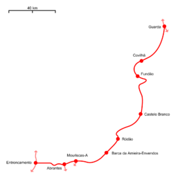
Linha da Beira Baixa, originally called Caminho de Ferro da Beira Baixa, is a railway line which connects the stations of Entroncamento and Guarda in central Portugal. The first section, from Abrantes to Covilhã was opened on the 6th of September 1891. The line to Guarda was opened on the 11th of May 1893.[3] At the time, only the section from Abrantes to Guarda was considered to be part of Linha da Beira Baixa, while the route from Entroncamento to Abrantes belonged to the Linha do Leste.
| Linha da Beira Baixa | |||
|---|---|---|---|
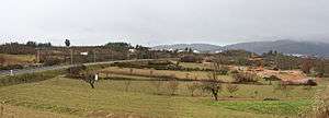 Linha da Beira Baixa close to Fundão. | |||
| Overview | |||
| Status | Operational | ||
| Termini | Entroncamento Guarda | ||
| Operation | |||
| Owner | Infraestruturas de Portugal | ||
| Technical | |||
| Track gauge | Iberian | ||
| Electrification | 25 kV / 50 kHz Overhead line | ||
| |||
| Location on the network |
 + Entroncamento × Guarda (🔎) |
| Linha da Beira Baixa | |||||||||||||||||||||||||||||||||||||||||||||||||||||||||||||||
|---|---|---|---|---|---|---|---|---|---|---|---|---|---|---|---|---|---|---|---|---|---|---|---|---|---|---|---|---|---|---|---|---|---|---|---|---|---|---|---|---|---|---|---|---|---|---|---|---|---|---|---|---|---|---|---|---|---|---|---|---|---|---|---|
| |||||||||||||||||||||||||||||||||||||||||||||||||||||||||||||||
| |||||||||||||||||||||||||||||||||||||||||||||||||||||||||||||||
| |||||||||||||||||||||||||||||||||||||||||||||||||||||||||||||||
| |||||||||||||||||||||||||||||||||||||||||||||||||||||||||||||||
| |||||||||||||||||||||||||||||||||||||||||||||||||||||||||||||||
| |||||||||||||||||||||||||||||||||||||||||||||||||||||||||||||||
| |||||||||||||||||||||||||||||||||||||||||||||||||||||||||||||||
| |||||||||||||||||||||||||||||||||||||||||||||||||||||||||||||||
| |||||||||||||||||||||||||||||||||||||||||||||||||||||||||||||||
| |||||||||||||||||||||||||||||||||||||||||||||||||||||||||||||||
| |||||||||||||||||||||||||||||||||||||||||||||||||||||||||||||||
| |||||||||||||||||||||||||||||||||||||||||||||||||||||||||||||||
| |||||||||||||||||||||||||||||||||||||||||||||||||||||||||||||||
| |||||||||||||||||||||||||||||||||||||||||||||||||||||||||||||||
| |||||||||||||||||||||||||||||||||||||||||||||||||||||||||||||||
| |||||||||||||||||||||||||||||||||||||||||||||||||||||||||||||||
| |||||||||||||||||||||||||||||||||||||||||||||||||||||||||||||||
| |||||||||||||||||||||||||||||||||||||||||||||||||||||||||||||||
| |||||||||||||||||||||||||||||||||||||||||||||||||||||||||||||||
| |||||||||||||||||||||||||||||||||||||||||||||||||||||||||||||||
| |||||||||||||||||||||||||||||||||||||||||||||||||||||||||||||||
| |||||||||||||||||||||||||||||||||||||||||||||||||||||||||||||||
| |||||||||||||||||||||||||||||||||||||||||||||||||||||||||||||||
| |||||||||||||||||||||||||||||||||||||||||||||||||||||||||||||||
| |||||||||||||||||||||||||||||||||||||||||||||||||||||||||||||||
| |||||||||||||||||||||||||||||||||||||||||||||||||||||||||||||||
| |||||||||||||||||||||||||||||||||||||||||||||||||||||||||||||||
See also
- List of railway lines in Portugal
- List of Portuguese locomotives and railcars
- History of rail transport in Portugal
References
- Photo in 2010, by Valério dos Santos, on Flickr. Retrieved 14 January 2019
- Photos in 2010, and , by Valério dos Santos, on Flickr. Retrieved 14 January 2019
- Torres, Carlos Manitto (1 February 1958). "A evolução das linhas portuguesas e o seu significado ferroviário" (PDF). Gazeta dos Caminhos de Ferro. Retrieved 14 January 2019.
Sources
- "2019 Network Statement" (PDF). 7 December 2018. Retrieved 20 January 2019. Cite journal requires
|journal=(help)
This article is issued from Wikipedia. The text is licensed under Creative Commons - Attribution - Sharealike. Additional terms may apply for the media files.