Leiria District
The District of Leiria (Portuguese: Distrito de Leiria [lɐjˈɾi.ɐ] (![]()
| Name | Status |
|---|---|
| Alcobaça | C |
| Alvaiázere | T |
| Ansião | T |
| Batalha | T |
| Bombarral | T |
| Caldas da Rainha | C |
| Castanheira de Pera | T |
| Figueiró dos Vinhos | T |
| Leiria | C |
| Marinha Grande | C |
| Nazaré | T |
| Óbidos | T |
| Pedrógão Grande | T |
| Peniche | C |
| Pombal | C |
| Porto de Mós | T |
District of Leiria | |
|---|---|
 Coat of arms | |
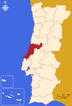 | |
| Country | Portugal |
| Region | Centro |
| Historical province | Beira Litoral and Estremadura |
| No. of municipalities | 16 |
| No. of parishes | 148 |
| Capital | Leiria |
| Area | |
| • Total | 3,515 km2 (1,357 sq mi) |
| Population 2011 | |
| • Total | 470,930 |
| • Density | 130/km2 (350/sq mi) |
| ISO 3166 code | PT-10 |
| No. of parliamentary representatives | 10 |
Summary of votes and seats won 1976-2019
Summary of election results from Leiria district, 1976-2019
| Parties | % | S | % | S | % | S | % | S | % | S | % | S | % | S | % | S | % | S | % | S | % | S | % | S | % | S | % | S | % | S |
|---|---|---|---|---|---|---|---|---|---|---|---|---|---|---|---|---|---|---|---|---|---|---|---|---|---|---|---|---|---|---|
| 1976 | 1979 | 1980 | 1983 | 1985 | 1987 | 1991 | 1995 | 1999 | 2002 | 2005 | 2009 | 2011 | 2015 | 2019 | ||||||||||||||||
| PS | 31.1 | 4 | 23.2 | 3 | 22.7 | 3 | 32.7 | 4 | 19.6 | 2 | 18.7 | 2 | 23.0 | 3 | 36.7 | 4 | 36.8 | 4 | 29.5 | 3 | 35.6 | 4 | 30.1 | 4 | 20.7 | 3 | 24.8 | 3 | 31.1 | 4 |
| PSD | 31.2 | 4 | In AD | 35.6 | 4 | 38.6 | 5 | 60.8 | 9 | 61.2 | 7 | 43.3 | 5 | 42.6 | 5 | 50.8 | 6 | 39.8 | 5 | 34.9 | 4 | 47.0 | 6 | In PàF | 33.5 | 5 | ||||
| CDS-PP | 19.4 | 2 | 16.2 | 2 | 12.2 | 1 | 6.0 | 4.8 | 11.4 | 1 | 9.9 | 1 | 9.8 | 1 | 8.9 | 1 | 12.6 | 1 | 12.8 | 1 | 5.3 | |||||||||
| PCP/APU/CDU | 7.3 | 1 | 10.9 | 1 | 9.7 | 1 | 9.5 | 1 | 7.9 | 1 | 5.9 | 4.5 | 4.5 | 5.3 | 4.1 | 4.6 | 5.1 | 5.0 | 5.1 | 4.3 | ||||||||||
| AD | 56.2 | 7 | 59.8 | 7 | ||||||||||||||||||||||||||
| PRD | 15.3 | 2 | 3.0 | |||||||||||||||||||||||||||
| BE | 1.7 | 2.2 | 5.5 | 9.5 | 1 | 5.1 | 9.7 | 1 | 9.4 | 1 | ||||||||||||||||||||
| PàF | 48.4 | 6 | ||||||||||||||||||||||||||||
| Total seats | 11 | 10 | ||||||||||||||||||||||||||||
| Source: Comissão Nacional de Eleições | ||||||||||||||||||||||||||||||
See also
- Casal de São Simåo, a village in the district of Leiria
This article is issued from Wikipedia. The text is licensed under Creative Commons - Attribution - Sharealike. Additional terms may apply for the media files.