Leadenhall Street
Leadenhall Street (/ˈlɛdənˌhɔːl/) is a street in the City of London. It is about 1⁄3-mile-long (0.54 km) and links Cornhill in the west to Aldgate in the east. It was formerly the start of the A11 road from London to Norwich, but that route now starts further east at Aldgate.
.jpg)
Leadenhall Street has always been a centre of commerce. It connected the medieval market of Leaden Hall with Aldgate, the eastern gate in the Roman city wall. The East India Company had its headquarters there, as later did the Peninsular and Oriental Steam Navigation Company (P&O). By the mid 20th century, grand stone-faced offices lined the street.[1] Today it is closely associated with the insurance industry and particularly the Lloyd's insurance market, with its dramatic building in the adjacent Lime Street. It forms part of a cluster of tall buildings including the 48-storey “Cheesegrater” and the 38-storey “Scalpel”. Other buildings planned for the street include the 57-storey “Diamond”, the 50-storey “Prussian Blue” and the 34-storey “Gotham City”[2]. Older buildings like the medieval church of St Katherine Cree seem incongruous among these towers, but the medieval heritage is preserved in the narrow slightly curving street and dense commercial activity.
History
Although Leadenhall Street is within the walls of Roman Londinium, and a map published in 1897 showed it as a Roman street[3], this remains speculative. The basilica, the largest building in Londinium, extended beneath the western end of Leadenhall Street.[4] Roman remains have also been found on both sides of Leadenhall Street, beneath East India House (now No 12) and the P&O Building (now St Helen’s Square).[5]
The street probably originated in the medieval period. It appears in a map of London in 1270,[6] then named Cornhulle in the west and Alegatestrete in the east. The name derives from a lead-roofed mansion, first used as a poultry market in 1321.[7] The street runs from this Leaden Hall towards Aldgate, the eastern gate of the city wall. The only remaining buildings from this period are the churches of St Katherine Cree and St Andrew Undershaft in the adjacent street of St Mary Axe.
The name “Ledenhall Street” first appears on a map from 1658.[8] In the Great Fire of London in 1666, the north-eastern edge of the damaged area reached Leadenhall Market, leaving Leadenhall Street itself intact.[9]
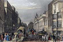
From 1729 to 1861 the largest building in the street was East India House, the headquarters of the East India Company. In 1840 Leadenhall Street comprised mainly 4-storey stone buildings, as shown in a pictorial record by John Tallis. Its business directory lists 158 separate premises with a wide variety of trades and merchants.[10] Apart from St Katherine Cree, there are no survivors from this period. The oldest is the former Leadenhall Press building (No 50) from 1868.
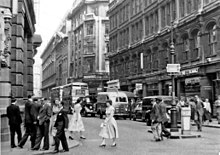
In the Victorian era, merchants were progressively replaced by banks, typically sturdy 6-storey stone buildings. Notable survivors include Lloyds Bank (No 113), the former Bank of Adelaide (No 11), the former Grace & Co (No 147) and the Lutyens designed No 139.
Bomb damage during World War II mainly affected the south side of Leadenhall Street to the east of Lime Street (No 26 to 49).[11] Early post-war reconstruction matched the height of existing buildings, while introducing modern styles such as the former Scandinavian Bank (No 36) and the former Bank of Credit and Commerce International (No 100). In the late 1980s, the former Midland Bank (No 69) and the former Swiss Re House (No 77) introduced the post-modern style.
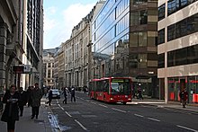
Today Leadenhall Street is closely associated with the insurance industry and particularly the Lloyd's insurance market, which occupied No 12 from 1928 to 1958, and has since been based in the adjacent Lime Street. The 14-storey Lloyd's building, completed in 1986, started a trend for dramatic architecture in the area.
Tall buildings on Leadenhall Street are constrained by the protected view of St Paul's Cathedral from Fleet Street.[12] To avoiding impinging on this view, the 48-storey Leadenhall Building (No 122) adopted a distinctive sloping profile, known as “The Cheesegrater”, while “The Scalpel”, a 38-storey building across the street (52 Lime Street), slopes in the opposite direction. Other buildings being developed, including the 57-storey "Diamond" (No 100) and the 50-storey “Prussian Blue” on the corner with Bishopsgate, will fill in the gaps in this cluster of buildings.
Notable buildings and companies
The street was home to East India House from 1729 until its demolition in 1861; that site is now occupied by Lloyd's of London. Leadenhall Market is accessible via Whittington Avenue, a small side-road off Leadenhall Street.
The London Metal Exchange is located at No. 56, opposite the church of St. Katharine Cree, which dates from 1631 and was made a Grade I listed building in 1950.
Several major companies are headquartered on Leadenhall Street, including Xchanging, Ace European Group, Digital Guardian EMEA, and Allianz Global Risks. Due to the proximity of Lloyd's, a number of other insurance firms and brokers also have offices on Leadenhall Street. The Leadenhall Building, located at No. 122 and opposite the Lloyd's building, is a 48-storey skyscraper, used as the venue for the BBC's The Apprentice interviews. The Scalpel, a 38-storey skyscraper at 52–54 Lime Street, is being constructed at the junction of Leadenhall Street and Lime Street.[13] A new office development, including a 34-storey tower, has been proposed for 40 Leadenhall Street.[14]
Cultural references
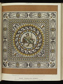
The Leadenhall Street Mosaic is a Romano-British mosaic pavement from the first or second century depicting Bacchus astride a tigress. It was discovered during building work on East India House. The surviving pieces have been in the British Museum since 1880.[15]
One of the first telephone exchanges in London was installed at 101 Leadenhall Street in 1879.[16]
The Leadenhall Building (No. 122) is used as the venue for the BBC's The Apprentice interviews.
See also
References
- Bradley, Simon; Pevsner, Nikolaus (2002). The Buildings of England, London 1: The City of London. New Haven and London: Yale University Press. pp. 529–532.
- "City Corporation releases new images of future skyline". City of London. Retrieved 3 August 2020.
- "Plan Of Roman London - Post AD190". Mapco. Retrieved 2 August 2020.
- "Roman Londinium - Interactive Map". HeritageDaily. Retrieved 2 August 2020.
- "Inventory of Roman London: Structures within the walls". British History Online. Retrieved 2 August 2020.
- "Medieval London, 1270 - 1300". Layers of London. Retrieved 3 August 2020.
- "Heritage". Leadenhall Market. Retrieved 2 August 2020.
- "W. Faithorne and R. Newcourt Map (1658)". Layers of London. Retrieved 3 August 2020.
- "The Great Fire of London" (PDF). City of London. Retrieved 2 August 2020.
- "John Tallis's London Street Views". CG Publishing. Retrieved 2 August 2020.
- "Bomb Damage (1945)". Layers of London. Retrieved 2 August 2020.
- "Protected views and tall buildings". City of London. Retrieved 2 August 2020.
- "The Scalpel The city skyline defined". thescalpelec3.co.uk. Retrieved 12 November 2017.
- "Henderson Global Investors launches plans for new office building at 40 Leadenhall Street". Henderson Global Investors. 17 September 2013. Retrieved 7 November 2013.
- "mosaic pavement". British Museum. Retrieved 2 August 2020.
- "UK telephone history". Retrieved 2 August 2020.
External links

| Wards |  | |
|---|---|---|
| Enclaves | ||
| Localities | ||
| Attractions |
| |
| Notable structures | ||
| Civil parishes | ||
| Bridges |
| |
| Rail and tube stations | ||
| Topics | ||
| ||