Laravale, Queensland
Laravale is a locality in the Scenic Rim Region of South East Queensland, Australia.[2] At the 2016 census, Laravale recorded a population total of 189.[1]
| Laravale Queensland | |||||||||||||||
|---|---|---|---|---|---|---|---|---|---|---|---|---|---|---|---|
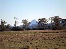
 Round Mountain, 2016 | |||||||||||||||
 Laravale | |||||||||||||||
| Coordinates | 28°5′14″S 152°56′10″E | ||||||||||||||
| Population | 189 (2016 census)[1] | ||||||||||||||
| Postcode(s) | 4285 | ||||||||||||||
| LGA(s) | Scenic Rim Region | ||||||||||||||
| State electorate(s) | Scenic Rim | ||||||||||||||
| Federal Division(s) | Wright | ||||||||||||||
| |||||||||||||||
Geography
Part of the southern border is marked by the Widgee Creek, the Logan River and the Mount Lindesay Highway.
In the east the northern extent of the Jinbroken Range elevates the terrain to heights greater than 350 metres (1,150 ft) above sea level. Agriculture, including dairying, has developed in the more fertile areas adjacent to the Logan River.
The Sydney–Brisbane rail corridor also passes through the locality.
History
Errisvale Provisional School opened oon 22 February 1900. In 1907 it was renamed Laravale Provisional School. On 1 January 1909 it became Laravale State School. The school was mothballed on 31 December 2007 and then closed on 31 December 2010.[3][4] The school was located at 77 Christmas Creek Road (28.0926°S 152.9376°E).[5]
The Beaudesert Shire Tramway had a stop at Laravale.
It was once part of Beaudesert Shire.
Demographics
Laravale has a population of 189 at the 2016 census. The locality contains 86 households, in which 50.5% of the population are males and 49.5% of the population are females with a median age of 40, 2 years above the national average. The average weekly household income is $1,321, $117 below the national average.
0.0% of Laravale's population is either of Aborigional or Torres Strait Islander descent. 61.4% of the population aged 15 or over is either registered or de facto married, while 38.6% of the population is not married. 24.2% of the population is currently attending some form of a compulsory education. The most common nominated ancestries were Australian (33.2%), English (31.0%) and Scottish (12.2%), while the most common country of birth was Australia (91.1%), and the most commonly spoken language at home was English (93.7%). The most common nominated religions were Catholic (27.6%), No religion (21.8%) and Anglican (16.7%). The most common occupation was a manager (22.4%) and the majority/plurality of residents worked 40 or more hours per week (48.3%).[1]
See also
References
- Australian Bureau of Statistics (27 June 2017). "Laravale". 2016 Census QuickStats. Retrieved 19 January 2020.

- "Laravale (entry 47779)". Queensland Place Names. Queensland Government. Retrieved 5 September 2014.
- Queensland Family History Society (2010), Queensland schools past and present (Version 1.01 ed.), Queensland Family History Society, ISBN 978-1-921171-26-0
- "Opening and closing dates of Queensland Schools". Queensland Government. Retrieved 30 October 2019.
- Chiclcott, Tanya; Vlasic, Kimberley (7 June 2013). "Full school asssets sale list". The Courier-Mail. Retrieved 30 October 2019.
Further reading
- Laravale State School (1900), 70th anniversary, 1900-1970, Laravale State School
- Laravale's link to the past : written and produced by the members of a sub-committee of the Laravale State School Centenary Committee, The School, 1999