La Chapelle-Saint-Géraud
La Chapelle-Saint-Géraud is a commune in the Corrèze department in central France.
La Chapelle-Saint-Géraud | |
|---|---|
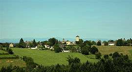 A general view of La Chapelle-Saint-Géraud | |
.svg.png) Coat of arms | |
Location of La Chapelle-Saint-Géraud 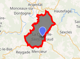
| |
 La Chapelle-Saint-Géraud  La Chapelle-Saint-Géraud | |
| Coordinates: 45°02′25″N 1°57′17″E | |
| Country | France |
| Region | Nouvelle-Aquitaine |
| Department | Corrèze |
| Arrondissement | Tulle |
| Canton | Argentat |
| Government | |
| • Mayor (2014–2020) | Gilles Dupuy |
| Area 1 | 17.59 km2 (6.79 sq mi) |
| Population (2017-01-01)[1] | 198 |
| • Density | 11/km2 (29/sq mi) |
| Time zone | UTC+01:00 (CET) |
| • Summer (DST) | UTC+02:00 (CEST) |
| INSEE/Postal code | 19045 /19430 |
| Elevation | 180–562 m (591–1,844 ft) (avg. 540 m or 1,770 ft) |
| 1 French Land Register data, which excludes lakes, ponds, glaciers > 1 km2 (0.386 sq mi or 247 acres) and river estuaries. | |
Population
| Year | Pop. | ±% |
|---|---|---|
| 1962 | 296 | — |
| 1968 | 307 | +3.7% |
| 1975 | 276 | −10.1% |
| 1982 | 249 | −9.8% |
| 1990 | 219 | −12.0% |
| 1999 | 226 | +3.2% |
| 2008 | 221 | −2.2% |
Geography
The Maronne river forms the commune's northeastern boundary.
See also
References
- "Populations légales 2017". INSEE. Retrieved 6 January 2020.
| Wikimedia Commons has media related to La Chapelle-Saint-Géraud. |
| Authority control |
|
|---|
This article is issued from Wikipedia. The text is licensed under Creative Commons - Attribution - Sharealike. Additional terms may apply for the media files.