Kurozwęki
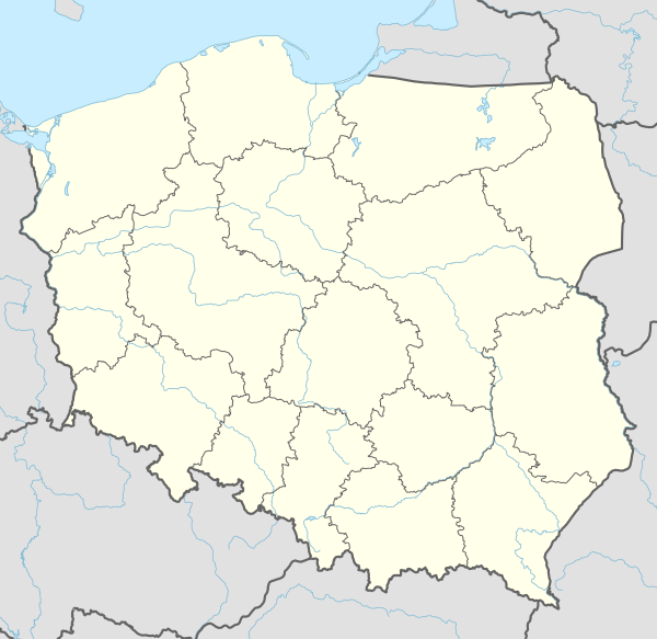
Kurozwęki[2][3][4] [kurɔˈzvɛnki] is a village in the district of Gmina Staszów, within Staszów County, Świętokrzyskie Voivodeship, in south-central Poland.[5] It lies on the Czarna Staszowska river, in the historic province of Lesser Poland, approximately 6 kilometres (4 mi) north-west of Staszów and 48 km (30 mi) south-east of the regional capital Kielce.
Kurozwęki | |
|---|---|
Village | |
 | |
 Coat of arms | |
 Kurozwęki | |
| Coordinates: 50°35′24″N 21°06′08″E | |
| Country | |
| Voivodeship | Świętokrzyskie |
| County | Staszów County |
| Gmina | Gmina Staszów |
| Sołectwo | Kurozwęki |
| Elevation | 225.6 m (740.2 ft) |
| Population (31 December 2009 at Census)[1] | |
| • Total | 767 |
| Time zone | UTC+1 (CET) |
| • Summer (DST) | UTC+2 (CEST) |
| Postal code | 28–200 |
| Area code(s) | +48 15 |
| Car plates | TSZ |
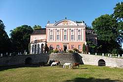
The village's history dates back to the 13th century. It had city rights from before 1400 to 1870. It has several tourist attractions, including a 14th-century palace, open for visitors, with a bison farm nearby, and a 15th-century church. The village has a population of ![]()
Some time in the mid 14th century, local knight Dobiesław of Kurozwęki built here a castle, which became the seat of the Kurozwęcki noble family (see szlachta). At first the castle was of defensive character, but in the course of the time it was remodeled several times. It is not known when exactly Kurozwęki received town charter, most probably it happened before the year 1400. The town belonged to several families – the Kurozwęcki, the Lanckoroński, the Potocki and the Popiel. In the 17th century, when Kurozwęki belonged to Lesser Poland's Sandomierz Voivodeship, it was one of the centers of Protestant Reformation, especially Calvinism. In 1870, the government of Russian-controlled Congress Poland (see Partitions of Poland) deprived it of the town charter.
Demography
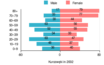
According to the 2002 Poland census, there were 844 people residing in Kurozwęki village, of whom 44.5% were male and 55.5% were female. In the village, the population was spread out with 15.9% under the age of 18, 28.6% from 18 to 44, 24.4% from 45 to 64, and 31.2% who were 65 years of age or older.[1]
Table 1. Population level of village in 2002 – by age group[1] SPECIFICATION Measure
unitPOPULATION
(by age group in 2002)TOTAL 0–9 10–19 20–29 30–39 40–49 50–59 60–69 70–79 80 + I. TOTAL person 844 76 85 110 67 107 119 74 110 96 — of which in % 100 9 10.1 13 7.9 12.7 14.1 8.8 13 11.4 1. BY SEX A. Males person 376 36 48 63 34 52 63 30 33 17 — of which in % 44.5 4.3 5.7 7.5 4 6.2 7.5 3.6 3.9 2 B. Females person 468 40 37 47 33 55 56 44 77 79 — of which in % 55.5 4.7 4.4 5.6 3.9 6.5 6.6 5.2 9.1 9.4
Figure 1. Population pyramid of village in 2002 – by age group and sex[1]
Table 2. Population level of village in 2002 – by sex[1] SPECIFICATION Measure
unitPOPULATION
(by sex in 2002)TOTAL Males Females I. TOTAL person 844 376 468 — of which in % 100 44.5 55.5 1. BY AGE GROUP A. At pre-working age person 134 69 65 — of which in % 15.9 8.2 7.7 B. At working age. grand total person 447 244 203 — of which in % 53 28.9 24.1 a. at mobile working age person 241 130 111 — of which in % 28.6 15.4 13.2 b. at non-mobile working age person 206 114 92 — of which in % 24.4 13.5 10.9 C. At post-working age person 263 63 200 — of which in % 31.2 7.5 23.7
See also
- Kurozweki Palace
References
- "Local Data Bank (Bank Danych Lokalnych) – Layout by NTS nomenclature (Układ wg klasyfikacji NTS)". demografia.stat.gov.pl: GUS. 10 March 2011.
- Bielec, Jan (ed.); Szwałek, Stanisława (1981). Wykaz urzędowych nazw miejscowości w Polsce. T. II: K – P [List of official names of localities in Poland, Vol. II: K – P] (in Polish). Ministry of Administration, Spatial Economy and Environmental Protection (1st ed.). Warsaw, Poland: Central Statistical Office.CS1 maint: extra text: authors list (link)
- Sitek, Janusz (1991). Nazwy geograficzne Rzeczypospolitej Polskiej [Geographical names of the Republic of Poland] (in Polish). Ministry of Physical Planning and Construction, Surveyor General of Poland, Council of Ministers' Office, Commission for Establishing Names of Localities and Physiographical Objects (1st ed.). Warsaw, Poland: Eugeniusz Romer State Cartographical Publishing House. ISBN 83-7000-071-1.
- "Kurozwęki, wieś, gmina Staszów – obszar wiejski, powiat staszowski, województwo świętokrzyski" [Kurozwęki, village, Staszów Commune – rural area, Staszów County, Świętokrzyskie Province, Poland]. Topographical map prepared in 1:10,000 scale. Aerial and satellite orthophotomap (in Polish). Head Office of Geodesy and Cartography, Poland, Warsaw. 2011. geoportal.gov.pl. Archived from the original on 21 December 2012. Retrieved 27 April 2011.
- "Central Statistical Office (GUS) – TERYT (National Register of Territorial Land Apportionment Journal)" (in Polish). 1 June 2008.
| Wikimedia Commons has media related to Kurozwęki. |
| Town and seat |  | |
|---|---|---|
| Parts of town |
| |
| Villages |
| |
| Parts of village |
| |
| Colonies |
| |
| Parts of colony |
| |
| Farmstead |
| |
| Hamlets |
| |
| Gamekeeper's cottage |
| |
| Forester's lodge |
| |