Koreiz
Koreiz (Ukrainian: Кореїз, Russian: Кореиз, Crimean Tatar: Koreiz) is an urban-type settlement lying south-west of Yalta in the Yalta Municipality of the Autonomous Republic of Crimea, a territory recognized by a majority of countries as part of Ukraine and incorporated by Russia as the Republic of Crimea. The name of the town means "villages" in Greek. Koreiz absorbed the nearby spa of Miskhor in 1958. Population: 5,455 (2014 Census).[2]
Koreiz Кореїз | |
|---|---|
 | |
.png) Flag  Coat of arms | |
.svg.png) Koreiz Location of Koreiz within the Crimea | |
| Coordinates: 44°25′59″N 34°5′14″E | |
| Country | Disputed between Russia and Ukraine[1] |
| Republic | Crimea |
| Municipality | Yalta Municipality |
| Local council | Koreiz |
| Elevation | 120 m (390 ft) |
| Population (2014) | |
| • Total | 5,455 |
| Time zone | UTC+4 (MSK) |
| Postal code | 98670 — 98675 |
| Area code(s) | +380-654 |
| Climate | Cfa |
Koreiz has arguably become best known as the site of two palaces:
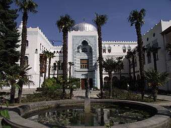
- The palace of Grand Duke Peter Nicolaievich of Russia, known as Dulber (dülber in Crimean Tatar means "beautiful"), is an asymmetrical Moorish Revival architectural extravanganza with crenellated walls, silver domes, and more than 100 rooms, inspired by the Mameluk architecture of 15th-century Cairo. This palace was built between 1895 and 1897.
- Nikolai Petrovich Krasnov , an architect who worked on the imperial Livadia Palace in nearby Yalta, built the Yusupov Palace for Prince Felix Yusupov in 1909. The palace, whose style may be described as Renaissance Revival and Roman Revival, boasts a romantic park with exotic plants and a wine cellar founded by Prince Lev Galitzine in the 19th century. After the Russian Revolution of 1917 the Soviet authorities nationalised the palace; it served as Joseph Stalin's favourite dacha during the 1945 Yalta Conference and at other times.

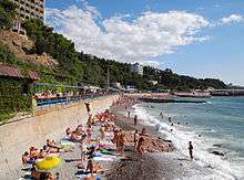 Tourism is an important sector of Koreiz's economy
References
- This place is located on the Crimean peninsula, most of which is the subject of a territorial dispute between Russia and Ukraine. According to the political division of Russia, there are federal subjects of the Russian Federation (the Republic of Crimea and the federal city of Sevastopol) located on the peninsula. According to the administrative-territorial division of Ukraine, there are the Ukrainian divisions (the Autonomous Republic of Crimea and the city with special status of Sevastopol) located on the peninsula.
- Russian Federal State Statistics Service (2014). "Таблица 1.3. Численность населения Крымского федерального округа, городских округов, муниципальных районов, городских и сельских поселений" [Table 1.3. Population of Crimean Federal District, Its Urban Okrugs, Municipal Districts, Urban and Rural Settlements]. Федеральное статистическое наблюдение «Перепись населения в Крымском федеральном округе». ("Population Census in Crimean Federal District" Federal Statistical Examination) (in Russian). Federal State Statistics Service. Retrieved January 4, 2016.
External links

| Cities | Coat of arms of Yalta Municipality | |
|---|---|---|
| Settlements | ||
| Villages | ||
This article is issued from Wikipedia. The text is licensed under Creative Commons - Attribution - Sharealike. Additional terms may apply for the media files.