Knodishall
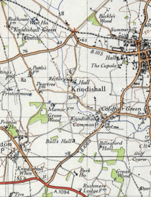
Knodishall is a village in Suffolk, England. The village is 3.5 miles (6 km) southeast of Saxmundham, and 1 mile (2 km) southwest of Leiston. It is 3 miles from the coast. Most of the village is now in Coldfair Green, with only a few houses remaining in the original village by the parish church of St Lawrence.[1]
| Knodishall | |
|---|---|
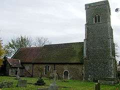 Church of St. Lawrence, Knodishall | |
 Knodishall Location within Suffolk | |
| Population | 852 2011 Census |
| Civil parish |
|
| District |
|
| Shire county | |
| Region | |
| Country | England |
| Sovereign state | United Kingdom |
| Post town | Saxmundham |
| Postcode district | IP17 |
| UK Parliament | |
It comprises a few houses clustered near the church and the hall site on gently falling land on the north side of the Hundred River valley. It is now an outlier of Knodishall Common; a larger settlement a mile to the south east.[2]
History
"Roger Bigod was the chief landholder here in 1086. Ranulf FitzWalter held 80 acres from him. Another 30 acres held by Bigod had been held before the Conquest by Edward the Confessor's free man, Boti. It had once been held by William Malet and Robert Malet held the soke. 80 acres in Knodishall formed a berewick of Roger Bigod's manor in Saxmundham. John Jenney is known to have been lord here at his death in 1460.
Benefice of Aldringham with Thorpe, Knodishall with Buxlow and Friston."[2]
According to the 2011 Census there were 418 males and 434 females living in the parish.[3] In the 1870s, Knodishall was described as:
"The parish contains also the village of Coldfair-Green, and the quondam parish of Buxlow; and is sometimes called Knodishall-cum-Buxlow. Acres 1,143. Real property, £3,173. Pop., 442. Houses, 100. The property is divided among a few. There are clay and sand pits. The living is a rectory, united with the chapelry of Buxlow, in the diocese of Norwich."[4]
In 1865 the parish of Buxlow became part of Knodishall and was then known as Knodishall-cum-Buxlow.[5]
Church
The parish church, dedicated to St Lawrence, is located a mile west of the parish of Knodishall, at the top of a hill. There is no recorded date of foundation. It was a possession of the original Leiston Abbey (at Eastbridge, founded 1182) when Robert, probably the first abbot, conceded it to the canons of Butley Priory in exchange for the churches of St Andrew at Aldringham and St Margaret at Leiston.[6] The parish register begins in 1566.[7] The fabric of the nave is of Norman date, with later medieval stained glass windows. The 15th century tower has flint facings and was restored in the 19th century: it has one bell.[5] The vestry was added in 1838. The church also has a cemetery.[8] On 7 December 1966, the Church of St Lawrence became a Grade II* British listed building.[9]
Community
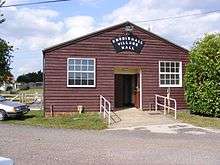
The village is dispersed and close to both Leiston and Aldeburgh. It has a village shop, the Butchers Arms pub, a smallholding, a garage and Coldfair Green Primary School. The village expanded with the building of a small housing estate in the mid 1980s. There is also a local history group on Facebook, that is gathering information from the different families in the parish.
"Knodishall Local History Group is now [2017] in its fifth year. With the help of local people we have amassed a large digital collection of photos, audio recordings and documents relating to the village."[10]
Demographics
Population
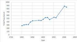
The total population of Knodishall from 1801 to 2011 has gradually increased. in 1801 the total population was just under 300 people and a slow increase until 1961 of just over 500 people.[11] Then there is a much steeper increase between 1961 and 2001 of around 400 more people, as we do not have any census data between 1961 and 2001. Even though in 1865 when the parish of Buxlow became part of Knodishall there was no significant increase in total population to show this boundary change in the following census year.
Ethnicity
Out of the 852 people living in Knodishall, 846 of them are white and are English, Welsh, Scottish, Northern Irish, British, or other. There is one person who is mixed race of white and black Caribbean. The area and surrounding areas are all predominantly white.[12]
Industry
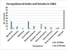
In the 1880s the main industries that people worked in were agriculture and dealing with commodities. These were mainly male dominated as were most industries at that time. However, domestic services had the most women and no men worked in domestic services[13] as shown in the graph opposite. There is also a clear trend that many females did not have jobs and were most likely taking care of the household.
| Industry | Males[14] | Females[15] | Total[16] |
|---|---|---|---|
| Agriculture | 7 | 2 | 9 |
| Construction | 39 | 5 | 44 |
| Retail and repair of motor vehicles | 32 | 20 | 52 |
| Accommodation and Catering | 13 | 22 | 35 |
| Education | 6 | 27 | 33 |
| Human health and Social Work | 8 | 35 | 43 |
| Manufacturing | 18 | 6 | 24 |
(The table above shows the raw number of males and females aged 16 to 74 in employment in Knodishall from the 2011 census.)
Now in the 21st century, according to the 2011 census, the main occupations in Knodishall are retail and repair of motor vehicles and motor cycles; human health and social work; construction and education. Most of these are still male dominated,[14] however, accommodation and catering; human health and social work; and education are female dominated.[15]
See also
References
- St Lawrence, Knodishall, Suffolk Churches website, July 2010. Retrieved 31 March 2011
- "St Lawrence, Knodishall, Suffolk". Retrieved 21 March 2017.
- "Knodishall (Parish): Key Figures for 2011 Census: Key Statistics". Neighbourhood Statistics. Office for National Statistics. Retrieved 2 February 2017.
- Wilson, John Marius (1870–72). Imperial Gazetteer of England and Wales. Edinburgh: A. Fulerton &Co.
- "History of Suffolk – Knodishall 1865". Retrieved 21 March 2017.
- W.U.S. Glanville-Richards, Records of the Anglo-Norman house of Glanville, from A.D. 1050 to 1880 (Mitchell and Hughes, London 1882), pp. 38-42 (pdf pp. 61-65).
- "St Lawrence, Knodishall (Knoddishall), Church of England". Retrieved 21 March 2017.
- GENUKI. "Knodishall". Retrieved 21 March 2017.
- Stuff, Good. "Church of St Lawrence, Knodishall, Suffolk". britishlistedbuildings.co.uk. Retrieved 30 March 2017.
- "Knodishall Parish Newsletter, Winter 2017" (PDF). Knodishall Parish Council. Retrieved 10 February 2019.
- "Knodishall AP/CP Population Statistics, Total Population". visionofbritain.org.uk. Retrieved 30 March 2017.
- Sillitoe, Neil (14 April 2008). "Ethnic Group, 2011 (KS201EW)". neighbourhood.statistics.gov.uk. Retrieved 1 May 2017.
- Vision of Britain. "Vision of Britain- 1881 Census: Ages, Table 10". visionofbritain.org.uk. Retrieved 2 April 2017.
- Sillitoe, Neighbourhood Statistics – Neil (14 April 2008). "Industry – Males, 2011 (KS606EW)". neighbourhood.statistics.gov.uk. Retrieved 2 April 2017.
- Sillitoe, Neighbourhood Statistics – Neil (14 April 2008). "Industry – Females, 2011 (KS607EW)". neighbourhood.statistics.gov.uk. Retrieved 2 April 2017.
- Sillitoe, Neighbourhood Statistics – Neil (14 April 2008). "Industry, 2011 (KS605EW)". neighbourhood.statistics.gov.uk. Retrieved 2 April 2017.
| Wikimedia Commons has media related to Knodishall. |
| Boroughs or districts |
|
|---|---|
| Major settlements |
|
| Topics | |