Knockanore Mountain
Knockanore Mountain (Irish: Cnoc an Fhómhair, meaning "hill of the autumn")[2] is a large hill North Kerry, Ireland.
| Knockanore Mountain | |
|---|---|
| Cnoc an Fhómhair | |
 The trig point on Knockanore Mountain | |
| Highest point | |
| Elevation | 267 m (876 ft) [1] |
| Prominence | 252 m (827 ft) [1] |
| Listing | Marilyn |
| Coordinates | 52°31′27.35″N 9°36′24.01″W [1] |
| Naming | |
| English translation | Hill of the autumn |
| Language of name | Irish |
| Geography | |
 Knockanore Mountain | |
| OSI/OSNI grid | Q910425 |
| Geology | |
| Mountain type | mudstone, siltstone, sandstone |
Geography
The 267-metre (876 ft) high hill stands around 5 km NE from Ballybunion. Its top hosts some broadcasting mats and a triangulation station. The hill is visible in the distance[3] and the summit offers a good view on Shannon Estuary and a large part of Kerry's Atlantic coastline.
Name
The English meaning of Cnoc an Fhómhair is hill of the autumn.
Access to the summit
Knockanore summit can be accessed by a very short walk from the nearest road.
Nature
The bogs surrounding the Knockanore are cited on The Irish naturalist, and are considered very interesting from the entomologist's point of view.[4]
See also
- List of Marilyns in Ireland
References
- "North Kerry Area - Knockanore". MountainViews. Ordnance Survey Ireland. Retrieved July 8, 2015.
- "Cnoc an Fhómhair". Placenames Database of Ireland. Dublin City University. Retrieved July 8, 2015.
- Dennis Ford. Eight Generations: the story of our family. p. 56. Retrieved July 8, 2015.
- The Irish naturalist. 7–8. 1898. p. 66. Retrieved July 8, 2015.
Mountains and hills of Munster | |||||||
|---|---|---|---|---|---|---|---|
| Ballyhoura Mountains | 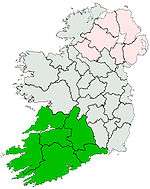 | ||||||
| Boggeragh Mountains | |||||||
| Caha Mountains | |||||||
| Comeragh Mountains | |||||||
| Derrynasaggart Mountains | |||||||
| Dingle Peninsula |
| ||||||
| Galty Mountains | |||||||
| Iveragh Peninsula | |||||||
| Knockmealdown Mountains | |||||||
| MacGillycuddy's Reeks |
| ||||||
| Mangerton Mountains | |||||||
| Shehy Mountains | |||||||
| Silvermine Mountains | |||||||
| Slieve Miskish Mountains | |||||||
| Others |
| ||||||
This article is issued from Wikipedia. The text is licensed under Creative Commons - Attribution - Sharealike. Additional terms may apply for the media files.