Kiev Voivodeship
The Kiev Voivodeship[1] (Polish: Województwo kijowskie, Ukrainian: Київське воєводство, Kyivske voyevodstvo) was a unit of administrative division and local government in the Grand Duchy of Lithuania from 1471 until 1569 and of the Crown of the Kingdom of Poland from 1569 until 1793, as part of Lesser Poland Province of the Polish Crown.
| Kiev Voivodeship Palatinatus Kioviensis Województwo kijowskie | |||||||||||
|---|---|---|---|---|---|---|---|---|---|---|---|
| Voivodeship of Polish-Lithuanian Commonwealth¹ | |||||||||||
| 1471–1793 | |||||||||||
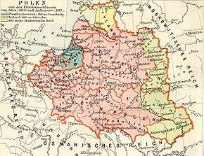
 The Kiev Voivodeship in the Polish-Lithuanian Commonwealth in 1635. | |||||||||||
| Capital | Kijów (1471–1667), Żytomierz (1667–1793) | ||||||||||
| Area | |||||||||||
• 1793 | 200,000 km2 (77,000 sq mi) | ||||||||||
| Population | |||||||||||
• 1793 | 500000 | ||||||||||
| Government | |||||||||||
| Voivode | |||||||||||
• 1471–1475 | Martynas Goštautas (first) | ||||||||||
• 1559–1608 | Konstanty Wasyl Ostrogski (transition) | ||||||||||
• 1791–1793 | Antoni Protazy Potocki (last) | ||||||||||
| History | |||||||||||
• death of Simeon Olelkovich | 1471 | ||||||||||
• 2nd Muscovite–Lithuanian War | 1503 | ||||||||||
| 1569 | |||||||||||
| 1648 | |||||||||||
| 1667 | |||||||||||
• Second partition | 1793 | ||||||||||
| Political subdivisions | counties: 9 (1471–1569) 7 (1569–1667) 3 (1667–1793) | ||||||||||
| |||||||||||
| ¹ Voivodeship of the Kingdom of Poland. The kingdom was part of the Polish-Lithuanian Commonwealth from 1569. | |||||||||||

The voivodeship was established in 1471 upon the death of the last prince of Kiev Simeon Olelkovich and transformation of Duchy of Kiev (appanage duchy of the Grand Duchy of Lithuania) into Voivodeship of Kiov (Kiovien Voivodeship).
Description
The voivodeship was established in 1471 under the order of King Casimir IV Jagiellon soon after the death of Semen Olelkovich. It had replaced the former Principality of Kiev, ruled by Lithuanian-Ruthenian Olelkovich princes (related to House of Algirdas and Olshansky family).[2][3]
Its first administrative center was Kiev, but when the city was given to Imperial Russia in 1667 by Treaty of Andrusovo, the capital moved to Zhytomyr (Polish: Żytomierz), where it remained until 1793.
It was the biggest voivodeship of the Polish-Lithuanian Commonwealth by land area, covering, among others, the land of Zaporizhian Cossacks.
Municipal government
The governor of the voivodeship was voivode (voivode of Kiev).[4] In the Polish-Lithuanian Commonwealth the other two major administrative positions were castellan[5] and bishop (biskup kijowski).
- Voivode of Kijow
- Castellan of Kijow (city governor)
- Vogt of Kijow (also see Mayor of Kiev)
Flag and coat of arms
The flag on one side had Lithuanian Pogon on red field and on other side black bear on white field with his front left paw raised up.[6]
Administrative division
Counties
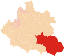
- Kijow County, Kijow (Biała Cerkiew since 1659)
- Owrucz County, Owrucz
- Zytomierz County, Zytomierz
Other former counties
- Putywl County, Putywl (lost after the second Muscovite–Lithuanian War)
- Mozyrz County, Mozyrz (transferred to Minsk Voivodeship under the Union of Lublin)
- Czerkasy County, Czerkasy (liquidated in 1566)
- Czarnobyl County, Czarnobyl (liquidated in 1566)
Former counties lost under the Treaty of Andrusovo
Elderships (Starostwo)
Instead of some liquidated counties in 1566 there were established elderships: Biała Cerkiew, Kaniów, Korsun, Romanówka, Czerkasy, Czigrin.
Neighbouring Voivodeships and regions
See also
References
- Kyiv voivodeship in the Encyclopedia of Ukraine
- "Lithuanian History" (PDF). Archived from the original (PDF) on 30 May 2008. Retrieved 24 July 2008.
- http://izbornyk.org.ua/dynasty/dyn.htm
- Polish: wojewoda kijowski
- Polish: kasztelan kijowski
- Województwo Kijowskie.
- Polish: sejmik generalny
- Polish: sejmik poselski i deputacki
Further reading
- Central European Superpower, Henryk Litwin, BUM Magazine, October 2016.
- (in Polish) Spisy pod red. Antoniego Gąsiorowskiego, t. III: Ziemie Ruskie, z. 4: Urzędnicy województw kijowskiego i czernihowskiego XV-XVIII wieku, opracowali Eugeniusz Janas i Witold Kłaczewski, Kórnik: Biblioteka Kórnicka. 2002. 343, ISBN 83-85213-37-6.
- (in Polish) Witold Bobiński. Województwo kijowskie w czasach Zygmunta III Wazy: studium osadnictwa i stosunków własności ziemskiej. Warszawa. 2000.
- (in Polish) Henryk Litwin. Napływ szlachty polskiej na Ukrainę 1569–1648. Semper. 2000. ISBN 83-86951-67-2 [also:] The Spatial Structure of the Kiev Voivodeship and its Impact on the Political and Social Life of the Gentry in 1569–1648. Struktura przestrzenna województwa kijowskiego i jej wpływ na życie polityczne i społeczne szlachty w latach 1569–1648.
- (in Polish) Michał Kulecki. Wygnańcy ze Wschodu. Egzulanci w Rzeczypospolitej w ostatnich latach panowania Jana Kazimierza i za panowania Michała Korybuta Wiśniowieckiego. Warszawa 1997. ISBN 83-7181-001-6.
- (in Polish) Dzieje rezydencji na dawnych kresach Rzeczypospolitej. Województwo kijowskie . OSSOLINEUM. 1997. ISBN 83-04-04369-6
- (in Polish) Zygmunt Gloger. Geografia historyczna ziem dawnej Polski. Kraków. 1903.
- (in Polish) Antoni Józef Rolle. Z przeszłości Polesia Kijowskiego. Warszawa. Red. Biblioteki Warszawskiej. 1882
External links
| Wikimedia Commons has media related to Kiev Voivodeship (1471-1793). |
- Kyiv voivodeship in the Encyclopedia of Ukraine
- Cossack era on Ukrainian Government portal
- The Zaphorozian Cossacks
- (in Polish) Województwo kijowskie [in:] Geographical Dictionary of the Kingdom of Poland and other slavic lands
- Palatinatus Kioviensis Pars. Boristhenem alias Dzikie Pola. .by Joannis Janssonii. Amsterdam. 1663.
- (in German) Der königlichen Republik Polen Woiwodschaft Kiow das ist die obere Polnische Ukraine oder Klein Polens oestlicher Theil. Nor. 46 Vienna. Franz Johann Josef von Reilly 1791
- (in Ukrainian) Kiev Voivodeship in the Encyclopedia of History of Ukraine
Voivodes of Kiev | ||
|---|---|---|
| Grand Duchy of Lithuania |
|  |
| Lesser Poland Province |
| |
 |
| |
| ||
Administrative division of the Polish–Lithuanian Commonwealth | ||
|---|---|---|
| Province of Greater Poland | 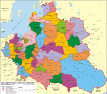 | |
| Province of Lesser Poland | ||
| Grand Duchy of Lithuania | ||
| Polish Livonia | ||
| Fiefs | ||