Kew Gardens station (LIRR)
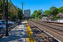
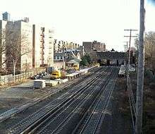
Kew Gardens is a station on the Main Line of the Long Island Rail Road (LIRR). It is located in the Kew Gardens neighborhood of Queens, New York City, near Austin Street and Lefferts Boulevard. The station is located within the City Terminal Zone, part of LIRR fare zone 1. It contains four tracks and two side platforms for the outermost tracks.
Kew Gardens | |||||||||||||||||||||||||||||||||||||||||||||||||||||||||||||||||||||||||||||||||||||||||||||||||||||
|---|---|---|---|---|---|---|---|---|---|---|---|---|---|---|---|---|---|---|---|---|---|---|---|---|---|---|---|---|---|---|---|---|---|---|---|---|---|---|---|---|---|---|---|---|---|---|---|---|---|---|---|---|---|---|---|---|---|---|---|---|---|---|---|---|---|---|---|---|---|---|---|---|---|---|---|---|---|---|---|---|---|---|---|---|---|---|---|---|---|---|---|---|---|---|---|---|---|---|---|---|---|
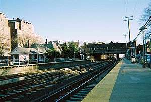 The Kew Gardens station and the Lefferts Boulevard Bridge as seen from the eastbound platform. | |||||||||||||||||||||||||||||||||||||||||||||||||||||||||||||||||||||||||||||||||||||||||||||||||||||
| Location | Austin Street and Lefferts Boulevard Kew Gardens, Queens, New York | ||||||||||||||||||||||||||||||||||||||||||||||||||||||||||||||||||||||||||||||||||||||||||||||||||||
| Coordinates | 40.7096°N 73.83066°W | ||||||||||||||||||||||||||||||||||||||||||||||||||||||||||||||||||||||||||||||||||||||||||||||||||||
| Owned by | Long Island Rail Road | ||||||||||||||||||||||||||||||||||||||||||||||||||||||||||||||||||||||||||||||||||||||||||||||||||||
| Line(s) | Main Line | ||||||||||||||||||||||||||||||||||||||||||||||||||||||||||||||||||||||||||||||||||||||||||||||||||||
| Platforms | 2 side platforms | ||||||||||||||||||||||||||||||||||||||||||||||||||||||||||||||||||||||||||||||||||||||||||||||||||||
| Tracks | 4 | ||||||||||||||||||||||||||||||||||||||||||||||||||||||||||||||||||||||||||||||||||||||||||||||||||||
| Connections | (Q37 at 80th Road and Austin Street)[1] | ||||||||||||||||||||||||||||||||||||||||||||||||||||||||||||||||||||||||||||||||||||||||||||||||||||
| Construction | |||||||||||||||||||||||||||||||||||||||||||||||||||||||||||||||||||||||||||||||||||||||||||||||||||||
| Parking | Yes | ||||||||||||||||||||||||||||||||||||||||||||||||||||||||||||||||||||||||||||||||||||||||||||||||||||
| Bicycle facilities | Bike racks (westbound platform) | ||||||||||||||||||||||||||||||||||||||||||||||||||||||||||||||||||||||||||||||||||||||||||||||||||||
| Other information | |||||||||||||||||||||||||||||||||||||||||||||||||||||||||||||||||||||||||||||||||||||||||||||||||||||
| Fare zone | 1[2] | ||||||||||||||||||||||||||||||||||||||||||||||||||||||||||||||||||||||||||||||||||||||||||||||||||||
| History | |||||||||||||||||||||||||||||||||||||||||||||||||||||||||||||||||||||||||||||||||||||||||||||||||||||
| Opened | 1879, 1883 | ||||||||||||||||||||||||||||||||||||||||||||||||||||||||||||||||||||||||||||||||||||||||||||||||||||
| Closed | 1882, 1909 | ||||||||||||||||||||||||||||||||||||||||||||||||||||||||||||||||||||||||||||||||||||||||||||||||||||
| Rebuilt | September 8, 1910[3]:26[4] | ||||||||||||||||||||||||||||||||||||||||||||||||||||||||||||||||||||||||||||||||||||||||||||||||||||
| Electrified | June 23, 1910 750 V (DC) third rail[5]:74 | ||||||||||||||||||||||||||||||||||||||||||||||||||||||||||||||||||||||||||||||||||||||||||||||||||||
| Previous names | Maple Grove (1879–1910) Kew (1910–1912) | ||||||||||||||||||||||||||||||||||||||||||||||||||||||||||||||||||||||||||||||||||||||||||||||||||||
| Traffic | |||||||||||||||||||||||||||||||||||||||||||||||||||||||||||||||||||||||||||||||||||||||||||||||||||||
| Passengers (2017) | 1,778 (Daily)[6] | ||||||||||||||||||||||||||||||||||||||||||||||||||||||||||||||||||||||||||||||||||||||||||||||||||||
| Services | |||||||||||||||||||||||||||||||||||||||||||||||||||||||||||||||||||||||||||||||||||||||||||||||||||||
| |||||||||||||||||||||||||||||||||||||||||||||||||||||||||||||||||||||||||||||||||||||||||||||||||||||
| Former services | |||||||||||||||||||||||||||||||||||||||||||||||||||||||||||||||||||||||||||||||||||||||||||||||||||||
| |||||||||||||||||||||||||||||||||||||||||||||||||||||||||||||||||||||||||||||||||||||||||||||||||||||
| |||||||||||||||||||||||||||||||||||||||||||||||||||||||||||||||||||||||||||||||||||||||||||||||||||||
The Kew Gardens station was built on the site of a station named Hopedale, which operated from 1875 to 1884 and served the Maple Grove Cemetery nearby. Another station named Maple Grove was built even closer to the cemetery in 1879. The station closed in 1909 as the LIRR was rerouted onto a more direct alignment with the construction of the Maple Grove Cut-Off. Maple Grove was replaced by the current Kew Gardens station in 1910. The station's opening played an integral part in the construction of the community of Kew Gardens. The Kew Gardens train crash took place east of the station on November 22, 1950, which killed 78 people and injured 363 others in the worst crash in the LIRR's history.
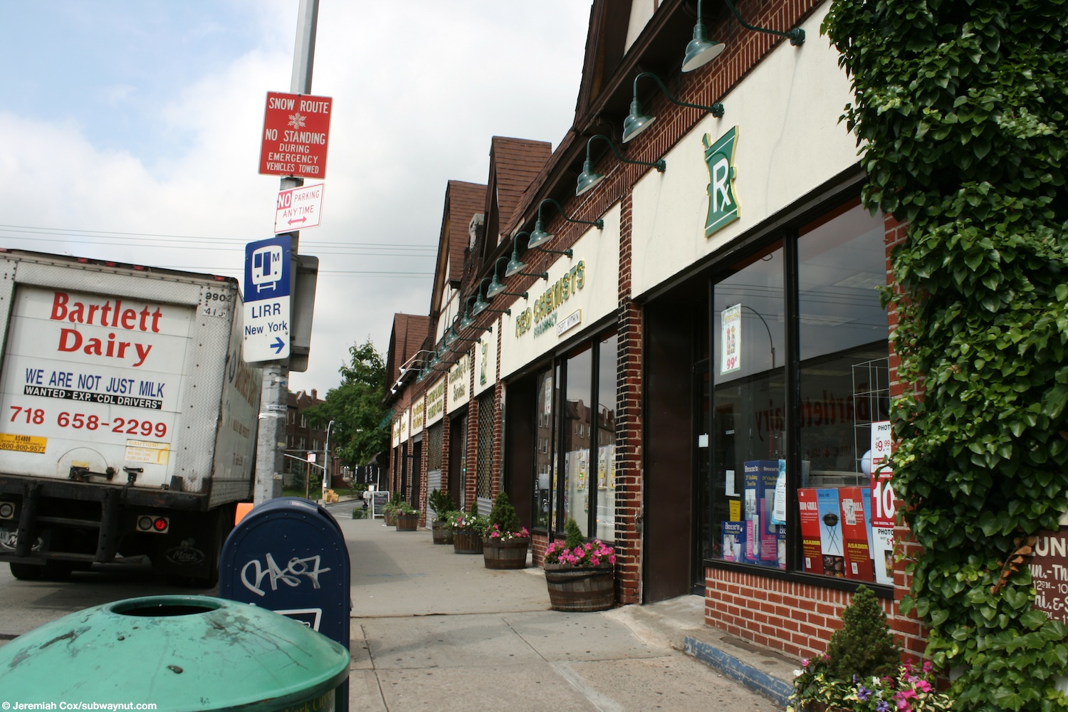
One of the Kew Gardens station's unique features is the Lefferts Boulevard Bridge, which has one story commercial buildings on both sides for local businesses. The stores were built over the tracks in 1930. While the neighborhood's charm has been attributed to the bridge, it has been under threat of demolition multiple times. Since the bridge is deteriorating, the Metropolitan Transportation Authority (MTA), which operates the LIRR, had proposed demolishing the bridge. However, the bridge was saved after local residents and politicians strongly opposed demolition.
History
Hopedale station
The first station in the vicinity of the current Kew Gardens station was known as Hopedale, and was located opposite Hopedale Hall on Union Turnpike to the west of Queens Boulevard in the hamlet with the same name.[7] The station was established in July 1875 to serve the newly opened Maple Grove Cemetery.[8][9]:165[10] The station building, whose construction was funded by the people of Richmond Hill and Whitepot (modern-day Forest Hills), was built in October 1875. Trains started stopping here on November 15, 1875, and the station was first listed on the timetable of May 1877 which showed three daily trains going west and one daily train going east.[11]:186[12] As part of a major refurbishment of the railroad, the rails from Hopedale to Jamaica were replaced in March 1879.[11]:155
This station was used by passengers going to the nearby Maple Grove Cemetery, until the Maple Grove station, which was only 0.25 miles (0.4 km) away from the cemetery, opened.[13] Due to the opening of the Maple Grove station and the planned construction of a second track, the station was closed by August 28, 1884, and its building was purchased by John Burdett, relocated, and converted into a private residence.[14]:53–54[15]
Maple Grove station
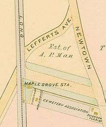
In order to better serve Maple Grove Cemetery, a new station was opened at Maple Grove, near the cemetery's western entrance. This station opened in May 1879.[16][17] The station was a flag stop, with trains only stopping upon request.[18] Funeral trains also served the station, and received special rates.[19] It had low-level platforms located to the rear of where the Mowbray and Kew Gardens Plaza Apartments are located today.[18] The eastbound platform had a station building which was designed by James Ware.[20]:59 To the west of the station, there was a grade crossing with Lefferts Avenue (now Lefferts Boulevard).[21] In summer 1879, a new depot was installed at the station, which opened up to a new western entrance to the cemetery.[22]
On January 1, 1881, Austin Corbin took over the Long Island Rail Road and sought out to install new rails on the Main Line from Winfield Junction to Jamaica. In February 1881, all service on the Main Line was halted, and this station was temporarily abandoned at this time. Starting in April, the old rails were torn up and used on the South Side Railroad of Long Island.[23]:140–141 The temporary abandonment inconvenienced visitors to the Cemetery, and during this period, the managers of the cemetery made arrangements to have visitors transported free of charge to the Richmond Hill station on the Montauk Division.[19]
The tracks were relaid during September and October 1882, and the line was rebuilt as a double-track line with iron rails. The line was reopened on October 25, 1882 for freight only to allow the Montauk Division to be exclusively used for passenger service.[23]:114, 115, 120[24]:87 Service resumed on May 30, 1883 with one daily train in each direction after the managers of the Cemetery made a request to the directors of the Long Island Rail Road.[25][26] In 1886, the station was moved 40 feet (12 m) to provide space for a lawn and flowerbed.[3]:11
After Hopedale station closed in 1884, this was the only station on the Main Line between Winfield and Jamaica, and as of 1897, the line was mostly used for freight, with the exception of some passenger service during commuting hours.[27] In 1888, commutation fares were not offered for the station, the fare to New York was 25 cents, and the station was served by three daily eastbound trains and one daily westbound train. At the time, there were two nearby bridges over roadways spanned by pratt trusses and wood track stringers.[28] While this was originally a single-tracked line, it was double-tracked between 1888 and November 1902.[lower-alpha 1] As part of the construction of the Maple Grove Cut-Off, the station was removed in 1909, and replaced by Kew station in 1910.[14]:69
Maple Grove Cut-Off
In order to provide fast service for the opening of the Pennsylvania Railroad's East River Tunnels in 1910, the Long Island Rail Road completely rebuilt the Main Line between Winfield and Jamaica from one track to four tracks, with two additional tracks between the Glendale Cut-Off and Winfield. 40 grade crossings were eliminated as part of the project.[30][31] In addition, the line was electrified using a third rail. This was expected to reduce the running time between Jamaica and Sunnyside Yard from 18 minutes to 12 minutes.[32]
To speed up service through Kew Gardens, the LIRR undertook the construction of the Maple Grove Cut-Off for $500,000.[33][5] The Cut-Off shortened the Main Line by 328 feet (100 m),[4] and sped up service with the construction of a new straightened four-track route that ran at a lower grade. The Cut-Off branched from the original line about 400 feet (120 m) north of Ascan Avenue in Forest Hills, and continued to 84th Drive in Kew Gardens, or about 700 feet (210 m) east of Lefferts Avenue. The original line ran straight from Winfield to within a few feet of Queens Boulevard at Lefferts Avenue (now Boulevard) and then curved sharply southeast around the southern edge of Maple Grove Cemetery, slowing service.[20]:40
The land for the right-of-way to the west of Lefferts Avenue was acquired from the Cord Meyer Development Corporation, while the land to the east was purchased from Alrick Man, the founder of the urban neighborhood of Richmond Hill. While he had to sell the property of the Richmond Hill Golf Club and 25 acres of estate, he still owned a lot of the land in Richmond Hill, and therefore financially benefitted from the move. Since the golf course was going to be cut in half by the railroad, Man closed the course in 1906, and decided to sell the course and turn it into a residential community.[9]:165 The right-of-way initially had room for six tracks, of which four tracks were built.[34] The two additional tracks would have been used for freight. The LIRR's right-of-way increased from 50 to 60 feet (15 to 18 m) to 150 feet (46 m).[35] Crystal Lake, which was in the path of the Cut-Off, was drained in 1909.[20]:39[36]:138–139 As part of the initial agreement, bridges over the new right-of-way were to be built over Quentin Road (now 80th Road) and Lefferts Avenue.[37]
The Maple Grove station was moved from its location 500 feet (150 m) south of Kew Gardens Road (old Newtown Avenue) to a spot 600 feet (180 m) south along the north side of tracks on the west side of Lefferts Avenue, closer to the built-up portion of Richmond Hill. Man built streets through the property of the old golf club, and built elegant homes close to the new railroad station, creating what is known as Kew Gardens today.[5] On November 20, 1908, the New York Public Service Commission approved the LIRR's application to complete the Maple Grove Cut-Off.[38]
Limited construction began on the Cut-Off in November 1908, with real work beginning in March 1909.[5] On December 4, 1908, the New York City Board of Estimate approved the plans for bridges at Union Turnpike and Ascan Avenue, but did not approve the plans for the bridge carrying Quentin Road and Lefferts Avenue over the line as these streets were not yet included on the city's map.[39] The plans were modified in 1909 to add bridges at Penelope Avenue and Ascan Avenue. The grading of the right-of-way and the laying of track was completed by September 1909.[5] On July 26, 1909, eastbound trains started running over the Maple Grove Cut-Off.[40] On July 30, westbound trains began running via the cut-off with its completion.[32] Following the completion of the Cut-Off, riders who patronized the Richmond Hill station on the Montauk Division were concerned that passenger service to their station would be discontinued, requiring them to use the station replacing Maple Grove on the Main Line. The LIRR stated that the station would continue to receive service.[41]
Provisions were left for future crossings at Roman Avenue (72nd Avenue), Puritan Avenue (75th Avenue), and Allegheny Avenue (77th Avenue).[37] The floor system of the Union Turnpike bridge was designed to allow for two trolley tracks to pass over it.[39] All of the bridges completed as part of the project were constructed with concrete floors, heavy steel girders, and watertight steel.[42]
As part of the agreement with the Long Island Rail Road, the property occupied by the old right-of-way was transferred to Cord Meyer and Alrick Man.[38] The old railroad right-of-way was built up with residences,[43] but in 1936, portions of the right-of-way within Forest Hills, around Austin Street and 75th Avenue, were still unused.[44][45]
Kew Gardens station
On September 8, 1910, the new Kew station opened along with the introduction of electric service to Penn Station using the Maple Grove Cut-Off.[3]:26[4] The first train left the station at 4:14 a.m. The first passenger boarding at Kew was also the first passenger to pass through the gates at Penn Station[46] The new station was 108 feet (33 m) long and its station building was built as a one-story structure made of terra cotta and stucco. It was built in the fall of 1909.[47] The station's quick access to Manhattan (15 minutes) was used by the Kew Gardens Corporation in advertisements to convince buyers to move to the community.[9]:165 Service initially consisted of more than twenty daily trains in each direction, with many trains running nonstop to Penn Station owing to the railroad's franchise which prohibited passenger stations within 5 miles (8.0 km) of Penn Station. In anticipation of the demand for housing in the community, the Haugaard brothers purchased land from the Man estate and built several houses within a few minutes of the station.[48] Between 1910 and 1911 38 buildings were built in the community.[49]:57
The old station building for Maple Grove was moved approximately 600 feet (180 m) south alongside and perpendicular to the tracks for use as a real estate office of developers of Kew, but was razed a short time later. Prior to the opening of the new station, and the development accompanying it, the station was referred to as North Richmond Hill,[35] but was named Kew after residents and the Long Island Rail Road requested that the name be changed to avoid confusion.[50] Soon after, in 1912, the station was renamed Kew Gardens.[14]:60 This name was chosen as it was the name of an adjacent town to Richmond Hill, England, which was the ancestral home of Alrick Man.[20]:41
On July 1, 1914, the Hillside Transportation Company began running a bus line along Lefferts Avenue connecting Kew Gardens station with Morris Park station.[51] In October 1923, the LIRR finished a project extending one of the platforms in the station to the west.[52] On December 19, 1928, the New York State Transit Commission ordered the LIRR to increase service at Kew Gardens and to lengthen the westbound platform to eleven cars.[53] The LIRR agreed to extend the platform on January 10, 1929.[54] The platform was lengthened in 1929.[55]:16, 57 At some point, the eastbound platform was lengthened.[21] With the extension of the Independent Subway System's Queens Boulevard Line to Kew Gardens on December 31, 1936,[56] ridership at this station decreased,[57]:94 with the downturn noticed as early as July 1937.[58]
The Kew Gardens station became the site of the worst accident in the histories of both the Long Island Rail Road and New York State. On November 22, 1950, a collision between two Long Island Rail Road commuter trains to the east of the station killed 79 people and injured hundreds.[59][60] This occurred nine months after a collision at Rockville Centre station on February 17, 1950, which resulted in the deaths of 32 people and the serious injury of 158 people.[61] Another notorious historical aspect is the 1964 murder of Kitty Genovese, which occurred near the Kew Gardens station after Genovese had parked her car at its northern parking lot.[62]
On July 1, 1964, the Tri-State Transit Commission began a year-long test of a mechanical fare collection system at the westbound platforms of Kew Gardens and Forest Hills. Fencing was installed, requiring passengers to enter through the station house and then insert their magnetically encoded tickets into turnstiles.[63]
In November 1963, the LIRR announced a plan to shorten the platforms at Forest Hills and Kew Gardens by 300 feet (91 m). The railroad's justification was that ridership at the stations was low, and did not warrant repairing the crumbling concrete. These sections of platforms had been installed in about 1929 to allow the stations to accommodate full-length trains. This move was opposed by civic groups, and resulted in an investigation by the Public Service Commission.[64] However, the platform extensions were removed in 1965 or 1966. Prior to their removal, the platforms extended to the overpass at 82nd Avenue (formerly known as Onslow Place).[20]:56 A staircase from each platform allowed passengers to enter and leave the station from its western end.[21][65][66] The eastbound platform used to have a waiting room, but it was removed in the late 1970s.[20]:42 In the early 1990s, the westbound platform was extended by about 20 feet (6.1 m), doubling the number of cars that could platform at the station to four.[67]
On February 1, 1980, the LIRR, in response to audit released by the state comptroller on November 16, 1979, submitted a proposal to close 29 stations, including Kew Gardens, to save $250,000. The audit evaluated ticket sales in 1976, and recommended that stations with fewer than 60 transactions per hour be closed. Thirty-nine LIRR stations fell in to this category, but ten were not recommended for closure, either because they were terminals or switch locations. In addition to Kew Gardens, Forest Hills, East Hampton, Westhampton, Sea Cliff and Locust Valley would be completely closed. The other stations would have been closed on weekends, every day but Monday, or closed half of the day.[68]
Platform extensions
In the Metropolitan Transportation Authority (MTA)'s 2010–2014 capital program, it proposed lengthening the four-car-long platforms at Kew Gardens and Forest Hills to allow additional train cars to board at the station. The platform extensions would reduce waiting time at the station while allowing for more efficient operations between Jamaica and Penn Station. Although $4.5 million was allocated for the project, the money was ultimately redistributed to other projects.[69]:58, 186[lower-alpha 2] On July 26, 2018, it was announced that the LIRR planned to extend the platforms at Kew Gardens and Forest Hills by 200 feet (61 m) to accommodate six-car trains. The platform extensions will consist of fiberglass decking supported by steel scaffolding structures, allowing the extensions to be completed quickly, and at a low cost, while allowing the LIRR to plan for a permanent solution. Preparation work began during the week of July 23,[6] and the new extensions went into service the week of September 12, 2018.[71]
Ticket booth
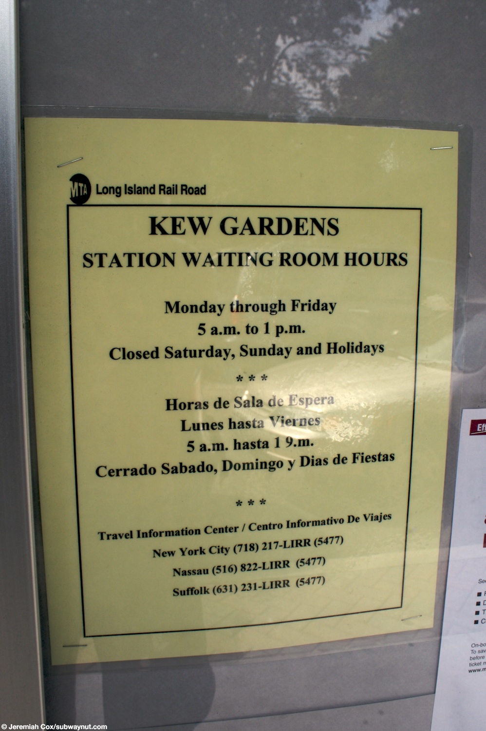
On August 19, 2009, the manned ticket booth at the station was closed along with those at 19 other stations to cut costs.[72] The ticket office had been open between 6:10 and 9 a.m.[73] In October 2012, the LIRR announced that it would extend the hours of the waiting room to 10 p.m. on weekdays as part of a pilot program.[74] The waiting room, which previously operated from 6 a.m. to 10 a.m., had its operating hours extended to between 5 a.m. and 10 p.m.[75] In late 2016, the station hours were cut back to 2 p.m.[76][77]
Lefferts Boulevard Bridge
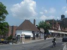
In order to pass over the Long Island Rail Road, at the eastern end of the Kew Gardens station, Lefferts Boulevard passes over on an 180 foot (55 m)-long bridge, which is lined on both sides with commercial buildings.[78] The bridge was built in 1910, and the stores on either side of the bridge, which were located on their own bridges, were constructed in the early 1930s. The bridges that hold the stores in place actually run through their roofs, with the stores hanging from the bridge. The bridge upon which Lefferts Boulevard passes over is owned by the New York City Department of Transportation (NYCDOT) while the other two bridges are owned by the LIRR and are leased to a master tenant which leases out the buildings to local businesses.[79] The building facade for the stores on the western side of the bridge is in the neo-Tudor design while the facade for the stores on the eastern side is in the Art Deco style. The bridge has been called Ponte Vecchio, meaning "old bridge" in Italian, and refers to the bridge in Florence, which has stores on either side of it.[20]:121–122 The Bridge is the heart of the community of Kew Gardens, and its residents have attributed the charm of the neighborhood to it. It is the only bridge in New York City, and likely in the United States that has stores on either side of it, and therefore many Kew Gardens residents have pushed for its designation as a landmark on the National Registry of Historical Places to protect it from development.[80]
Demolition threats
In 1991, the MTA drafted plans to build a twelve-story condominium and parking lot on top of the Kew Gardens station, which is only 100 feet (30 m) from the bridge, but withdrew them after local civic leaders fought the plan, which could have threatened the bridge.[81] In June 1991, the NYCDOT began a $2.9 million project to rebuild the concrete surface of the bridge and to replace its steel girders and deck beams. The project was scheduled to be completed in 15 months. Due to construction, sidewalks were narrowed, parking was abolished, and traffic was slowed with the roadway narrowed to two lanes. As a result, business declined at the stores on either side of the bridge, with nine of the thirteen stores on the bridge closing, even as rents were halved. However, from October 1991 to January 1992 work stopped due to a design error, which made the new girders an inch too high. Completion was then delayed by three months.[78] In 1992, the MTA ended the lease of the company that had managed the stores on the bridge since 1981 citing the company's refusal to make repairs which allowed the stores to deteriorate. The agency, for the next 14 months, rented stores, at a discounted rate, every month, as it was looking for a buyer to make repairs. The MTA did not pay for the repairs as it had more "pressing repairs" which needed to be done to keep the subway system running.[80]
In May 2017, the MTA announced that it wanted to rebuild the bridge, which runs from Austin Street to Grenfell Street. It told business owners on the bridge that their stores would be torn down once the management company's lease expired in 2020. If the bridge was rebuilt, it was unclear what would replace the existing businesses.[81] The bridge is in such bad condition that in spring 2017, a hole opened up in the storage room of the Thyme Natural Market. In response, the Save Kew Gardens Coalition was created in order to convince the MTA not to tear down the bridge. The coalition is made up of local civic groups such as the Kew Gardens Civic Association, the Kew Gardens Improvement Association and the Friends of Maple Grove Cemetery.[82] In July, in response to strong community opposition and pushback from City Council Member Karen Koslowitz and others, MTA officials changed their stance, opening up to possible ideas about how to repair the bridge decks, which are 80 years old and decaying, while keeping the businesses in place.[83] Mayor Bill de Blasio, when asked, said that he was against its demolition, and sent DOT engineers to visit the site. Also in July, three engineers, one from the NYCDOT, one from the MTA, and a retired engineer, Al Brand, determined that is might be feasible to install an additional concrete slab, which would be 12 inches (30 cm) to 14 inches (36 cm) wide, underneath the bridge. This alternative was deemed feasible.[79]
The MTA announced that an engineering feasibility study, which would be funded by Koslowitz, would be conducted, but it is unclear how much it will cost and who will conduct it.[84] Koslowitz had hoped to use $1 million to fund it, but because it is capital money, it can only be used for construction. Instead, she started looking for funding from the city and state.[85] On November 14, 2017, Queens Community Board 9 unanimously backed a resolution asking the MTA not to tear down the bridge.[86] On July 11, 2018, the LIRR announced that it planned to repair the bridge, using the funds that Koslowitz had obtained for a study.[87][88]
Platforms and tracks
The station building is located on the westbound platform and the waiting room is open weekdays from 5 a.m. to 2 p.m..[89][90] The waiting room has a bathroom.[91] A former ticket booth was located on Platform A. Two ticket machines are located adjacent to the building. The station has a small free parking lot that is open between 5 a.m. and 3 a.m., making it in the only station in the City Terminal Zone to have parking.[92][93]
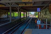
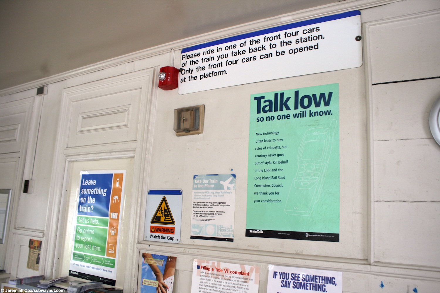
This station has two high-level side platforms each six cars long.[69][71] Generally, only the first six cars of a train in either direction will receive and discharge passengers at this station.[94] The north platform next to Track 3 is generally used by westbound or Manhattan-bound trains. The south platform next to Track 4 is generally used by eastbound or outbound trains. Most LIRR trains that pass through the station do not stop. There are no platforms on the two middle tracks, as they are used by express trains.[95] The station platforms are ADA-accessible by means of ramps. However, the station is not listed as such by the MTA; since the two platforms are disconnected, passengers who wish to cross between the two platforms must use the Lefferts Boulevard Bridge.[89][96]
| P Platform level |
Platform A, side platform | |
| Track 3 | ← Main Line services toward Penn Station (Forest Hills) | |
| Track 1 | ← Main Line services does not stop here → | |
| Track 2 | ← Main Line services does not stop here → | |
| Track 4 | Main Line services toward Jamaica and Points East (Jamaica) → | |
| Platform B, side platform | ||
| G | Street level | Entrances/exits |
Notes
References
- "Queens Bus Map" (PDF). Metropolitan Transportation Authority. December 2017. Retrieved April 24, 2018.
- "LIRR Stations and Fare Zones" (PDF). mta.info. Metropolitan Transportation Authority. March 19, 2017. Retrieved September 16, 2018.
- Cataldi, Nancy; Ballenas, Carl (November 21, 2006). Maple Grove Cemetery. Arcadia Publishing. ISBN 9781439634455.
- Emery, Robert (March 31, 2008). "LIRR Branch Notes". trainsarefun.com. Retrieved April 29, 2018.
- Seyfried, Vincent F. "Part Seven: The Age of Electrification 1901-1916". The Long Island Rail Road A Comprehensive History. pp. 150–154.
- "LIRR to Lengthen Platforms at Forest Hills and Kew Gardens". www.mta.info. Metropolitan Transportation Authority. July 27, 2018. Retrieved July 27, 2018.
- Bayles, Richard Mather (1885). Bayles' Long Island Hand Book. Budget Steam Print. p. 29.
- "The Hopedale Long Island Railroad Station". oldkewgardens.com. Kew Gardens Civic Association. Retrieved November 24, 2017.
- Seyfried, Vincent F.; Asadorian, William (1991). Old Queens, N.Y., in Early Photographs. Courier Corporation. ISBN 9780486263588.
- "Island Items". Kings County Rural Gazette. July 24, 1875. p. 3. Retrieved May 5, 2020.
- Seyfried, Vincent (1966). The Long Island Rail Road: A Comprehensive History Part Three The Age of Expansion, 1863-1880. Garden City. p. 186.
- Long Island and where to go!! A descriptive work compiled for the Long Island R. R. co. for the use and benefit of its patrons. 1877. p. 15. Retrieved October 3, 2015.
- "Maple Grove Cemetery". The Brooklyn Daily Eagle. May 26, 1879. p. 4. Retrieved November 24, 2017.
- Seyfried, Vincent; Emery, Robert; Huneke, Art; Erlitz, Jeff. "Long Island Rail Road Alphabetical Station Listing and History" (PDF). trainsarefun.com. Retrieved November 24, 2017.
- "Local" (PDF). The Newtown Register. August 28, 1884. p. 3. Retrieved November 24, 2017.
- "The Maple Grove Long Island Railroad Station". www.oldkewgardens.com. Kew Gardens Civic Association. Retrieved November 24, 2017.
- "June 15, 1879 LIRR Summer Schedule". Flickr. Long Island Rail Road. June 15, 1879. Retrieved December 31, 2018.
- "The Maple Grove Station". oldkewgardens.com. Kew Gardens Civic Association. May 6, 2010. Retrieved July 28, 2014.
- "Maple Grove. An Afternoon To The New Cemetery Grounds". Brooklyn Times Union. November 25, 1882. p. 6. Retrieved May 5, 2020.
- Ballenas, Carl (2014). Kew Gardens. Arcadia Publishing. ISBN 9781467120722.
- Emery, Robert. "Maple Grove Cut-Off Track Map Kew Gardens". lirrhistory.com. Retrieved November 24, 2017.
- "Long Island Items". Kings County Rural Gazette. December 20, 1879. p. 4. Retrieved May 5, 2020.
- Seyfried, Vincent (1975). The Long Island Rail Road: A Comprehensive History Part Six The Golden Age: 1881-1900. Vincent Seyfried.
- Baer, Christopher (November 2015). "A General Chronology Of The Pennsylvania Railroad Company Its Predecessors and Successors And Its Historical Context 1882" (PDF). prrths.com. Retrieved November 24, 2017.
- "Special Notices: Maple Grove Cemetery, Office". Brooklyn Daily Eagle. June 9, 1883. Retrieved September 16, 2018.
- "Maple Grove Cemetery". Brooklyn Times Union. May 26, 1883. p. 1. Retrieved May 5, 2020.
- Tooker, John (December 1941). "More on Forest Hills". Long Island Forum. 4 (12): 268.
- Sixth Annual Report of the Board of Railroad Commissioners of the State of New York for the Fiscal Year Ending September 30, 1888. Transmitted to the Legislature January 14, 1889. New York State Board of Railroad Commissioners. 1889. pp. 16–35, 242.
- "Long Island Rail Road Main Line Maple Grove". www.oldkewgardens.com. November 1902. Retrieved November 24, 2017.
- Minutes of the Board of Estimate and Apportionment Public Improvement Matters From January 1, 1911, To March 31, 1911. New York City Board of Estimate. 1911. p. 741.
- Company, Long Island Railroad (1912). Annual Report of the Long Island Rail Road Company to the Interstate Commerce Commission for the Year Ended December 31, 1912. Long Island Railroad Company. p. 7.
- "Cut-Off Completed". Brooklyn Times Union. August 2, 1909. p. 8. Retrieved May 6, 2020.
- "MILLIONS SPENT ON LONG ISLAND R.R.; First Full Details of Improvements and What They Have Cost the Pennsylvania". The New York Times. April 10, 1910. ISSN 0362-4331. Retrieved November 25, 2017.
- "A Picture History of Kew Gardens, NY - North of Metropolitan Avenue". www.oldkewgardens.com. Kew Gardens Civic Association. Retrieved September 16, 2018.
- "Real Rapid Transit–Magnitude of Improvements Under Way on Long Island Railroad System Affecting Richmond Hill". The Richmond Hill Record. 1907. Retrieved September 18, 2018.
- Kadinsky, Sergey (2016). Hidden Waters of New York City: A History and Guide to 101 Forgotten Lakes, Ponds, Creeks, and Streams in the Five Boroughs. Countryman Press. ISBN 978-1-58157-566-8.
- Minutes of the Board of Estimate and Apportionment of the City of New York From August 1, 1913 to October 20, 1913. New York City Board of Estimate. 1913. p. 7900.
- Proceedings of the Public Service Commission for the First District, State of New York Volume III June 2d to December 31st, 1908 (With Index of Volumes II and III). New York State Public Service Commission. 1908. pp. 1755–1757.
- Minutes of the Board of Estimate and Apportionment of The City of New York Public Improvement Matters From July 1 to December 31, 1908. New York City Board of Estimate. 1909. pp. 2491–2493.
- "Using The New Line. L.I.R.R. Trains Running Over the Maple Grove Cut-off From L.I. City to Jamaica". Brooklyn Times Union. July 27, 1909. p. 5. Retrieved May 6, 2020.
- "Richmond Hill Will Still Get Service". Brooklyn Times Union. August 6, 1909. p. 6. Retrieved May 6, 2020.
- "Shortening Distance By Cutting Out Curves. Improvements Being Undertaken on Railroad Between Jamaica and L.I. City. Glendale Cut-Off Begun. Company to Spend $2,500,000 on Line Between the Two Towns Named". The Brooklyn Daily Eagle. August 29, 1908. Retrieved May 7, 2020.
- Kadinsky, Sergey (October 10, 2017). "Crystal Lake, Queens". Hidden Waters blog. Retrieved November 25, 2017.
- Rugen, William J. (June 21, 1936). "Abandoned Right Of Way". digitalarchives.queenslibrary.org. Retrieved November 25, 2017.
- Rugen, William J. (June 21, 1936). "Abandoned Right Of Way". digitalarchives.queenslibrary.org. Retrieved November 25, 2017.
- "Mr. Kooser's Distinction". Brooklyn Daily Eagle. September 8, 1910. Retrieved September 18, 2018.
- "New Maple Grove Station". Brooklyn Daily Eagle. August 3, 1909. p. 17. Retrieved September 16, 2018.
- "Richmond Hill and Kew Gardens Fifteen Minutes from Manhattan The Backbone of Long Island Traced from 1867". Brooklyn Daily Eagle. September 8, 1910. Retrieved September 18, 2018.
- Willis, Walter I. (1913). Queens Borough; being a descriptive and illustrated book of the borough of Queens, city of Greater New York, setting forth its many advantages and possibilities as a section wherein to live, to work and succeed ... Issued by the Manufacturing and industrial committee of the Chamber of commerce of the borough of Queens;. Queens Chamber of Commerce – via The Library of Congress.
- "100 Houses Built and Sold at Kew Gardens in Eighteen Months". New York Sun. January 18, 1914. Retrieved September 18, 2018.
- "Bus Line To Run July First. Hillside Transportation Go. To Operate Busses in Richmond Hill". The Leader-Observer. June 25, 1914. Retrieved September 18, 2018.
- "New Railroad Platform at Kew". The Richmond Hill Record. October 19, 1923. Retrieved September 18, 2018.
- Eighth Annual Report 1928. Columbia University Libraries. New York State Transit Commission. 1928. pp. 125.CS1 maint: others (link)
- "L I.R.R. to Get More Steel Cars, Lengthen Platform at Kew Gardens" (PDF). The Daily Star. January 11, 1929. Retrieved September 16, 2018.
- Transit Commission Ninth Annual Report. New York State Transit Commission. 1929.
- "CITY SUBWAY OPENS QUEENS LINK TODAY; Extension Brings Kew Gardens Within 36 Minutes of 42d St. on Frequent Trains". The New York Times. December 31, 1936. ISSN 0362-4331. Retrieved April 26, 2016.
- Fischler, Stan. Long Island Rail Road. Voyageur Press. ISBN 9781616731564.
- "City Subway Hurting L. I. Road and B. M. T.; 33,000 Use 5 New Jamaica Stations Daily". The New York Times. July 7, 1937. ISSN 0362-4331. Retrieved November 25, 2017.
- "Collision". oldkewgardens.com. Kew Gardens Civic Association. May 6, 2010. Retrieved April 29, 2018.
- "About the Long Island Rail Road's Worst Train Crash". richmondhillhistory.org. Richmond Hill Historical Society. Archived from the original on March 16, 2018. Retrieved April 29, 2018.
- "Revised List of Casualties in Long Island Rail Wreck; Diagram Of Site Of Fatal Train Crash". The New York Times. February 19, 1950. ISSN 0362-4331. Retrieved April 27, 2018.
- Skoller, Charles (2013). Twisted Confessions: The True Story Behind the Kitty Genovese and Barbara Kralik Murder Trials. Author House. p. 16. ISBN 978-1-4817-4615-1.
- "Robots To Take LIRR Tix". Long Island Star-Journal. June 22, 1964. Retrieved September 18, 2018.
- "L.I.R.R. Plan to Shorten 2 Queens Platforms Scored". The New York Times. November 14, 1963. ISSN 0362-4331. Retrieved November 26, 2017.
- "Changes to the Station". www.oldkewgardens.com. Kew Gardens Civic Association. Retrieved November 24, 2017.
- Compare:
- "Aerial map of Kew Gardens LIRR station from 1954". Historic Aerials. Retrieved November 24, 2017.
- "Aerial map of Kew Gardens LIRR station from 1966". Historic Aerials. 1966. Retrieved November 24, 2017.
- Compare:
- "Aerial map of Kew Gardens LIRR station from 1980". Historic Aerials. Retrieved September 13, 2018.
- "Aerial map of Kew Gardens LIRR station from 1994". Historic Aerials. 1966. Retrieved September 13, 2018.
- Ain, Stewart (February 4, 1980). "LIRR asks closing of 29 stations". New York Daily News. Retrieved September 14, 2018.
- "Proposed 2010-2014 Capital Program" (PDF). nysenate.gov. Metropolitan Transportation Authority. September 2009. Retrieved November 24, 2017.
- "MTA Capital Program 2010-2014" (PDF). mta.info. Metropolitan Transportation Authority. July 31, 2017. Retrieved November 24, 2017.
- "LIRR Opens Longer Platforms at Forest Hills and Kew Gardens". www.mta.info. Metropolitan Transportation Authority. September 12, 2018. Retrieved September 13, 2018.
- "Agents To Be Available To Assist Customers At LIRR Stations Where Ticket Offices Are Closing August 19". mta.info. Metropolitan Transportation Authority. August 14, 2009. Retrieved September 13, 2018.
- "Ticket Sales at Kew Gardens". lirr.org. Archived from the original on April 16, 2003. Retrieved September 16, 2018.
- "The LIRR agrees to the LIRRCC's call to keep waiting rooms open later". www.pcac.org. Long Island Rail Road Commuter Council. October 3, 2012. Retrieved September 13, 2018.
- "MTA LIRR - Kew Gardens". mta.info. Metropolitan Transportation Authority. Archived from the original on May 23, 2012. Retrieved September 16, 2018.
- "MTA LIRR - Kew Gardens". mta.info. Metropolitan Transportation Authority. Archived from the original on August 16, 2016. Retrieved September 16, 2018.
- "MTA LIRR - Kew Gardens". mta.info. Metropolitan Transportation Authority. Archived from the original on December 23, 2016. Retrieved September 16, 2018.
- Fried, Joseph P. (January 26, 1992). "While Bridge Is Fixed, Businesses Waste Away". The New York Times. ISSN 0362-4331. Retrieved December 7, 2017.
- Cronin, Jon (July 13, 2017). "Engineers Help Lefferts Blvd Bridge Shop Owners". queenstribune.com. Retrieved December 7, 2017.
- Myers, Steven Lee (January 10, 1993). "Kew Gardens Sighs for Its Bridge of Stores". The New York Times. ISSN 0362-4331. Retrieved December 7, 2017.
- Barca, Christopher (May 25, 2017). "KG bridge businesses face a murky future". Queens Chronicle. Retrieved December 7, 2017.
- Barca, Christopher (June 1, 2017). "Residents back the bridge businesses". Queens Chronicle. Retrieved December 7, 2017.
- O'Reilly, Anthony (September 21, 2017). "MTA wants ideas to save the bridge". Queens Chronicle. Retrieved December 7, 2017.
- Apodaca, Gene (September 22, 2017). "MTA to conduct study to see if Kew Gardens 'bridge of businesses' can be saved". NY1 News. Retrieved December 7, 2017.
- Barca, Christopher (October 5, 2017). "Money for Kew Gardens bridge study isn't there yet". Queens Chronicle. Retrieved December 7, 2017.
- O'Reilly, Anthony (November 16, 2017). "CB 9 to MTA: Don't tear down the bridge". Queens Chronicle. Retrieved December 7, 2017.
- "LIRR to Make Structural Repairs to Lefferts Boulevard Overpass in Kew Gardens". www.mta.info. Metropolitan Transportation Authority. July 11, 2018. Retrieved September 14, 2018.
- Maslin Nir, Sarah (July 12, 2018). "A Bridge, the Rickety Heart of Kew Gardens, Gets a Reprieve". The New York Times. Retrieved September 13, 2018.
- "Kew Gardens station City Zone Branch - Fare Zone 1". mta.info. Metropolitan Transportation Authority. Retrieved September 13, 2018.
- Cox, Jeremiah (June 13, 2011). "Waiting room hours". subwaynut.com. Retrieved September 13, 2018.
- "LIRR Station Leasing" (PDF). Cushman & Wakefield. 2018. Retrieved May 3, 2020.
- "Parking, Bus and Taxi Information Kew Gardens Station" (PDF). mta.info. Metropolitan Transportation Authority. May 2017. Retrieved September 13, 2018.
- "LIRR Parking Lot Information". mta.info. Metropolitan Transportation Authority. Retrieved September 13, 2018.
- Cox, Jeremiah (June 13, 2011). "Signage directing passengers to make sure there in the first four cars on their return journey". subwaynut.com. Retrieved September 13, 2018.
- Green, Richard E. (2007). "Long Island Rail Road Track Map V3" (PDF). usew.net. Archived from the original (PDF) on July 2, 2017. Retrieved December 7, 2017.
- Cox, Jeremiah (June 13, 2011). "The shopping arcade above the railroad tracks". subwaynut.com. Retrieved September 13, 2018.