Kamianets-Podilskyi Raion
Kamianets-Podilskyi Raion (Ukrainian: Кам'янець-Подільський район, Kam'ianets'-Podil's'kyi raion) is one of the 20 administrative raions (a district) of the Khmelnytskyi Oblast in western Ukraine. Its administrative center is located in the city of Kamianets-Podilskyi, even though the city itself is not under the raion's jurisdiction. Its population was 75,506 in the 2001 Ukrainian Census[2] and 67,900 on September 9, 2012.[3]
Kamianets-Podilskyi Raion Кам'янець-Подільський район | |
|---|---|
Raion | |
 Flag  Coat of arms | |
 | |
| Coordinates: 48°40′56″N 26°34′57″E | |
| Country | |
| Region | Khmelnytskyi Oblast |
| Established | March 7, 1923 |
| Admin. center | Kamianets-Podilskyi |
| Subdivisions | List
|
| Government | |
| • Governor | Mykhailo Zheliznyk[1] |
| Area | |
| • Total | 1,537 km2 (593 sq mi) |
| Population (2012) | |
| • Total | |
| Time zone | UTC+02:00 (EET) |
| • Summer (DST) | UTC+03:00 (EEST) |
| Postal index | 32319—32398 |
| Area code | +380 3849 |
| Website | http://kprda.gov.ua |
Geography

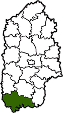
The Kamianets-Podilskyi Raion is located in the southernmost part of the Khmelnytskyi Oblast, corresponding to the modern-day boundaries of Podolia historical region. To its west and south, the raion borders upon the Ternopil and Chernivtsi Oblasts, respectfully.
It is the largest raion of the oblast, with an area of 1,537 square kilometres (593 sq mi) constituting 7.5 percent of the oblast's area.[4] A total of seven rivers flow through the raion,[4] including the Dniester and Smotrych Rivers.
History
Before the modern-day Kaimanets-Podilskyi Raion existed, a large portion of its current boundaries was under the control of other raions, one of which was the Dovzhok Raion (Ukrainian: Довжоцький район), established on March 7, 1923 as part of an administrative reorganization of the Ukrainian Soviet Socialist Republic.[5] The Dovzhok Raion was one of 16 districts of the Kamianets Okruha[5] (at the time okruhas were the first-level of administrative division of the Ukrainian SSR).
On December 4, 1928, the raion's administrative center was moved from the village of Dovzhok to Kamianets-Podilskyi, facilitating the renaming of the district to the Kamianets-Podilskyi Raion.[5] For the next few years the raion's territory kept expanding, until it was dissolved on December 26, 1934.[5] At that time, the raion was placed under the jurisdiction of the Kamianets-Podilskyi City Municipality, although de facto the raion continued to exist.[5] This decision was reversed on June 28, 1939, when the Dovzhok Raion was re-established.
On July 10, 1944, the raion's administrative center was yet again moved to Kamianets-Podilskyi.[5] Over the next 20 years, the raion's territory slowly kept expanding with the annexation of neighboring raion until January 4, 1965, when its modern-day boundaries were established.[5]
Administrative divisions
The Kamianets-Podilskyi Raion is divided in a way that follows the general administrative scheme in Ukraine. Local government is also organized along a similar scheme nationwide. Consequently, raions are subdivided into councils, which are the prime level of administrative division in the country.
Each of the raion's urban localities administer their own councils, often containing a few other villages within its jurisdiction. However, only a small amount of rural localities are organized into councils, which may also contain a few villages within its jurisdiction.
Accordingly, the Kamianets-Podilskyi Raion is divided into:[2]
- 1 settlement council—made up of the urban-type settlement of Stara Ushytsia;
- 42 village councils[6]
Overall, the raion has a total of 122 populated localities, consisting of one urban-type settlement, 120 villages, and one rural settlement.[2]
Places of interest
- Kamianets-Podilskyi Old Town,[7] the administrative center's old town neighborhood
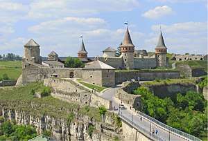
- Kamianets-Podilskyi Castle,[7] situated in the Smotrych River canyon in Kamianets-Podilskyi
- National Environmental Park "Podilski Tovtry",[8] also shared between the Horodok and Dunaivtsi Raions
- Bakota Cave Monastery,[9] located in the former village of Bakota
References
- "Leadership of the raion, schedule of the reception of citizens". Kamianets-Podilskyi Raion State Administration (in Ukrainian). Retrieved 6 February 2013.
- "Kamianets-Podilskyi Raion, Khmelnytskyi Oblast". Regions of Ukraine and their Structure (in Ukrainian). Verkhovna Rada of Ukraine. Archived from the original on 4 March 2016. Retrieved 6 February 2013.
- "Demographic situation in the raion from January-September 2012". Kamianets-Podilskyi Raion State Administration of the Khmelnytskyi Oblast (in Ukrainian). Retrieved 6 February 2013.
- "Informational reference (detailed)". Kamianets-Podilskyi Raion State Administration (in Ukrainian). Retrieved 6 February 2013.
- "History of the raion". Kamianets-Podilskyi Raion Council (in Ukrainian). Archived from the original on 27 July 2013. Retrieved 6 February 2013.
- "Selysche, town councils". Kamianets-Podilskyi Raion State Administration (in Ukrainian). Retrieved 6 February 2013.
- "Official website". National Historical-Architectural Complex "Kam'ianets" (in Ukrainian). Retrieved 6 February 2013.
- "Main". Website of the National Environmental Park "Podilskyi Tovtry". Retrieved 6 February 2013.
- "Cave monastery. 14th century. Item №1686". National Environmental Park "Podilski Tovtry" (in Russian). Retrieved 9 February 2013.
External links
| Wikimedia Commons has media related to Kamianets-Podilskyi Raion. |
- "Main Page". Kamianets-Podilskyi Raion State Administration of the Khmelnytskyi Oblast (in Ukrainian). Retrieved 6 February 2013.
- "Main Page". Kamianets-Podilskyi Raion Council (in Ukrainian). Retrieved 6 February 2013.
Administrative geographic location | ||||||||||
|---|---|---|---|---|---|---|---|---|---|---|
| ||||||||||
| Settlements | Coat of arms of Kamianets-Podilskyi Raion | |
|---|---|---|
| Raions | |||||
|---|---|---|---|---|---|
| Hromadas | |||||
| Cities |
| ||||
| |||||
| Authority control |
|
|---|