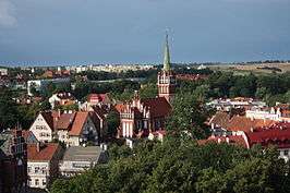
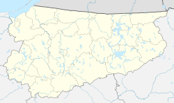
Kętrzyn
Kętrzyn (pronounced KENT-shin [ˈkɛntʂɨn] (![]()
![]()
Kętrzyn Rastembork | |
|---|---|
| |
 Flag  Coat of arms | |
 Kętrzyn 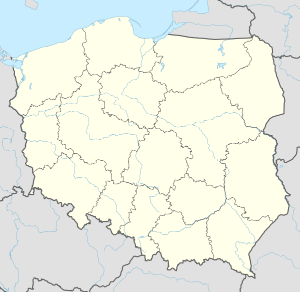 Kętrzyn | |
| Coordinates: 54°5′N 21°23′E | |
| Country | |
| Voivodeship | |
| County | Kętrzyn County |
| Gmina | Kętrzyn (urban gmina) |
| Established | 1329 |
| Town rights | 1357 |
| Government | |
| • Mayor | Krzysztof Hećman |
| Area | |
| • Total | 10.34 km2 (3.99 sq mi) |
| Population (2019) | |
| • Total | 27,478[1] |
| Time zone | UTC+1 (CET) |
| • Summer (DST) | UTC+2 (CEST) |
| Postal code | 11-400 |
| Area code(s) | +48 89 |
| Car plates | NKE |
| Website | ketrzyn.pl |
The first settlement was established in 1329 and Rastenburg was granted town rights and privileges in 1357. Over the centuries it was part of the Teutonic State, Poland and East Prussia in Germany. The town is known for the surrounding Masurian Lakeland and numerous monuments of historical value such as the Wolf's Lair in nearby Gierłoż, where an assassination attempt against Hitler was made in 1944.
History
The original inhabitants of the region were the Balt tribe of the Aesti, mentioned by Tacitus in his Germania (AD 98). The town, known in German as Rastenburg and in Polish as Rastembork, was established in 1329 in the State of the Teutonic Knights and was granted town rights in 1357 by Henning Schindekop.
In 1440, the town joined the anti-Teutonic Prussian Confederation.[3] In 1454, the town recognized Polish King Casimir IV Jagiellon as rightful ruler and the townspeople sent their representative to Königsberg to pay homage to the King.[4]
After the Thirteen Years’ War (1454–1466) the town remained part of the Teutonic Order's state and, from 1525 to 1701, the Duchy of Prussia, a Polish fief until 1657. In the second half of the 17th century, Poles constituted around a half of the town's population, the other half being Germans.[3] In 1667, a Polish church school was established.[3]
In 1701 the town became part of the Kingdom of Prussia and subsequently, in 1871, part of Germany. During the Seven Years' War, from 1758 to 1762, the town was occupied by the Russians, in June 1807, throughout the Napoleonic wars, the division of General Jan Henryk Dąbrowski was stationed in the town.
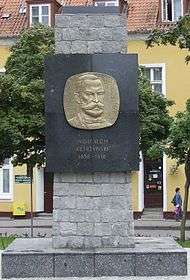
In the years 1855-1859, Wojciech Kętrzyński, a historian, activist and Polish patriot, attended the local gymnasium. In the late 19th century a Polish Lutheran parish still existed in Rastenburg,[5] despite the policy of Germanisation conducted by the Prussian authorities.[3] In the second half of the 19th century, a sugar factory, brewery and mill were built.
20th century
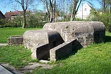
Rastenburg and the surrounding district was the scene of the First World War's First Battle of the Masurian Lakes and Second Battle of the Masurian Lakes. During the Second World War Adolf Hitler's wartime military headquarters, the Wolfsschanze (Wolf's Lair), was in the forest east of Rastenburg. The bunker was the setting for the failed assassination attempt of the 20 July plot against Hitler.
In 1945, the area suffered devastation from both the retreating Germans and advancing Soviets during the Vistula-Oder campaign. Some ruins of the Wolfsschanze remain. The town was a Wehrmacht garrison town until it was occupied by the Red Army on January 27, 1945. The largely abandoned town was heavily destroyed by the Soviets.[3]
After the war, the town was transferred to Poland under border changes promulgated at the Potsdam Conference. Its surviving German residents who had not evacuated were subsequently expelled westward and replaced with Poles, most of whom were themselves expelled from the pre-war Polish Vilnius Region that was annexed by the Soviet Union and given to the Lithuanian Soviet Socialist Republic.[3] The town was given the historic Polish name Rastembork in 1945, and in 1946 it was renamed to Kętrzyn after the Polish historian Wojciech Kętrzyński.[6][7]
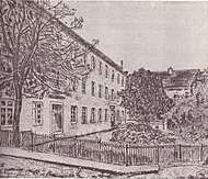
After the war, the town's life was being rebuilt. In 1945, the Municipal Theater was established.[3] Thanks to voluntary contributions, books were purchased for newly organized public libraries.[3] A museum was created in the renovated castle.[3]
Climate
Although it officially qualifies as an oceanic, defined as Cfb for Köppen classification (−3 °C isotherm), its averages are much closer to a warm-summer humid continental climate, denoted as Dfb, being better defined like that. The climate of the city has a considerable thermal amplitude, but still with some not so pronounced influence of the sea.[8][9]
| Climate data for Ketrzyn (Wilamowo Airport), elevation: 110 m or 360 ft, 1980–2012 normals and extremes | |||||||||||||
|---|---|---|---|---|---|---|---|---|---|---|---|---|---|
| Month | Jan | Feb | Mar | Apr | May | Jun | Jul | Aug | Sep | Oct | Nov | Dec | Year |
| Record high °C (°F) | 12.3 (54.1) |
14.8 (58.6) |
20.2 (68.4) |
27.5 (81.5) |
31.0 (87.8) |
32.2 (90.0) |
35.1 (95.2) |
36.1 (97.0) |
29.2 (84.6) |
23.6 (74.5) |
16.5 (61.7) |
15.0 (59.0) |
36.1 (97.0) |
| Average high °C (°F) | −0.5 (31.1) |
0.1 (32.2) |
4.8 (40.6) |
11.9 (53.4) |
17.7 (63.9) |
20.6 (69.1) |
22.5 (72.5) |
22.2 (72.0) |
17.4 (63.3) |
11.5 (52.7) |
4.8 (40.6) |
0.9 (33.6) |
11.2 (52.1) |
| Daily mean °C (°F) | −2.6 (27.3) |
−2.4 (27.7) |
1.3 (34.3) |
7.3 (45.1) |
12.7 (54.9) |
15.9 (60.6) |
17.9 (64.2) |
17.4 (63.3) |
13.0 (55.4) |
8.1 (46.6) |
2.7 (36.9) |
−1.0 (30.2) |
7.5 (45.5) |
| Average low °C (°F) | −5.2 (22.6) |
−5.3 (22.5) |
−2.3 (27.9) |
2.3 (36.1) |
6.9 (44.4) |
10.3 (50.5) |
12.5 (54.5) |
12.2 (54.0) |
8.6 (47.5) |
4.6 (40.3) |
0.4 (32.7) |
−3.4 (25.9) |
3.5 (38.2) |
| Record low °C (°F) | −32.8 (−27.0) |
−32.8 (−27.0) |
−24.0 (−11.2) |
−8.1 (17.4) |
−3.9 (25.0) |
−0.1 (31.8) |
4.8 (40.6) |
1.0 (33.8) |
−2.5 (27.5) |
−12.2 (10.0) |
−21.4 (−6.5) |
−25.0 (−13.0) |
−32.8 (−27.0) |
| Average precipitation mm (inches) | 31.7 (1.25) |
22.2 (0.87) |
31.6 (1.24) |
33.1 (1.30) |
48.0 (1.89) |
74.7 (2.94) |
73.6 (2.90) |
57.4 (2.26) |
53.7 (2.11) |
44.1 (1.74) |
43.3 (1.70) |
32.8 (1.29) |
546.2 (21.49) |
| Average precipitation days | 13.0 | 11.5 | 10.8 | 10.4 | 10.6 | 12.5 | 13.6 | 11.2 | 11.6 | 11.1 | 13.4 | 14.0 | 143.7 |
| Average snowy days | 14 | 12 | 8 | 2 | 0 | 0 | 0 | 0 | 0 | 1 | 4 | 9 | 50 |
| Mean monthly sunshine hours | 43.0 | 59.5 | 122.5 | 205.9 | 262.7 | 258.8 | 264.1 | 236.7 | 151.5 | 105.3 | 41.9 | 27.7 | 1,779.6 |
| Mean daily sunshine hours | 3 | 3 | 5 | 9 | 10 | 9 | 10 | 10 | 8 | 5 | 3 | 3 | 7 |
| Average ultraviolet index | 1 | 2 | 2 | 4 | 5 | 5 | 5 | 5 | 3 | 2 | 1 | 1 | 3 |
| Source 1: Climatebase.ru[10] | |||||||||||||
| Source 2: kiedy-jechac.pl (Snow days, daily sunshine hours and UV index[9] and Infoclimat.fr (monthly sunshine hours)[11] | |||||||||||||
People
- Johann Dietrich von Hülsen (1693–1767), Prussian general
- Karl Bogislaus Reichert (1811–1883), German anatomist, embryologist and histologist.
- Wojciech Kętrzyński (1838–1918), Polish historian and activist
- Elisabet Boehm (1859–1943), German women's rights advocate
- Arno Holz (1863–1929), German poet and dramatist
- Wilhelm Wien (1864–1928), German physicist worked on blackbody radiation
- Emma Döll (1873–1930), German politician (SPD/USPD/KPD)
- Rüdiger von Heyking (1894–1956), German Luftwaffe general
- Hanns Scharff (1907–1992), German Luftwaffe interrogator internationally renowned for developing humane, effective interrogation techniques
- Waldemar Grzimek (1918–1984), German sculptor
- Siegfried Tiefensee (1922–2009), German composer
- Dietrich von Bausznern (1928–1980), German composer, cantor, organist and music teacher
- Marek Ziółkowski (born 1955), Polish diplomat
- Krzysztof Kononowicz (born 1963), former candidate for the office of mayor of Białystok and notable internet celebrity
- Piotr Lech (born 1968), Polish footballer
- Krzysztof Raczkowski (1970–2005), former musician and drummer of the Polish death metal band Vader
Gallery
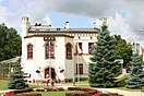
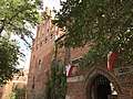 Kętrzyn Castle
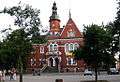 Town Hall
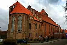
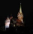 Saint Catherine of Alexandria church
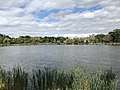 Kętrzyn Lake
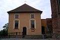 Saint John church
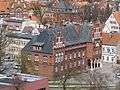 Kętrzyn County seat
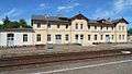 Train station
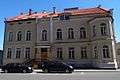 Tax office
.jpg) Old townhouses in the town center
Old townhouses in the town center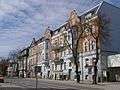 Old townhouses in the town center
.jpg) Former bank building
Former bank building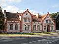 Old house
International relations
Twin towns – Sister cities
Kętrzyn is twinned with:


References
- http://www.polskawliczbach.pl/Ketrzyn
- "Rastembork, Poland – Geographical Names, map, geographic coordinates". geographic.org. Retrieved June 21, 2019.
- "Archived copy". Archived from the original on April 21, 2018. Retrieved February 21, 2020.CS1 maint: archived copy as title (link) CS1 maint: BOT: original-url status unknown (link) dr Jerzy Sikorski, Historia miasta Kętrzyn
- Tomasz Darmochwał, Marek Jacek Rumiński, Warmia Mazury. Przewodnik, Agencja TD, Białystok, 1996, p. 123 (in Polish)
- Słownik geograficzny Królestwa Polskiego i innych krajów słowiańskich, Tom IX, Warsaw, 1888, p. 531 (in Polish)
- "Urząd Miasta Kętrzyn – Zainwestuj w Kętrzynie". Retrieved June 21, 2019.
- Maria Malec (2002). Słownik etymologiczny nazw geograficznych Polski. Wydawn. Naukowe PWN. p. 122. Retrieved May 4, 2012.
- "Ketrzyn, Poland Köppen Climate Classification (Weatherbase)". Weatherbase. Retrieved August 5, 2019.
- "Klimacie Kętrzyn – Temperatura • Kiedy jechać • Pogoda". Kiedy-jechac.pl (in Polish). Retrieved August 5, 2019.
- "Ketrzyn, Poland #12185". Climatebase.ru. Retrieved August 5, 2019.
- "Normales et records climatologiques 1981–2010 à Ketrzyn – Infoclimat". infoclimat.fr. Retrieved August 5, 2019.
External links
| Wikimedia Commons has media related to Kętrzyn. |
| Wikisource has the text of the 1905 New International Encyclopedia article Rastenburg. |
Seat: Kętrzyn (urban gmina) | ||
| Urban-rural gminas |  | |
| Rural gminas | ||
| Authority control |
|
|---|