Jonesville, Louisiana
Jonesville is the largest town in Catahoula Parish, Louisiana, United States, at the confluence of the Ouachita, Tensas, and Little rivers. The three rivers become the Black River at Jonesville.
Jonesville, Louisiana Troyville | |
|---|---|
Town | |
 Motorists used the old Black River bridge in Jonesville prior to completion of the new structure to the right. | |
| Nickname(s): Bucktown | |
 Location of Jonesville in Catahoula Parish, Louisiana. | |
.svg.png) Location of Louisiana in the United States | |
| Coordinates: 31°37′30″N 91°49′35″W | |
| Country | United States |
| State | Louisiana |
| Parish | Catahoula |
| Government | |
| • Mayor | Milton Ceasar (D)[1] |
| Area | |
| • Total | 1.92 sq mi (4.97 km2) |
| • Land | 1.92 sq mi (4.97 km2) |
| • Water | 0.00 sq mi (0.00 km2) |
| Elevation | 59 ft (18 m) |
| Population (2010) | |
| • Total | 2,265 |
| • Estimate (2019)[3] | 2,000 |
| • Density | 1,041.67/sq mi (402.26/km2) |
| Time zone | UTC-6 (CST) |
| • Summer (DST) | UTC-5 (CDT) |
| Area code(s) | 318 |
| FIPS code | 22-38775 |
The Jonesville population was 2,265 at the 2010 census.[4] The parish seat is Harrisonburg to the north, which is even smaller than Jonesville.
The four rivers which intersect near Jonesville are all subject to flooding. There are surrounding soybean and cotton fields. A few plantation houses still stand, reminiscent of the former slavery-based, planter-dominated economy. The population fell significantly when a textile mill shut down in the late 1980s.[5]
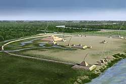
Troyville Earthworks
Jonesville was once the site of the Troyville Earthworks; built by ancient Native Americans who occupied the site from 100 BCE to 700 CE. Once home to between 9-11 mounds, most have been leveled to make way for the construction of the modern town; including the Great Mound which was once 82 feet (25 m) in height. It was the tallest mound in Louisiana and the second tallest in the United States after Monks Mound at Cahokia in Illinois. It was destroyed for bridge approach fill in 1931. The site is the type site for the Troyville culture of the lower Ouachita and Tensas River valleys.[6][7]
Skylar Dore case
Skylar M. Dore (born January 1985),[8] the white Republican former police chief of Jonesville, was dismissed in 2016 after he posted profane and inflammatory comments on Facebook regarding the shooting of three white police officers by a lone black gunman in Louisiana's capital city, Baton Rouge. The massacre occurred ten days after five officers were killed in Dallas, Texas. Many black residents, who make up more than two-thirds of the Jonesville population, saw Dore's message as "racist", and the majority-black town council soon removed him as chief. Reports also surfaced of unsubstantiated allegations that Dore, who was reared in New Iberia, Louisiana, had caused the death of a black man in custody while Dore was working in 2012 as a police officer in Baldwin in St. Mary Parish.[5]
Hiram Evans, the first black mayor of Jonesville, said that the Dore case left him "bewildered and surprised", but that he did not know if Dore is actually a racist: "That's a situation between him and God."[5]
Dore meanwhile operates FleX Fitness, the only gymnasium in Jonesville.[5]
Geography
Jonesville is located at 31°37′30″N 91°49′35″W (31.624934, −91.826339).[9] Its northern border is formed by the Little River, while its eastern border is formed by the Black River. The confluence of the Ouachita and Tensas rivers to form the Black River is 0.4 miles (0.64 km) north of the town limits. Concordia Parish is to the east across the Black River.
U.S. Route 84 passes through the town as 4th Street and leads east 16 miles (26 km) to Ferriday and west 23 miles (37 km) to Jena. Louisiana State Highway 124 leads north 10 miles (16 km) to Harrisonburg, the Catahoula Parish seat, and south 24 miles (39 km) to its end in Argo.
According to the United States Census Bureau, Jonesville has a total area of 1.9 square miles (5.0 km2), all land.[4]
Demographics
| Historical population | |||
|---|---|---|---|
| Census | Pop. | %± | |
| 1880 | 90 | — | |
| 1890 | 172 | 91.1% | |
| 1910 | 287 | — | |
| 1920 | 1,029 | 258.5% | |
| 1930 | 1,123 | 9.1% | |
| 1940 | 2,080 | 85.2% | |
| 1950 | 1,954 | −6.1% | |
| 1960 | 2,347 | 20.1% | |
| 1970 | 2,761 | 17.6% | |
| 1980 | 2,828 | 2.4% | |
| 1990 | 2,720 | −3.8% | |
| 2000 | 2,469 | −9.2% | |
| 2010 | 2,265 | −8.3% | |
| Est. 2019 | 2,000 | [3] | −11.7% |
| U.S. Decennial Census[10] | |||
As of the census[11] of 2000, there were 2,469 people, 916 households, and 620 families residing in the town. The population density was 1,291.4 people per square mile (499.1/km2). There were 1,032 housing units at an average density of 539.8 per square mile (208.6/km2). The racial makeup of the town was 39.77% White, 59.17% African American, 0.28% Native American, 0.12% Asian, and 0.65% from two or more races. Hispanic or Latino of any race were 0.97% of the population.
There were 916 households, out of which 36.0% had children under the age of 18 living with them, 34.7% were married couples living together, 28.2% had a female householder with no husband present, and 32.3% were non-families. 28.7% of all households were made up of individuals, and 11.6% had someone living alone who was 65 years of age or older. The average household size was 2.57 and the average family size was 3.15.
In the town, the population was spread out, with 29.5% under the age of 18, 9.3% from 18 to 24, 26.2% from 25 to 44, 18.7% from 45 to 64, and 16.3% who were 65 years of age or older. The median age was 35 years. For every 100 females, there were 84.7 males. For every 100 females age 18 and over, there were 74.5 males.
The median income for a household in the town was $18,622, and the median income for a family was $23,462. Males had a median income of $21,139 versus $18,482 for females. The per capita income for the town was $10,173. About 31.1% of families and 36.8% of the population were below the poverty line, including 49.7% of those under age 18 and 25.5% of those age 65 or over.
Jonesville gallery

Catahoula Bank in downtown Jonesville 
Riverside Park in Jonesville at formation of Black River 
Catahoula News Booster office in Jonesville, a weekly newspaper which was owned by the late Sam Hanna from 1974 to 1988 
First Baptist Church of Jonesville observed its centennial in September 2008. The church has a recreation center across from the sanctuary. 
Climate
The climate in the area is characterized by hot, humid summers and generally mild-to-cool winters. According to the Köppen Climate Classification system, Jonesville has a humid subtropical climate, abbreviated "Cfa" on climate maps.[12]
Notable people
- William B. Atkins, former member of both houses of the Louisiana legislature; Jonesville resident
- Charles A. Marvin, district attorney of Bossier and Webster parishes (1971-1975) and judge of the Louisiana Circuit Court of Appeal for the Second District in Shreveport (1975-1999), born in Jonesville in 1929[13]
- Chris Shivers, champion rodeo performer, resides with his family in Jonesville
References
- "Election Returns: Catahoula Parish". Louisiana Secretary of State. November 6, 2018. Archived from the original on May 18, 2019. Retrieved November 9, 2018.
- "2019 U.S. Gazetteer Files". United States Census Bureau. Retrieved July 25, 2020.
- "Population and Housing Unit Estimates". United States Census Bureau. May 24, 2020. Retrieved May 27, 2020.
- "Geographic Identifiers: 2010 Demographic Profile Data (G001): Jonesville town, Louisiana". U.S. Census Bureau, American Factfinder. Archived from the original on February 12, 2020. Retrieved August 18, 2014.
- Michael E. Miller (September 17, 2016). "A white police chief rants on Facebook, and a Louisiana town hears echoes of its racist past". The Washington Post. Archived from the original on February 22, 2017. Retrieved February 20, 2017.
- "Indian Mounds of Northeast Louisiana: Troyville Earthworks". Louisiana Dept. Of Culture, Recreation & Tourism. Archived from the original on May 3, 2017. Retrieved December 22, 2017.
- "Final excavation of Troyville Mounds underway". Catahoula Parish History. April 18, 2005. Archived from the original on April 25, 2012. Retrieved October 22, 2011.
- "Skylar Dore, January 1985". Louisiana Secretary of State. Retrieved February 21, 2017.
- "US Gazetteer files: 2010, 2000, and 1990". United States Census Bureau. February 12, 2011. Retrieved April 23, 2011.
- "Census of Population and Housing". Census.gov. Retrieved June 4, 2015.
- "U.S. Census website". United States Census Bureau. Retrieved January 31, 2008.
- "Climate Summary for Jonesville, Louisiana". Archived from the original on October 3, 2015. Retrieved November 18, 2013.
- "Charles Marvin". genealogybuff.com. Archived from the original on September 21, 2013. Retrieved November 28, 2013.
External links
- Jonesville Progress Community Progress Site for Jonesville, LA
- DiscoverCatahoula.com Community Website for Catahoula Parish, LA
| Wikimedia Commons has media related to Jonesville, Louisiana. |
Municipalities and communities of Catahoula Parish, Louisiana, United States | ||
|---|---|---|
Parish seat: Harrisonburg | ||
| Town | 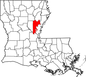 | |
| Villages | ||
| CDP | ||
| Other unincorporated communities | ||
| Footnotes | ‡This populated place also has portions in an adjacent parish or parishes | |
| Authority control |
|
|---|