Inverloch, Victoria
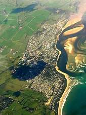
Inverloch /ˈɪnvərlɒk/ is a seaside town located in Victoria, Australia. It is located 143 kilometres (89 mi) south east of Melbourne via the South Gippsland Highway on the Bass Highway at the mouth of Anderson Inlet, in the Bass Coast Shire of Gippsland, Victoria, Australia. Known originally for the calm waters of Anderson Inlet, it is now also known for the discovery of Australia's first dinosaur bone and at the 2016 census it had a population of 5,437.[1]
| Inverloch Victoria | |||||||||
|---|---|---|---|---|---|---|---|---|---|
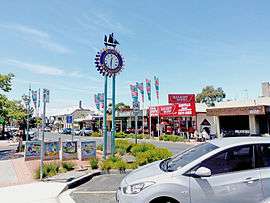 Shopping Strip, Abeckett Street | |||||||||
 Inverloch | |||||||||
| Coordinates | 38.6334°S 145.7278°E | ||||||||
| Population | 5,437 (2016 census)[1] | ||||||||
| Postcode(s) | 3996 | ||||||||
| Elevation | 20.7 m (68 ft) | ||||||||
| Location |
| ||||||||
| LGA(s) | Bass Coast Shire | ||||||||
| State electorate(s) | Bass | ||||||||
| Federal Division(s) | Monash | ||||||||
| |||||||||
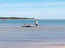
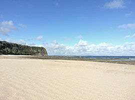
Inverloch is a popular tourist destination, particularly for swimming, kitesurfing and windsurfing at the calm waters of Anderson Inlet. Fishing and surfing are also popular.
The town was first named Anderson Inlet after Samuel Anderson,after who the inlet was named following his discovery and report . It was later renamed Inverloch after Loch Inver (Lake Entrance) in Scotland.
Today
Anderson Inlet
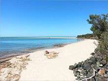
Anderson Inlet is a shallow and dynamic estuary where the Tarwin River enters Bass Strait. It forms a 2,400 ha almost enclosed bay next to Inverloch, for which it provides a popular and protected beach. At low tide its intertidal mudflats provide important feeding habitat for migratory waders. It is named after the Anderson brothers, the first Europeans to settle in the area.[2][3] Anderson Inlet is classified by BirdLife International as an Important Bird Area. It supports internationally significant numbers (up to over 6,000 individuals) of red-necked stint. It has also been known to support the critically endangered orange-bellied parrot, with six birds seen there in 1998 and two in 1999.[4] Seashell collecting is permitted from The Caves (beach) to north-east past the main shopping precinct. Seashell collecting is prohibited in the Bunurong Marine National Park, namely The Oaks, Twin Reefs, Shack Bay and Eagles Nest (beaches) heading south-west after Flat Rocks and The Caves.[5]
Farmers Market
The town showcases local produce from the farms and towns of South Gippsland, local artists, entertainers, community groups and service clubs at a monthly market held by the Lions Club on the LAST Sunday of every month.
Shell Museum
Inverloch has a Shell Museum which also has a dinosaur exhibition.[6][7] It is located opposite the Rainbow Park. Australia’s first dinosaur bone, and many other dinosaur bones, were discovered in Inverloch.[8]
Coast
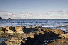
Inverloch beaches include Twin Reefs, Shack Bay, Eagles Nest, The Caves, Flat Rocks, Main Surf Beach, two more surf beaches, Anderson Inlet-Western Beach, Anderson Inlet-Browns Beach, Anderson Inlet-Venus Street and Anderson Inlet-The Glades.[9] Twin Reefs, Shack Bay and Eagles Nest make up most of the Bunurong Marine National Park (excluding The Oaks in Cape Paterson). The Caves and Flat Rocks are a part of the Bunurong Marine Park, which starts at Coal Point in Harmers Haven.
RACV
During 2005 and early 2006 the Royal Automobile Club of Victoria built an eco-village holiday resort on the Cape Paterson Road in Inverloch.
Bunurong Marine Parks
Bunurong Marine Park is a 17 km marine and coastal park along the coast of Harmers Haven, Cape Paterson and Inverloch namely Coal Point to Wreck Creek.
Bunurong Marine NATIONAL Park is an outstretching middle section of Bunurong Marine Park. The National Park part is about 21 km2 or about 5 km in length along the coast and stretching from 2.5 km east of Cape Paterson eastwards to a point 6 km south-west of Inverloch, extending seawards for 3 nm to the limit of Victorian waters. The restricted zone/state park (Bunurong Marine National Park inside Bunurong Marine Park), on foot begins after Undertow Bay heading towards Inverloch from Cape Paterson. It is an area past Safety Beach and rockpool and past Undertow Bay beach namely The Oaks, Twin Reefs, Shack Bay and Eagles Nest. It ends at Wreck Creek in Inverloch.[10] It is prohibited to kill or take any matter (i.e., catch fish, collect seashells or kill or take any sea or land creature, living or dead) from the smaller of the two parks; Bunurong Marine National Park.[5]
Both parks are named after the Bunurong Aboriginal people.
Bunurong Marine Park is considered special due to the unusual set of environmental conditions. It supports many marine animals including seastars, featherstars, crabs, snails, 87 species of fish, Whales and Seals. It has the highest recorded diversity of intertidal and subtidal invertebrates in eastern Victoria. The range of seaweed species is large.[11]
Flat Rocks is a beach which has large rockpools for rockpooling/rambling and direct access from Cape Paterson-Inverloch Road. Bunurong Marine Park is seen and accessed at many different points along this coast, a popular one being near Cape Paterson caravan park on Surf Beach Road as it has a modified rockpool for swimming.[12] The National Park is around to the left. Direct and more difficult access to the National Park is via car parks off Cape Paterson-Inverloch Road. Exploring, snorkelling[13] and scuba diving are popular. There are boat launching facilities at Inverloch on Anderson Inlet.[14]
Eagles Nest
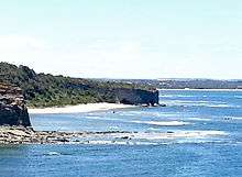
Eagles Nest is a large rock structure adjacent to the coastline that resembles the top half of a map of Australia.[15]
The Caves
The Caves is a beach with a set of pirate caves just past Eagles Nest.
Fishing
Inverloch is very popular for surf and bay fishing. Anderson Inlet and Inverloch Surf Beach are popular for fishing and a good catch is usually found. Surf fishing usually produces fish such as Silver Trevally, King George Whiting, Flathead, Mullet and Juvenile Snapper (pinky). There are two boat launches on in Inverloch on Anderson Inlet.[16]
Festivals
The town hosts a jazz festival each Labour Day long weekend in March, featuring high-profile local and interstate musicians. The Food And Wine Festival is also in March.
Climate
Inverloch's location on the north shore of Bass Strait gives it an oceanic climate, with the moderating effect of the ocean allowing a narrower temperature range throughout the year compared to other regions in Victoria. Average daily maximum temperatures range from 23.5 °C in summer to 13.5 in winter. Frost is rare, occurring on average 6 mornings a year. On 10 August 2005 Inverloch received its first snowfall since July 1951, with snow even settling briefly on the beach.[17]
History
The Bunurong aboriginal people were custodians of this stretch of coast for thousands of years prior to white settlement. The Boakoolawal clan lived in the Kilcunda area south of the Bass River, and the Yowenjerre were west of the Tarwin River along what is now the Bunurong Marine and Coastal Park. Middens containing charcoal and shellfish mark the location of their campsites along the coast.[16]
The first European to settle in the Inverloch area was Samuel Anderson, who, together with his brothers and Robert Massie, ran cattle and grew wheat in the area. The Post Office opened on 1 September 1883 as Anderson's Inlet and was renamed Inverloch in 1889.[18] The inlet on which the town is situated on is named Anderson Inlet after Samuel Anderson.
As the area developed Inverloch became a port for the shipment of black coal from Wonthaggi to Melbourne.
Australia’s first dinosaur bone, the Cape Paterson Claw, was discovered here in 1903 by William Ferguson in Cape Paterson or what is now Eagles Nest, Bunurong Marine National Park, Inverloch. Today, the Dinosaur Dreaming fossil excavation at the Flat Rocks coastal site by Anderson Inlet attracts both Australian and international visitors.[8] More than 6000 bones and teeth of small dinosaurs, mammals, birds, turtles and fish have been excavated.[14]
Population
In the 2016 Census, there were 5,437 people in Inverloch. 79.6% of people were born in Australia. The next most common country of birth was England at 4.6%. 89.1% of people spoke only English at home. The most common responses for religion were No Religion 39.5%, Catholic 20.0% and Anglican 14.9%.[1]
Education
Inverloch has one primary school. Nearby Wonthaggi has one secondary college and Leongatha also has secondary schools. Also in Wonthaggi Chisholm TAFE,[19] Bass Coast Specialist School,[20] Bass Coast Adult Education Centre,[21] University of the Third Age (U3A) retirees education centre,[22] and Connecting Skills Australia (CSA) specialist developmental school, support and employment services/training.[23] Plans are underway for a new tertiary education facility.[24]
Facilities
- Farmers' market - 3rd Sunday every month, The Glade, Esplanade[16]
- Anderson Inlet
- Surf Lifesaving Club, Geroke Street
- Shell Museum and Dinosaur Exhibition, Ramsey Boulevard[6]
- Seashell Collecting is permitted on Inverloch coast from The Caves to Anderson Inlet - Small sizes and small quantities of empty seashells, driftwood, dead fallen twigs's, sea glass and interesting rubbish[5]
- Wyeth-McNamara Park - playground, shaded picnic areas, tables, barbecues, Ramsey Boulevard[16]
- Melaleuca Links Golf Course, Bass Highway - 9 hole, par 3[25]
- Inverloch Tennis Club, Pier Road[26]
- Bunurong Marine Park - explore/snorkel, directly off Cape Paterson-Inverloch Road[27]
- Bunurong Marine National Park - protected state park, explore/snorkel, Steps off Cape Paterson-Inverloch Road[27]
- Screw Creek Walk (and Mangroves), eastern end of the Esplanade:[28]
- Inverloch has large chain stores; RACV Inverloch Resort (accommodation choices & restaurant/Sunday buffet), Foodworks supermarket. Four real estate agencies; Stockdale & Leggo, LJ Hooker, Alex Scott and First National. Mitre 10 (hardware), farmers market 3rd Sunday every month, cafes, restaurants, pubs, motels, bed and breakfasts, three caravan parks and a foreshore camping reserve.[29]
- Wonthaggi Museum - open Saturday mornings, Murray Street, Wonthaggi[30]
- State Coal Mine - museum and tours, Garden Street, Wonthaggi[31]
- Wonthaggi Hospital - Graham Street, Wonthaggi[32]
References
- "2016 Census Quickstats Inverloch". Australian Bureau of Statistics. Retrieved 5 April 2019.
- About Inverloch Archived 24 December 2008 at the Wayback Machine
- Anderson Inlet Boating Area Archived 19 May 2009 at the Wayback Machine
- "IBA: Anderson Inlet". Birdata. Birds Australia. Archived from the original on 6 July 2011. Retrieved 19 May 2011.
- Department of Environment And Primary Industries, retrieved 13 November 2013
- Inverloch Shell Museum, retrieved 28 October 2013
- Dinosaur Museum, retrieved 14 November 2013
- The Museum of Victoria, retrieved 14 November 2013
- Bass Coast Information Centres, retrieved 18 November 2013
- Bunurong Marine National Park, Parks Victoria, 2010, retrieved 13 November 2013
- Please Take Me To, archived from the original on 8 February 2014, retrieved 14 November 2013
- CPCP, retrieved 14 November 2013
- South Gippsland, retrieved 13 November 2013
- Parks Victoria, retrieved 14 November 2013
- Film Gippsland, archived from the original on 7 October 2013, retrieved 14 November 2013
- Department of Environment And Primary Industries, retrieved 3 November 2013
- "Australian Weather News". Retrieved 11 February 2010.
- Premier Postal History, Post Office List, retrieved 11 April 2008
- Chisholm TAFE, retrieved 28 October 2013
- Bass Coast Specialist School, retrieved 28 October 2013
- Bass Coast Adult Education Centre, retrieved 28 October 2013
- University of the Third Age (U3A), retrieved 28 October 2013
- Connecting Skills Australia, archived from the original on 10 November 2013, retrieved 6 November 2013
- Bass Coast Shire, archived from the original on 9 November 2013, retrieved 11 November 2013
- Melaleuca Golf Course, retrieved 11 December 2013
- "McNamara Tennis Coaching".
- Parks Victoria, retrieved 13 November 2013
- The Sydney Morning Herlad, retrieved 17 December 2013
- Street Advisor, retrieved 28 October 2013
- Wonthaggi Historical Society, retrieved 11 November 2013
- Parks Victoria, retrieved 27 October 2013
- Bass Coast Regional Health, archived from the original on 28 September 2013, retrieved 30 October 2013
- Australian Postcodes, retrieved 19 November 2013
- Google Maps, retrieved 19 November 2013
External links
- Dinosaur Dreaming Web Site
- Dinosaur Dreaming At Inverloch
- Inverloch Holiday Online Directory
- Inverloch Surf Lifesaving Club Website
- Inverloch Windsurfing Club Website
- Inverloch Historical Society