Interstate 295 (North Carolina)
Interstate 295 and North Carolina Highway 295 (I-295 / NC 295), also known as the Fayetteville Outer Loop, is a partially completed Interstate-grade planned 34-mile (55 km) bypass around the western side of Fayetteville, North Carolina.
| ||||
|---|---|---|---|---|
| Fayetteville Outer Loop | ||||
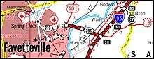
%26groups%3D_c994570e80e96111fe5d9486e7d641f32754594a.svg)
Completed section highlighted in red, future section highlighted in dark blue | ||||
| Route information | ||||
| Length | 19.3 mi[1] (31.1 km) | |||
| Existed | 2011–present | |||
| Major junctions | ||||
| South end | Cliffdale Road in Fayetteville | |||
| ||||
| North end | ||||
| Location | ||||
| Counties | Cumberland | |||
| Highway system | ||||
| ||||


Route description
I-295 begins at Cliffdale Road, running north to the All-American Freeway, then running east to Bragg Boulevard, where it is then part of a 1.5-mile (2.4 km) concurrency with NC 24 and NC 87 until Murchison Road. Heading further east, it connects with US 401 at Ramsey Street before crossing the Cape Fear River and connecting with River Road before ending at its northern terminus at Interstate 95/US 13, near Eastover. The entire 14.1-mile (22.7 km) route is a divided four-lane highway with a maximum speed limit of 65 miles per hour (105 km/h). Exit numbers along the route match NC 295 mile markers added in 2014 when previous signage designating the route Future Interstate 295 were removed and replaced with NC 295 signs, both along the Loop itself and at the Loop's interchange with I-95.[2]
Dedicated and memorial names
I-295 has two dedicated stretches of freeway.
- The Airborne and Special Operations Highway – Official North Carolina name of I-295 from I-95 to Raeford Road. Approved July, 2014 and dedicated on August 16, 2014 at the Airborne & Special Operations Museum.[3]
- Lyndo Tippett Highway - Official North Carolina name of I-295 from I-95 to Ramsey Street. Approved May 2019 and dedicated on October 10 2019.[4]
History
The future designation of the Fayetteville Outer Loop as Interstate 295 was approved by the American Association of State Highway and Transportation Officials (AASHTO) in May 2005 following an earlier approval by the Federal Highway Administration (FHWA). Signs designation "Future I-295" were put up along the route when the section between Interstate 95 and River Road was opened in July 2005. The first short section of this highway had opened earlier in June 2003, and it extended only from River Road to US 401. Then, the only mentions of a highway number were on street signs at the entrance ramps that said I-295 (with an additional "FUTURE" on some). In May 2019 the FHWA officially added the currently open 14.1 miles of NC 295 to the Interstate System, this follows up on approval by AASHTO in the fall of 2018.[5] For the foreseeable future though the highway will still be marked as NC 295. NCDOT may have received a waiver since two parts of it (namely the bridge that crosses the Cape Fear River and its interchange with I-95) are not quite up to Interstate Highway standards.[6]
Construction on the next section of Interstate 295, located from US 401 to the "All-American Freeway", was scheduled to start in the later months of 2008, and then probably completed by early 2012, but this construction project was put on hold in November 2008 due to the severe shortage of money for highway construction in North Carolina at that time and extending though 2011.[7] Instead of constructing this segment as one contract, work was split up into 3 smaller segments. Work first started in 2009 on the section from Bragg Boulevard (North Carolina Highway 24, NC 24) to Murchison Road (NC 210) using federal stimulus monies. This was completed in 2014. In March 2011 a contract to construct the portion of the Loop between US 401 and Murchison Road was awarded to a construction company, however this did not include final paving. The contract for paving was issued in 2014 and is scheduled to be completed during the summer of 2016, delayed from April 2014.[8]
On August 4, 2014, a 1.7-mile (2.7 km) new section of the Fayetteville Outer Loop opened between Murchison Road and Bragg Boulevard. Considered critical in relieving congestion around Fort Bragg, this section traverses eastbound along collector-distributor lanes between the two exits, while westbound uses an actual stretch of the freeway. Signage along this stretch reflected a rerouting of NC 24/NC 87. On August 11, 2016, a 6.5-mile (10.5 km) new section opened between Murchison Road and Ramsey Street, connecting the two existing segments of the Fayetteville Outer Loop together.[9][10] Another segment continuing the Loop to All-American Freeway was opened on December 2, 2016.[3][11][12] On November 25, 2019, a nearly 7-mile (11 km) segment opened between the All American Freeway and Cliffdale Road.[13]
The remainder of the route south to Interstate 95 near St. Paul's is to be completed in segments, with construction starting between 2018 and 2020 with the Loop not scheduled to be totally complete until around 2025.[2] NC Governor McCrory announced in December 2015 that the remaining segments would now be funded under changes to the state's method of apportioning transportation funds. These changes were approved by the NCDOT Board in January 2016.[14]
Route number changes
| |
|---|---|
| Location | Fayetteville–Eastover, NC |
| Length | 16.4 mi[9] (26.4 km) |
| Existed | 2011–2019 |
The Fayetteville Outer Loop has had a variety of actual and proposed highway designations over the years. Its first proposed Interstate designation, rejected by AASHTO in 2003, was Interstate 195. Other earlier designations have included extensions of US 13 (in some newspaper articles) or as NC 24. It was signed as Future Interstate 295 from 2005 to 2014, which also appeared on state maps from 2006 to 2012.
On July 23, 2011, NCDOT officially designated the Fayetteville Outer Loop as North Carolina Highway 295. The circumstances for the rule change cited was necessary for public safety and welfare. This marks its official establishment, six years after the first section of the new freeway was completed.[15][16] On January 15, 2019, the FHWA approved the I-295 designation between All American Freeway and I-95/US 13 after NCDOT completed two design changes that were acceptable. Effective that same day, NC 295 was decommission in favor of I-295.[17]
| |
|---|---|
| Location | Fayetteville, North Carolina |
| Length | 5.7 mi[18] (9.2 km) |
| Existed | 2020–present |
On April 21, 2020, North Carolina Highway 295 was reestablished in an encore designation between Cliffdale Road (SR 1400) and All American Expressway (SR 1007). The reason for its reintroduction is interstate designations must end at a National Highway System route. Once the route connecting US 401 is completed a request for interstate designation will be submitted.[18]
Exit list
| County | Location | mi[1] | km | Exit | Destinations | Notes |
|---|---|---|---|---|---|---|
| Robeson | | Proposed interchanges (Under Construction)[14][19] | ||||
| | Leeper Road | |||||
| Cumberland | | Camden Road | ||||
| | Strickland Bridge Road | |||||
| Fayetteville | Proposed interchange (Under Construction)[14] [19] | |||||
| 14.8 | 23.8 | 15 | Cliffdale Road | Northbound entrance and southbound exit | ||
| 18.2 | 29.3 | 18 | Canopy Lane | |||
| 20.3 | 32.7 | 21A-B | All American Freeway | signed as NC 295 south of this exit, and I-295 north of this exit | ||
| 20.8 | 33.5 | 21C | East end of NC 24 and south end of NC 87 overlap | |||
| 22.3 | 35.9 | 23 | West end of NC 24 and north end of NC 87 overlap To Fayetteville State University and Simmons AAF | |||
| 24.9 | 40.1 | 25A-B | McArthur Road | |||
| 27.6 | 44.4 | 28 | To Methodist University | |||
| | 30.2 | 48.6 | 30 | River Road | ||
| Eastover | 34.0 | 54.7 | 34 | Exit 58 of I-95 | ||
| — | Continuation as US 13 | |||||
1.000 mi = 1.609 km; 1.000 km = 0.621 mi
| ||||||
References
- Google (December 7, 2019). "Interstate 295 (North Carolina)" (Map). Google Maps. Google. Retrieved December 7, 2019.
- "I-295 Fayetteville Outer Loop". Retrieved July 27, 2019.
- "NCDOT to Open New Stretch of Fayetteville Outer Loop from Murchison Road to Bragg Boulevard on Monday" (Press release). Raleigh, NC: North Carolina Department of Transportation. August 1, 2014. Retrieved August 27, 2014.
- "NCDOT Dedicates Lyndo Tippett Highway in Fayetteville" (Press release). Raleigh, NC: North Carolina Department of Transportation. October 10, 2019. Retrieved May 15, 2020.
- |url=https://www.fhwa.dot.gov/planning/national_highway_system/interstate_highway_system/routefinder/table02.cfm |title=FHWA Interstate Route Log and Finder List, Table 2-Auxiliary Routes |date=May 6, 2019 |accessdate=July 27, 2019
- Fayetteville Outer Loop Trip, Adam Prince February 26, 2005
- "Fayetteville Defends Funding for I-295". Raleigh, NC: WRAL-TV. January 6, 2009. Retrieved October 5, 2014.
- "Contract awarded for next phase of Fayetteville Outer Loop". The Fayetteville Observer. March 10, 2011. Retrieved August 20, 2016.
- DeVane, Steve (August 11, 2016). "I-95 to Bragg Blvd. section of Outer Loop open to traffic". The Fayetteville Observer. Retrieved August 20, 2016.
- "Fayetteville loop now links Bragg, I-95". Raleigh, NC: WRAL-TV. August 11, 2016. Retrieved August 11, 2016.
- Futch, Michael (August 4, 2014). "Fayetteville's Outer Loop segment opens, connects Bragg Boulevard and Murchison Road". The Fayetteville Observer. Retrieved August 27, 2014.
- Barksdale, Andrew (December 1, 2016). "Ramsey Street to Cross Creek Mall without a Single Stoplight? Yes, Really". The Fayetteville Observer. Retrieved December 2, 2016.
- Baez, Gilbert (November 25, 2019). "Ribbon cutting marks Fayetteville Outer Loop official opening". Capitol Broadcasting Company, Inc. WRAL-TV. Retrieved November 27, 2019.
- Bob Malme. "Future I-295 - Fayetteville Outer Loop". Retrieved July 27, 2019.
- "NC 295 Route Change (2011-07-12)" (PDF). North Carolina Department of Transportation. July 12, 2011. Retrieved February 23, 2013.
- "Route Change (2015-05-12)" (PDF). North Carolina Department of Transportation. May 12, 2015. Retrieved February 15, 2016.
- "Route Change (2019-01-15)" (PDF). North Carolina Department of Transportation. January 15, 2019. Retrieved December 5, 2019.
- "Route Change (2020-04-21)" (PDF). North Carolina Department of Transportation. April 21, 2020. Retrieved May 15, 2020.
- "STIP Division 6" (PDF). Archived from the original (PDF) on December 17, 2010. Retrieved January 25, 2011.
External links

- I-295 on Kurumi.com
- Fayetteville Outer Loop
- NCRoads.com: I-295
- NCRoads.com: N.C. 295
| ||