Hollister, North Carolina
Hollister is a census-designated place and unincorporated community in Halifax County in northeastern North Carolina, United States. As of the 2010 census it had a population of 674.[3] Hollister's ZIP code is 27844.
Hollister, North Carolina | |
|---|---|
 Hollister  Hollister | |
| Coordinates: 36°15′22″N 77°56′09″W | |
| Country | United States |
| State | North Carolina |
| County | Halifax |
| Elevation | 246 ft (75 m) |
| Population (2010) | |
| • Total | 674 |
| • Density | 169/sq mi (65.4/km2) |
| Time zone | UTC-5 (Eastern (EST)) |
| • Summer (DST) | UTC-4 (EDT) |
| ZIP code | 27844 |
| Area code(s) | 252 |
| FIPS code | 37-32100 |
| GNIS feature ID | 1020803[1] |
| [2] | |
History
Matthews Place and White Rock Plantation are listed on the National Register of Historic Places.[4]
Geography
Hollister is located in southwestern Halifax County at 36°15′22″N 77°56′09″W (36.255984, -77.935818),[1] in the Roanoke Rapids micropolitan area. Its elevation is 246 feet (75 m). North Carolina Highway 561 passes through the community, leading east 13 miles (21 km) to Interstate 95 and southwest 24 miles (39 km) to Louisburg.
Schools
Hollister operates under Halifax County schools. Hollister Elementary School and Haliwa-Saponi Tribal School are in the community. Hollister Elementary is a public school that enrolls students in grades K-5, and Haliwa-Saponi Tribal is a charter school that enrolls students in grades K-12.[5]
References
- U.S. Geological Survey Geographic Names Information System: Hollister, North Carolina. Retrieved on 2008-06-20.
- "ZIP Code Lookup". Retrieved 2008-06-20.
- "Geographic Identifiers: 2010 Census Summary File 1 (G001): Hollister CDP, North Carolina". American Factfinder. U.S. Census Bureau. Archived from the original on February 13, 2020. Retrieved December 7, 2017.
- "National Register Information System". National Register of Historic Places. National Park Service. July 9, 2010.
- Schools in Halifax County, North Carolina/NC, Schooltree.org, Retrieved on 2008-06-20.
External links
- Hollister, North Carolina at ePodunk.
Municipalities and communities of Halifax County, North Carolina, United States | ||
|---|---|---|
| City | 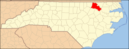 Halifax County map | |
| Towns | ||
| CDPs | ||
| Unincorporated communities | ||