Harbert Landing, Mississippi
Harbert Landing is a ghost town in Tunica County, Mississippi, United States.
Harbert Landing, Mississippi | |
|---|---|
Ghost town | |
 Harbert Landing, Mississippi | |
| Coordinates: 34°39′13″N 90°33′26″W | |
| Country | United States |
| State | Mississippi |
| County | Tunica |
| Elevation | 167 ft (51 m) |
| Time zone | UTC-6 (Central (CST)) |
| • Summer (DST) | UTC-5 (CDT) |
| GNIS feature ID | 691920[1] |
The settlement was located directly on the Mississippi River, along the southeast shore of the U-shaped "OK Bend".
Other settlements along OK Bend included Fox Island and Austin.
History
During the 1800s, Mississippi River steamboats used cord wood for fuel, and a number of woodyards were located along the river, including one in Harbert Landing, owned by Tom Turner. Following the Civil War, ships began using coal for fuel.[2]
In 1942, the United States Army Corps of Engineers constructed the "Hardin Cutoff" across "Hardin Point" peninsula. This cutoff allowed commercial ships to bypass the lengthy OK Bend which flowed around the peninsula. Eventually, the bend became an oxbow lake now called Tunica Lake.[3]
References
- U.S. Geological Survey Geographic Names Information System: Harbert Landing, Mississippi
- Curtis, Joe (August 3, 1940). "Old River Boats Depended Upon Dozens Of Woodyards Scattered Along The Route". Commercial Appeal.
- Bragg, Marion (1977). Historic Names and Places on the Lower Mississippi River (PDF). Mississippi River Commission. pp. 91, 92. Archived from the original (PDF) on 2016-03-04. Retrieved 2015-10-24.
Municipalities and communities of Tunica County, Mississippi, United States | ||
|---|---|---|
| Town | 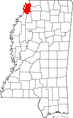 Map of Mississippi highlighting Tunica County | |
| CDPs |
| |
| Other unincorporated communities | ||
| Ghost towns | ||