Hégenheim
Hégenheim (French pronunciation: [eɡənaim]; German: Hegenheim; Alsatian: Hagena) is a commune in the Haut-Rhin department in Alsace in north-eastern France. It is adjacent to the Swiss town of Allschwil, and is part of the Basel urban area.
Hégenheim | |
|---|---|
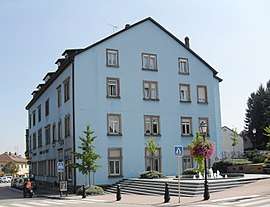 The town hall in Hégenheim | |
.svg.png) Coat of arms | |
Location of Hégenheim 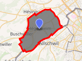
| |
 Hégenheim  Hégenheim | |
| Coordinates: 47°33′41″N 7°31′37″E | |
| Country | France |
| Region | Grand Est |
| Department | Haut-Rhin |
| Arrondissement | Mulhouse |
| Canton | Saint-Louis |
| Intercommunality | Trois Frontières |
| Government | |
| • Mayor (2008–2014) | Thomas Zeller |
| Area 1 | 6.7 km2 (2.6 sq mi) |
| Population (2017-01-01)[1] | 3,420 |
| • Density | 510/km2 (1,300/sq mi) |
| Time zone | UTC+01:00 (CET) |
| • Summer (DST) | UTC+02:00 (CEST) |
| INSEE/Postal code | 68126 /68220 |
| Elevation | 254–347 m (833–1,138 ft) |
| 1 French Land Register data, which excludes lakes, ponds, glaciers > 1 km2 (0.386 sq mi or 247 acres) and river estuaries. | |
Geography
Hégenheim is a village in Alsace next to the Swiss border. Basel is the nearest city, located few kilometers away. The landscape is a bit hilly because the village is situated near the Jura mountains.
Climate
| Climate data for Hégenheim, Upper-Rhine, France | |||||||||||||
|---|---|---|---|---|---|---|---|---|---|---|---|---|---|
| Month | Jan | Feb | Mar | Apr | May | Jun | Jul | Aug | Sep | Oct | Nov | Dec | Year |
| Record high °C (°F) | 18.0 (64.4) |
22.0 (71.6) |
25.5 (77.9) |
30.0 (86.0) |
33.5 (92.3) |
37.0 (98.6) |
37.8 (100.0) |
37.7 (99.9) |
32.9 (91.2) |
28.0 (82.4) |
24.0 (75.2) |
18.3 (64.9) |
37.8 (100.0) |
| Average high °C (°F) | 4.9 (40.8) |
7.0 (44.6) |
11.7 (53.1) |
16.1 (61.0) |
20.7 (69.3) |
23.9 (75.0) |
26.1 (79.0) |
26.0 (78.8) |
21.3 (70.3) |
15.9 (60.6) |
9.3 (48.7) |
5.2 (41.4) |
15.7 (60.2) |
| Daily mean °C (°F) | 2.1 (35.8) |
3.1 (37.6) |
6.9 (44.4) |
10.9 (51.6) |
15.2 (59.4) |
18.6 (65.5) |
20.7 (69.3) |
20.5 (68.9) |
16.1 (61.0) |
11.5 (52.7) |
6.1 (43.0) |
2.6 (36.7) |
11.2 (52.2) |
| Average low °C (°F) | −0.7 (30.7) |
−0.8 (30.6) |
2.1 (35.8) |
5.7 (42.3) |
9.6 (49.3) |
13.2 (55.8) |
15.2 (59.4) |
15.0 (59.0) |
10.9 (51.6) |
7.1 (44.8) |
2.9 (37.2) |
0.0 (32.0) |
6.7 (44.0) |
| Record low °C (°F) | −19.3 (−2.7) |
−20.0 (−4.0) |
−10.6 (12.9) |
−4.8 (23.4) |
−1.3 (29.7) |
2.0 (35.6) |
6.0 (42.8) |
4.5 (40.1) |
1.3 (34.3) |
−4.3 (24.3) |
−10.3 (13.5) |
−17.2 (1.0) |
−20.0 (−4.0) |
| Average precipitation mm (inches) | 43.4 (1.71) |
43.5 (1.71) |
46.5 (1.83) |
60.0 (2.36) |
93.0 (3.66) |
93.0 (3.66) |
93.0 (3.66) |
83.7 (3.30) |
66.0 (2.60) |
68.2 (2.69) |
66.0 (2.60) |
58.9 (2.32) |
815.2 (32.1) |
| Mean monthly sunshine hours | 72.5 | 86.8 | 126.2 | 152.9 | 175.3 | 235.0 | 224.5 | 214.6 | 159.4 | 128.0 | 72.6 | 55.0 | 1,702.8 |
| Source: Météo & Nature | |||||||||||||
Vegetation
Temperate broadleaf and mixed forests form the natural vegetation in Hégenheim. The climate is temperate, characterized by blossom trees in spring, green leaves in summer, yellow and red falling leaves in autumn, and bare branches in winter.
Trees that have thick trunks and broad leaves like the oak, elm, maple, beech and birch are commonly found here.
See also
- Communes of the Haut-Rhin département
- Château de Hegenheim
References
- "Populations légales 2017". INSEE. Retrieved 6 January 2020.
External links
| Wikimedia Commons has media related to Hégenheim. |
- Official site
- Travel Index guide (in French)
| Authority control |
|
|---|