Håland
Håland is a former municipality in Rogaland county, Norway. It was part of the traditional district of Jæren, just west of the city of Stavanger. The municipality existed from 1838 until its dissolution in 1930 when it was split into the two municipalities of Sola and Madla. The 85-square-kilometre (33 sq mi) municipality included the land surrounding the Hafrsfjorden including all of the present-day municipality of Sola and the borough of Madla in the city of Stavanger.[1]
Håland herred Haaland herred (historic) | |
|---|---|
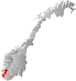 Rogaland within Norway | |
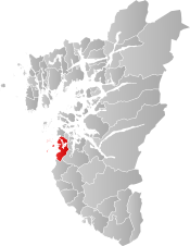 Håland within Rogaland | |
| Coordinates: 58°51′22″N 05°34′30″E | |
| Country | Norway |
| County | Rogaland |
| District | Jæren |
| Established | 1 Jan 1838 |
| Disestablished | 1 Jan 1930 |
| Administrative centre | Solakrossen |
| Area | |
| • Total | 85 km2 (33 sq mi) |
| *Area at municipal dissolution. | |
| Population (1930) | |
| • Total | 4,463 |
| • Density | 53/km2 (140/sq mi) |
| Time zone | UTC+01:00 (CET) |
| • Summer (DST) | UTC+02:00 (CEST) |
| ISO 3166 code | NO-1124 |
| Created as | Formannskapsdistrikt in 1838 |
| Succeeded by | Sola and Madla in 1930 |
History
The historic parish of Haaland (later spelled Håland) had included churches located in Sola, Tananger, Tjora, and Madla. On 1 January 1838, the parish of Haaland was established as a municipality (see formannskapsdistrikt law). Håland municipality existed until 1930, when it was split to form the two new municipalities of Madla (population: 1,091) and Sola (population: 3,372). Later, Madla was merged with the city of Stavanger and it now makes up the borough of Madla.[2]
References
- Store norske leksikon. "Håland" (in Norwegian). Archived from the original on 7 May 2016. Retrieved 19 April 2016.
- Jukvam, Dag (1999). "Historisk oversikt over endringer i kommune- og fylkesinndelingen" (PDF) (in Norwegian). Statistisk sentralbyrå.
 |
|  | |||||||||||||||||||||||||
||