Gurskøya
Gurskøya[1] is an island in Møre og Romsdal county, Norway. The 137-square-kilometre (53 sq mi) island is shared by the municipalities of Sande and Herøy. The villages of Gursken, Larsnes, and Moldtustranda are located on the island. The southern part of the island was historically part of the municipality of Rovde. In 2015, there were 4,647 residents living on the island.[2]
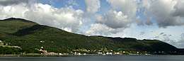 View of the Leikong area on the east coast of the island. | |
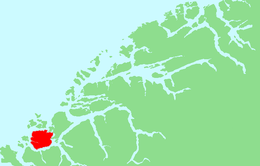 | |
 Gurskøya Location of the island  Gurskøya Gurskøya (Norway) | |
| Geography | |
|---|---|
| Location | Møre og Romsdal, Norway |
| Coordinates | 62.2086°N 5.6381°E |
| Area | 137 km2 (53 sq mi) |
| Length | 11 km (6.8 mi) |
| Width | 16.5 km (10.25 mi) |
| Highest elevation | 660 m (2,170 ft) |
| Highest point | Sollia |
| Administration | |
Norway | |
| County | Møre og Romsdal |
| Municipality | Herøy Municipality and Sande Municipality |
| Demographics | |
| Population | 4647 (2015) |
The island lies north of the Rovdestranda area on the mainland; southwest of the islands of Hareidlandet and Dimnøya, west of the island of Eika; east of the islands of Kvamsøya, Voksa, and Sandsøya; and south of the Norwegian Sea and the islands of Nerlandsøya, Bergsøya, Leinøya, and Flåvær.
The island is home to many fish-related industries such as fishing and fish processing.[2]
Notable residents
- Anne Leer, an author
- Anlaug Amanda Djupvik, an astronomer
References
- "Stadnamn og skrivemåten for stadnamn" (in Norwegian). Kartverket. Retrieved 2019-09-08.
- Thorsnæs, Geir, ed. (2015-09-10). "Gurskøya". Store norske leksikon (in Norwegian). Kunnskapsforlaget. Retrieved 2019-09-08.