Leinøya
Leinøya[1] is an island in the municipality of Herøy in Møre og Romsdal county, Norway. Its original name was Bølandet, but Leinøya is now the official name. The island is located east of the town of Fosnavåg on the nearby island of Bergsøya. The island is connected to several surrounding islands via a network of bridges. The Remøy Bridge connects it to the island Remøya (to the north), the Herøy Bridge connects it to Nautøya and Gurskøya (to the south), and a small bridge connects to the island of Bergsøya (to the west).
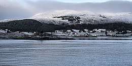 View of Torvik on the east coast of the island. | |
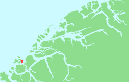 | |
 Leinøya Location of the island  Leinøya Leinøya (Norway) | |
| Geography | |
|---|---|
| Location | Møre og Romsdal, Norway |
| Coordinates | 62.3380°N 5.7015°E |
| Area | 14.4 km2 (5.6 sq mi) |
| Length | 5 km (3.1 mi) |
| Width | 4 km (2.5 mi) |
| Highest elevation | 364 m (1,194 ft) |
| Highest point | Leinehornet |
| Administration | |
Norway | |
| County | Møre og Romsdal |
| Municipality | Herøy Municipality |
| Demographics | |
| Population | 1479 (2015) |
The highest point on the island is Leinehornet which is 363 metres (1,191 ft) above sea level. The island has an area of 14.4 square kilometres (5.6 sq mi). The village of Torvik, on the east side of the island, is a stop on the Hurtigruten. In 2015, the island had 1,479 residents.[2]
See also
References
- "Stadnamn og skrivemåten for stadnamn" (in Norwegian). Kartverket. Retrieved 2019-09-08.
- Thorsnæs, Geir, ed. (2015-09-12). "Leinøya". Store norske leksikon (in Norwegian). Kunnskapsforlaget. Retrieved 2019-09-08.