Grade II* listed buildings in the London Borough of Richmond upon Thames
There are over 20,000 Grade II* listed buildings in England. This page is a list of these buildings in the London Borough of Richmond upon Thames.
Almshouses
| Name | Location | Type | Completed [note 1] | Date designated | Grid ref.[note 2] Geo-coordinates |
Entry number [note 3] | Image |
|---|---|---|---|---|---|---|---|
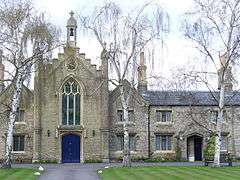
| Hickeys Almshouses, Including Chapel and Lodges | Sheen Road, Richmond TW9 1XB | Almshouses, chapel and lodges | 1834 | 10 January 1950 | TQ1886375104 51°27′45″N 0°17′25″W |
1262108 | |
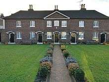
| Houblon's Almshouses | Worple Way, Richmond TW10 6DA | Almshouses | 1757–58 | 10 January 1950 | TQ1840674978 51°27′41″N 0°17′49″W |
1253033 |
Bridges
| Name | Location | Type | Completed [note 1] | Date designated | Grid ref.[note 2] Geo-coordinates |
Entry number [note 3] | Image |
|---|---|---|---|---|---|---|---|
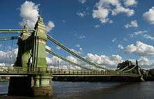
| Hammersmith Bridge | Castelnau | Suspension bridge | 1884 | 25 June 1983 | TQ2293878036 51°29′17″N 0°13′51″W |
1080793 | |
| Kingston Bridge | A308, Richmond KT1 4DP | Road bridge | 1825–28 | 2 September 1952 | TQ1769069379 51°24′40″N 0°18′33″W |
1065378 | |
| Richmond Footbridge, Lock and Sluices | Richmond | Footbridge and lock | 1891 | 25 May 1983 | TQ1701575056 51°27′45″N 0°19′01″W |
1250044 | |
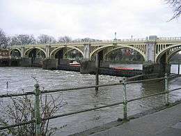
| Twickenham Bridge and Attached Railings, Lamp Standards and Light Brackets | A316, Richmond TW1 1QX | Road bridge | 1933 | 25 May 1983 | TQ1721274846 51°27′38″N 0°18′51″W |
1253011 | 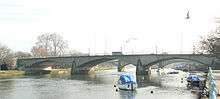 Twickenham Bridge and Attached Railings, Lamp Standards and Light Brackets |

Churches, memorials and tombs
| Name | Location | Type | Completed [note 1] | Date designated | Grid ref.[note 2] Geo-coordinates |
Entry number [note 3] | Image |
|---|---|---|---|---|---|---|---|
| Bethlehem Chapel | Church Terrace, Richmond TW10 6SE | Nonconformist chapel | 1797 | 24 December 1968 | TQ1793774712 51°27′33″N 0°18′14″W |
1358048 | |
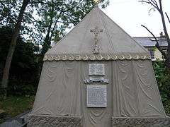
| The Kilmorey Mausoleum (including Enclosure Wall, Railings and Gate) | 275 St. Margarets Road, Twickenham TW1 1PN | Mausoleum, wall, railings and gate | 1854 | 6 October 1989 | TQ1660974904 51°27′40″N 0°19′22″W |
1240128 | |
| The Lancaster Monument, East Sheen Cemetery | Sheen Road, Richmond TW10 5BJ | Statue | 1920–22 | 5 March 1992 | TQ1928174762 51°27′33″N 0°17′04″W |
1239967 | |
| Mausoleum of Sir Richard and Lady Burton, Churchyard of St Mary Magdalen | 61 North Worple Way, Mortlake, London SW14 8PR | Mausoleum | c. 1890 | 30 October 1973 | TQ2086075792 51°28′06″N 0°15′41″W |
1065392 | |
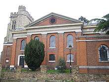
| St Alban | Ferry Road, Teddington TW11 9NN | Church | 1886 | 2 September 1952 | TQ1658671236 51°25′41″N 0°19′28″W |
1080819 | |
| St Anne | Kew Green, Kew, Richmond TW9 3AA | Parish church | 1714 | 10 January 1950 | TQ1898277484 51°29′02″N 0°17′16″W |
1194022 | |
| Churchyard of Church of St Anne, to East of Church (Tomb of Johan Zoffany) | Kew Green, Kew, Richmond TW9 3AA | Table tomb | 1816 | 25 June 1983 | TQ1901177489 51°29′02″N 0°17′15″W |
1357735 |  Churchyard of Church of St Anne, to East of Church (Tomb of Johan Zoffany) |
| Churchyard of Church of St Anne, to South of Church (Tomb of Thomas Gainsborough) | Kew Green, Kew, Richmond TW9 3AA | Tombstone | 1788 | 25 June 1983 | TQ1898377472 51°29′01″N 0°17′16″W |
1065407 |  Churchyard of Church of St Anne, to South of Church (Tomb of Thomas Gainsborough) |
| St Mary, Barnes | Church Road, Barnes, London SW13 9HL | Parish church | 13th century | 25 October 1951 | TQ2220276583 51°28′30″N 0°14′31″W |
1358083 | |
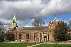
| St Mary the Virgin Mortlake | Mortlake High Street, London SW14 8JA | Parish church | 1348 | 25 October 1951 | TQ2084575941 51°28′10″N 0°15′42″W |
1357705 |  St Mary the Virgin Mortlake |
| St Mary Magdalene, Richmond | Church Walk, Richmond TW9 1SN | Church | Perpendicular | 10 January 1950 | TQ1793474829 51°27′37″N 0°18′14″W |
1180602 | |
| St Mary, Teddington | Ferry Road, Teddington TW11 9NN | Church | 16th century onwards | 2 September 1952 | TQ1652271278 51°25′43″N 0°19′31″W |
1253013 | |
| St Mary, Twickenham | Church Street, Twickenham TW1 3NJ | Church | 1714-5 | 2 September 1952 | TQ1648973328 51°26′49″N 0°19′30″W |
1080852 | |
| St Peter | Church Lane, off Petersham Road, Petersham TW10 7AB | Parish church | 1505 | 10 January 1950 | TQ1814573338 51°26′48″N 0°18′05″W |
1065334 | 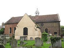 St Peter |
| Twickenham War Memorial | Radnor Gardens, Cross Deep, Twickenham, London, TW1 4QG | War memorial | 1921 | 5 April 2017 | TQ1604572566 51°26′25″N 0°19′54″W |
1445040 |


.jpg)
Royal Botanic Gardens, Kew
| Name | Location | Type | Completed [note 1] | Date designated | Grid ref.[note 2] Geo-coordinates |
Entry number [note 3] | Image |
|---|---|---|---|---|---|---|---|
| Aroid House | Royal Botanic Gardens, Kew, Richmond TW9 3AE | Pavilion | Reerected | 10 January 1950 | TQ1866177534 51°29′04″N 0°17′33″W |
1250800 | 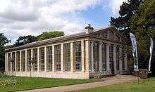 Aroid House |
| Avenue Lodge | Royal Botanic Gardens, Kew, Richmond TW9 3AE | Lodge | 1866 | 25 May 1983 | TQ1867676402 51°28′27″N 0°17′33″W |
1251933 |  Avenue Lodge |
| Marianne North Gallery | Royal Botanic Gardens, Kew, Richmond TW9 3AE | Art gallery | 1879–1882 | 10 January 1950 | TQ1868276431 51°28′28″N 0°17′33″W |
1251787 | |
| Principal Entrance Gates and Railings Fronting Kew Green (now known as Elizabeth Gate) | Royal Botanic Gardens, Kew, Richmond TW9 3AE | Gate | 1848 | 25 May 1983 | TQ1873877548 51°29′04″N 0°17′29″W |
1250801 | 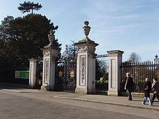 Principal Entrance Gates and Railings Fronting Kew Green (now known as Elizabeth Gate) |
| The Queen's Cottage | Royal Botanic Gardens, Kew, Richmond TW9 3AE | Timber-framed house | c. 1772 | 10 January 1950 | TQ1790776250 51°28′23″N 0°18′14″W |
1262486 |  The Queen's Cottage |
| Ruined Arch, Including Fragments of Masonry at the Base of the Arch | Royal Botanic Gardens, Kew, Richmond TW9 3AE | Folly | 1759 | 25 May 1983 | TQ1865476371 51°28′26″N 0°17′35″W |
1251956 |  Ruined Arch, Including Fragments of Masonry at the Base of the Arch |
| Herbarium Complex, Royal Botanic Gardens, Kew - Hunter House and Wings C, B and A, including the entrance gates and railings | Royal Botanic Gardens, Kew, Richmond TW9 3AE | Herbarium | various | 10 January 1950 | TQ1876977629 51°29′07″N 0°17′27″W |
1065399 | .jpg) Herbarium Complex, Royal Botanic Gardens, Kew - Hunter House and Wings C, B and A, including the entrance gates and railings |

Other buildings
| Name | Location | Type | Completed [note 1] | Date designated | Grid ref.[note 2] Geo-coordinates |
Entry number [note 3] | Image |
|---|---|---|---|---|---|---|---|
| Box Cottage (The Red House) | Sudbrook Lane, Petersham, Richmond TW10 7AT | House | Late 17th/early 18th century | 10 January 1950 | TQ1812073024 51°26′38″N 0°18′06″W |
1252876 |  |
| Buckingham House Dudley House Farthingwood and Gate and Railing Norfolk House | Montpelier Row, Twickenham TW1 2NQ | Terrace | 1720 | 2 September 1952 | TQ1700473765 51°27′03″N 0°19′03″W |
1065390 | |
| Bushy House | Bushy Road, Teddington TW11 0EB | House | Early 19th century | 2 September 1952 | TQ1557770357 51°25′14″N 0°20′21″W |
1080870 | |
| Cross Deep and Coach House | 3 Cross Deep, Twickenham TW1 1QY | House | Late 17th/early 18th century | 2 September 1952 | TQ1612972947 51°26′37″N 0°19′50″W |
1358068 | |
| Douglas House | Petersham Road, Petersham, Richmond TW10 7AH | House | Late 17th century | 25 June 1983 | TQ1787973156 51°26′42″N 0°18′19″W |
1285296 | |
| Entrance Gate and Piers to Rutland Lodge Rutland Lodge | 145 Petersham Road, Petersham, Richmond TW10 7AA | House | Late 17th century | 10 January 1950 | TQ1801173292 51°26′47″N 0°18′12″W |
1065338 |  Entrance Gate and Piers to Rutland Lodge Rutland Lodge |
| Fotheringay House and Tennyson House | Montpelier Row, Twickenham TW1 2NQ | Terrace | 1720 | 2 September 1952 | TQ1701373745 51°27′02″N 0°19′03″W |
1285639 | .jpg) Fotheringay House and Tennyson House |
| Fountain Garden, Statue in Front of Canal | Hampton Court | Statue | after 16th century statue | 2 September 1952 | TQ1600968410 51°24′10″N 0°20′01″W |
1065453 |  Fountain Garden, Statue in Front of Canal |
| Garden Gates and Railings Petersham House | Church Lane, Petersham, Richmond TW10 7AG | House | Late 17th century | 10 January 1950 | TQ1811073311 51°26′47″N 0°18′07″W |
1065336 |  Garden Gates and Railings Petersham House |
| Gate and Railings to Old Friars Old Friars | Richmond Green | Terraced house | Late 17th century | 10 January 1950 | TQ1765474833 51°27′37″N 0°18′28″W |
1065315 | |
| Gates and Railings to Oak House Oak House | Richmond Green, Richmond TW9 1NQ | Terraced house | Mid 18th century | 10 January 1950 | TQ1768374820 51°27′36″N 0°18′27″W |
1065313 | |
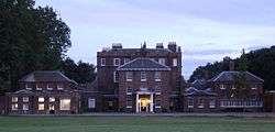
| Gordon House Maria Grey Training College | St Margarets | House | c. 1720 | 21 May 1973 | TQ1669375276 51°27′52″N 0°19′18″W |
1240076 |  Gordon House Maria Grey Training College |
| Grotto in Grounds of Hampton Court House | Hampton Court Road KT8 9BS | Grotto | Completed by 1769 | 18 February 1976 | TQ1527768984 51°24′29″N 0°20′38″W |
1253959 | |
| Grotto or Shell House in the Grounds of Thames Eyot | 3 Cross Deep, Twickenham TW1 1QY | Grotto | Late 18th century or early 19th century | 25 June 1983 | TQ1616572951 51°26′37″N 0°19′48″W |
1080812 | |
| Grove House including Moorish Room | 100 High Street, Hampton TW12 2ST[1] | House | Late 17th century | 2 February 1952 | TQ1426769909 51°25′00″N 0°21′29″W |
1357703 | |
| Harrington Lodge | Sudbrook Lane, Petersham TW10 7AT | House | Late C17/Early 18th century | 10 January 1950 | TQ1812573009 51°26′38″N 0°18′06″W |
1252875 | |
| Langham House Close, nos. 1–18 | Ham Common, Ham TW10 7JE | Flats | 1957–1958 | 22 December 1998 | TQ1760771851 51°26′00″N 0°18′34″W |
1033380 |  Langham House Close, nos. 1–18 |
| Langham House Close, nos. 19–24 | Ham Common, Ham TW10 7JE | Flats | 1957–1958 | 23 December 1998 | TQ1757871814 51°25′59″N 0°18′36″W |
1033381 | |
| Langham House Close, nos. 25–30 | Ham Common, Ham TW10 7JE | Flats | 1957–1958 | 22 December 1998 | TQ1754171772 51°25′58″N 0°18′38″W |
1051027 | |
| Leicester House Queen Anne House Wolsey House and Gate | Montpelier Row, Twickenham | Terrace | 1720 | 2 September 1952 | TQ1699073797 51°27′04″N 0°19′04″W |
1065389 | |
| Limes House and Forecourt Piers | 123 Mortlake High Street, London SW14 8SN[2] | House | c. 1720 | 25 October 1951[2] | TQ2113276050 51°28′14″N 0°15′27″W |
1065428 | |
| Lissoy | Ormond Road, Richmond TW10 6TH | Terraced house | Early 18th century | 10 January 1950 | TQ1785374611 51°27′30″N 0°18′18″W |
1065353 | |
| Manor House | Ham Street, Ham TW10 7HA | House | Early to mid 18th century | 10 January 1950 | TQ1729072605 51°26′25″N 0°18′50″W |
1358099 |  Manor House |
| Montpelier House South End House Walls, Piers, Railings and Gazebo in Grounds | Twickenham | Terrace | 18th century | 2 September 1952 | TQ1706673647 51°26′59″N 0°19′00″W |
1065391 | |
| Montrose House | 186, Petersham Road, Petersham, Richmond TW10 7AD | House | Late 17th century | 25 June 1983 | TQ1805473255 51°26′46″N 0°18′09″W |
1065342 | |
| Newark House | 9 The Vineyard, Richmond TW10 6AQ | House | Mid 18th century | 10 January 1950 | TQ1804474581 51°27′28″N 0°18′08″W |
1253134 | |
| Normansfield Hospital | Kingston Road, Teddington TW11 9JH | House | 1866 | 25 May 1983 | TQ1725970177 51°25′07″N 0°18′54″W |
1065379 | |
| No. 19, 21, and 23 Kew Foot Road | Richmond TW9 2SS | Terrace | c. 1711 | 10 January 1950 | TQ1806575452 51°27′57″N 0°18′06″W |
1065436 | |
| No. 356 and 358 Kew Road | Richmond | House | Early/mid 18th century | 10 January 1950 | TQ1906177329 51°28′57″N 0°17′12″W |
1357700 | |
| No. 18 King Street | Richmond TW9 1ND | Terraced house | Early 18th century | 10 January 1950 | TQ1769774830 51°27′37″N 0°18′26″W |
1065373 | |
| No. 6 Ormond Road | Richmond TW10 6TH | Terraced house | Early 18th century | 10 January 1950 | TQ1787774627 51°27′30″N 0°18′17″W |
1065356 | |
| No. 1 Richmond Green | Richmond TW9 1NQ | Terraced house | Early 18th century | 10 January 1950 | TQ1769874835 51°27′37″N 0°18′26″W |
1065311 | |
| No. 2-6 Richmond Green | Richmond | Terrace | Early 18th century | 10 January 1950 | TQ1770974850 51°27′37″N 0°18′25″W |
1065312 | 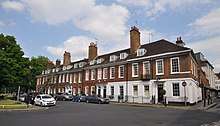 No. 2-6 Richmond Green |
| No. 10 Richmond Green | Richmond TW9 1PX | Terraced house | Early 18th century | 10 January 1950 | TQ1783074935 51°27′40″N 0°18′19″W |
1357746 | |
| No 11, and Railings | Richmond | Terraced house, and railings | 18th century | 10 January 1950 | TQ1782774931 51°27′40″N 0°18′19″W |
1065348 |  No 11, and Railings |
| No. 12 Richmond Green | Richmond TW9 1PX | Terraced house | 18th century | 10 January 1950 | TQ1782374926 51°27′40″N 0°18′19″W |
1181111 | |
| No. 32 Richmond Green | Richmond | Terraced house | Early 18th century | 10 January 1950 | TQ1772274868 51°27′38″N 0°18′25″W |
1357770 | |
| No. 3-12 Sion Road | Twickenham TW1 3DR | Terrace | Early 18th century | 2 September 1952 | TQ1668273396 51°26′51″N 0°19′20″W |
1262089 | |
| 18 Station Road | Barnes, London SW13 0LW | House | Earlier | 12 May 1950 | TQ2180176319 51°28′22″N 0°14′52″W |
1252850 | |
| Old Court House | The Wardrobe, Richmond TW9 1PB | House | Early 18th century | 9 February 1952 | TQ1756774959 51°27′41″N 0°18′33″W |
1181217 | |
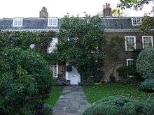
| Old Palace Place | The Green, Richmond TW9 1NQ | House | Late C16/C17 | 10 January 1950 | TQ1767374825 51°27′37″N 0°18′27″W |
1065314 |  Old Palace Place |
| Ormeley Lodge, with Gates and Railings to Front | Ham Gate Avenue, Ham, TW10 5HB | Country house | Late C17/Early 18th century | 10 January 1950 | TQ1807672051 51°26′07″N 0°18′10″W |
1286489 | |
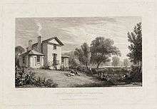
| Pope's Grotto in Grounds of St Catherine's High School | Twickenham | Grotto | C19-20 | 2 September 1952 | TQ1595672690 51°26′29″N 0°19′59″W |
1192178 |  Pope's Grotto in Grounds of St Catherine's High School |
| Richmond Theatre | Little Green, Richmond TW9 1QJ | Theatre | 1899 | 28 June 1972 | TQ1792875046 51°27′44″N 0°18′14″W |
1065384 | |
| Sandycombe Lodge | 40 Sandycoombe Road, Twickenham TW1 2LR | Studio house | Early 19th century | 2 September 1952 | TQ1708774105 51°27′14″N 0°18′59″W |
1262429 | |
| Seaforth House | Church Terrace, Richmond TW10 6SE | Terraced house | Early 18th century | 10 January 1950 | TQ1795874744 51°27′34″N 0°18′13″W |
1261555 | |
| Seymour House Warwick House | Montpelier Row, Twickenham TW1 2NQ | House | 1720 | 2 September 1952 | TQ1697473820 51°27′05″N 0°19′05″W |
1194493 | |
| Sion Cottage | Sion Road, Twickenham TW1 3DD | House | Early 18th century | 2 September 1952 | TQ1671173358 51°26′50″N 0°19′19″W |
1262088 | |
| Sion House, Railings and Piers | Sion Road, Twickenham TW1 3DD | House | Early 18th century | 2 September 1952 | TQ1670673360 51°26′50″N 0°19′19″W |
1252847 | |
| Sudbrook Cottage | Sudbrook Lane, Petersham TW10 7AT | House | Late C17/Early 18th century | 10 January 1950 | TQ1810873040 51°26′39″N 0°18′07″W |
1262065 | |
| Sudbrook Lodge | Petersham Road, Richmond TW10 5HA | House | Early 18th century | 10 January 1950 | TQ1793672133 51°26′09″N 0°18′17″W |
1253016 | |
| The Old Court House | Hampton Court Road, Hampton KT8 9BW | House | Early 18th century | 25 June 1983 | TQ1539768645 51°24′18″N 0°20′32″W |
1080796 | |
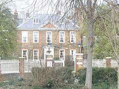
| The Old Vicarage School | 48 Richmond Hill, Richmond TW10 6QX | House | Extant c1680 | 24 December 1968 | TQ1806474399 51°27′23″N 0°18′08″W |
1249946 | 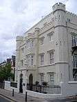 The Old Vicarage School |
| The Pavilion | Hampton Court Palace, East Molesey KT8 9AP | Bowling green pavilion | 1700–01 | 2 September 1952 | TQ1627167534 51°23′42″N 0°19′49″W |
1080801 | |
| The Terrace | 3 Richmond Hill, Richmond TW10 6RE | House | 1767 | 10 January 1950 | TQ1797474460 51°27′25″N 0°18′12″W |
1249952 |  The Terrace |
| Underground Passage at Radnor Lodge | Radnor Road, Twickenham | Grotto | 18th century | 25 June 1983 | TQ1578272840 51°26′34″N 0°20′08″W |
1065344 | |
| Underground Passage in Grounds of St Catherine's High School | Under the junction of Radnor Road and Grotto Road, Cross Deep, Twickenham TW1 4QJ | Grotto | 18th century | 25 June 1983 | TQ1580072823 51°26′33″N 0°20′07″W |
1080811 | |
| York House, Garden Walls Wrought Iron Gates and Boundary Walls Along Sion Road on the East Side and Riverside on the South | Richmond Road, Twickenham TW1 3AA | House | Earlier | 2 September 1952 | TQ1654273401 51°26′51″N 0°19′28″W |
1263365 | 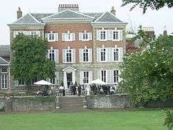 York House, Garden Walls Wrought Iron Gates and Boundary Walls Along Sion Road on the East Side and Riverside on the South |


See also
- Grade I listed buildings in Richmond upon Thames
Notes
- The date given is the date used by Historic England as significant for the initial building or that of an important part in the structure's description.
- Sometimes known as OSGB36, the grid reference is based on the British national grid reference system used by the Ordnance Survey.
- The "List Entry Number" is a unique number assigned to each listed building and scheduled monument by Historic England.
References
- "Grove House". Places. Twickenham Museum. Retrieved 13 August 2014.
- Historic England. "Limes House and Forecourt Piers (1065428)". National Heritage List for England. Retrieved 20 September 2016.
External links

This article is issued from Wikipedia. The text is licensed under Creative Commons - Attribution - Sharealike. Additional terms may apply for the media files.