Gajarkot
[Gajarkot] is a village development committee in Tanahu District in the Gandaki Zone of central Nepal. At the time of the 1991 Nepal census it had a population of 5385 people living in 983 individual households.It contains 9 wards. Ward No.: 1 »» Kathekot, Ward No.: 2 »» Katahre, Ward No.: 3 »» Dumkot, Ward No.: 4&5 »» Putgau & Puttar, Ward No.: 6 »» Attrouli, Ward No.: 7 »» Baindi, Ward No.: 8 »» Gajarkot., & Ward No.: 9 »» Dumrebesi.
Gajarkot गाजरकोट | |
|---|---|
 Gajarkot Location in Nepal | |
| Coordinates: 27.88°N 83.98°E | |
| Country | |
| Zone | Gandaki Zone |
| District | Tanahu District |
| Population (1991) | |
| • Total | 5,385 |
| Time zone | UTC+5:45 (Nepal Time) |
The community here consist of mixed type. Magar and Newar are in majority in Kathekot and Dumkot while Brahman and Kshetri are in majority in Baindi, Dumribesi, Atrouli and Puttar. A cannel from local Maidi Khola is dug that irrigates the plain land of Baindi, Bhantar, Atrouli and Puttar. A small cannel (Nahar) dug by the Khanal family around 2020 BS irrigates the fields of Baindi.
References
- "Nepal Census 2001", Nepal's Village Development Committees, Digital Himalaya, archived from the original on 12 October 2008, retrieved 15 November 2009.
External links
Headquarters: Damauli (today part of Byas Municipality) | ||
| Municipalities | 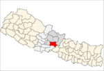 | |
| Rural municipalities | ||
| Former VDCs |
| |