Göhrde
Göhrde is a municipality in the district of Lüchow-Dannenberg, in Lower Saxony, Germany.
Göhrde | |
|---|---|
Location of Göhrde within Lüchow-Dannenberg district 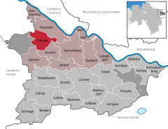  | |
 Göhrde 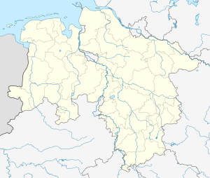 Göhrde | |
| Coordinates: 53°09′N 10°53′E | |
| Country | Germany |
| State | Lower Saxony |
| District | Lüchow-Dannenberg |
| Municipal assoc. | Elbtalaue |
| Subdivisions | 12 Ortsteile |
| Government | |
| • Mayor | Dietmar Harlfinger (FDP) |
| Area | |
| • Total | 40.71 km2 (15.72 sq mi) |
| Elevation | 77 m (253 ft) |
| Population (2018-12-31)[1] | |
| • Total | 581 |
| • Density | 14/km2 (37/sq mi) |
| Time zone | CET/CEST (UTC+1/+2) |
| Postal codes | 29473 |
| Dialling codes | 05862 |
| Vehicle registration | DAN |
The municipality was named after the Göhrde State Forest, which has an area of about 75 square kilometres (29 sq mi), famous for its oaks, beeches and game preserves. The hunting lodge situated in the forest was built in 1689 and was restored by Ernest Augustus, King of Hanover. It is known to history on account of the constitution of Gohrde, promulgated here in 1719.
It is also notable for the Battle of the Göhrde on 16 September 1813 during the War of the Sixth Coalition, in which Allied forces under Wallmoden defeated the French forces commanded by Pecheux.
![]()
Towns and municipalities in Lüchow-Dannenberg (district) | ||
|---|---|---|
Coat of arms | ||
References
| Authority control |
|
|---|