Fort Randall Dam
Fort Randall Dam is a 2.03 mi (3 km) long earthen dam which spans the Missouri River and impounds Lake Francis Case, the 11th largest reservoir in the U.S.[2] The dam joins Gregory and Charles Mix County, South Dakota a distance of 880 river miles (1,416 km) upstream of St. Louis, Missouri, where the river joins the Mississippi River. The dam and Hydroelectric power plant were constructed by and are currently operated by the U.S. Army Corps of Engineers.
| Fort Randall Dam | |
|---|---|
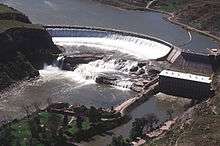
 Fort Randall Dam and Power Plant, with Lake Francis Case in the background. | |
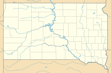 Location of Fort Randall Dam in the State of South Dakota. | |
| Country | United States |
| Location | Gregory County and Charles Mix County, South Dakota. |
| Coordinates | 43.066722°N 98.553897°W |
| Purpose | Flood Control, Hydroelectric Power, Irrigation, Water Supply, River Navigation, and recreation.[1] |
| Status | Operational |
| Construction began | 1946 |
| Opening date | 1953 |
| Construction cost | $200 million |
| Owner(s) | |
| Dam and spillways | |
| Type of dam | Rolled-earth fill |
| Impounds | Missouri River |
| Height | 165 ft (50 m) |
| Length | 10,700 ft (3,261 m) (including spillway) |
| Spillways | 21 40-foot x 29-foot tainter gates |
| Reservoir | |
| Creates | Lake Francis Case |
| Total capacity | 5,418,000 acre⋅ft (6.683004596×10⁹ m3) |
| Catchment area | 14,150 sq mi (36,648 km2) |
| Surface area | 102,000 acres (41,000 ha) |
| Maximum length | 107 mi (172 km) |
| Maximum water depth | 140 ft (43 m) |
| Normal elevation | 1,350 feet msl – 1,375 feet msl |
| Power Station | |
| Operator(s) | U.S. Army Corps of Engineers |
| Website U.S. Army Corps of Engineers - Fort Randall Project | |
History & background
Fort Randall Dam was authorized by the Flood Control Act of 1944 and plays a key role in the Pick-Sloan Plan for development of water resources in the Missouri River basin. The U.S. Army Corps of Engineers began construction of the dam in 1946, and was the first Pick-Sloan dam completed by the Omaha District. President Dwight D. Eisenhower threw the switch that started the first power generating unit in 1954. When completed in 1956, Fort Randall Dam and the Lake Francis Case Project cost approximately $200 million. U.S. Route 18 and U.S. Route 281 cross the crest of the dam. The dam is just over 3 mi (5 km) north of the Nebraska state line.
The Fort Randall Dam is located within sight of its namesake Fort Randall, an early U.S. Army Frontier Post. Fort Randall Dam is one of six Missouri River mainstem dams, the next dam upstream is Big Bend Dam, near Ft. Thompson and the next dam downstream is Gavins Point Dam, near Yankton.
Hydroelectric Power
The eight generating units of the Fort Randall Dam are capable of generating 40 megawatts of electricity each, with an annual production of 1.727 billion kilowatt hours.[3] The combined maximum capacity of 320 megawatts is enough to supply 245,000 households, according to the Corps of Engineers. The river behind the dam drains an area of 263,480 mi² (682,410 km²). Its reservoir, Lake Francis Case, has a surface area of 102,000 acres (41,000 ha) at maximum operating pool, coinciding with a volume of 5,700,000 acre feet (7.0×10⁹ m3).
2011 Missouri River Flood
In June 2011, in response to the 2011 Missouri River Floods, the dam was releasing over 143,000 cubic feet per second (4,000 m3/s), which greatly exceeded its previous record release of 67,000 cu ft/s (1,900 m3/s) set in 1997.[4]
Visitor Center
The Fort Randall Visitor Center is located on the western edge of Pickstown, South Dakota along U.S. Highway 281 and 18.[5] Open from Memorial Day through Labor Day, the visitor center offers a view of Fort Randall Dam, Lake Francis Case and the Missouri River. Exhibits highlight the dam's construction, area natural and cultural history and paleontology. There is also a freshwater aquarium with fish species found in the Missouri River.
See also
References
- http://www.nwo.usace.army.mil/Media/Fact-Sheets/Fact-Sheet-Article-View/Article/487642/fort-randall-project-statistics/
- http://www.nwo.usace.army.mil/Media/Fact-Sheets/Fact-Sheet-Article-View/Article/487642/fort-randall-project-statistics/
- "Summary of Engineering Data – Missouri River Main Stem System" (PDF). Missouri River Division. U.S. Army Corps of Engineers. August 2010. Retrieved 2012-08-17.
- "Missouri River Mainstem Reservoir Bulletin" (pdf). Army Corps of Engineers. Retrieved 18 June 2011.
- "Fort Randall Dam & Lake Francis Case". U.S. Army Corps of Engineers. Retrieved 17 December 2014.
External links

- Fort Randall Dam & Lake Francis Case - U.S. Army Corps of Engineers
Dams on the Missouri River | ||
|---|---|---|
 | ||
Crossings of the Missouri River | ||||
|---|---|---|---|---|
| ||||