Figueroa Street
Figueroa Street is a major north-south street in Los Angeles County, California, spanning from the Los Angeles neighborhood of Wilmington north to Eagle Rock.
 Figueroa Street sign in Los Angeles | |
| Namesake | José Figueroa |
|---|---|
| Maintained by | Los Angeles County Department of Public Works |
| Length | 25.00 mi (40.23 km) |
| Coordinates | 34°2′59″N 118°15′34″W |
| South end | Harry Bridges Boulevard in San Pedro |
| Major junctions |
|
| North end | Chevy Chase Drive in La Cañada Flintridge |

The street is named for General José Figueroa (1792 – September 29, 1835), governor of Alta California from 1833 to 1835, who oversaw the secularization of the missions of California.
Route

One of the longer streets in the city, it runs in a north/south direction for more than 30 miles (48 km) from its southern terminus at Harry Bridges Boulevard in the Wilmington neighborhood to Chevy Chase Drive in the city of La Cañada Flintridge at the north end.
From its south end at Harry Bridges Boulevard to Downtown Los Angeles, Figueroa Street runs north parallel to the Harbor Freeway (Interstate 110) in South Los Angeles. The only portion of this segment of Figueroa Street that lies outside Los Angeles city limits is in the city of Carson. South of the Los Angeles Financial District, Figueroa Street passes well-known locations including the University of Southern California, the Los Angeles Convention Center, and Staples Center/L.A. Live.
After passing through downtown Los Angeles near Bunker Hill and South Park, the southern portion of Figueroa Street ends near the overcrossing of Sunset Boulevard over the Arroyo Seco Parkway (SR 110) in Chinatown. The northern portion of the street resumes at San Fernando Road in Cypress Park. An early routing of Figueroa Street in this area was originally part of U.S. Route 66, today a part of the Arroyo Seco Parkway (State Route 110). The noted Figueroa Street Tunnels were once a part of that same stretch of roadway.
After resuming at San Fernando Road, Figueroa continues to run roughly parallel to the Arroyo Seco Parkway until it reaches York Boulevard in Highland Park. Afterwards, it heads north to its terminus near the Scholl Canyon Landfill just past its junction with the Ventura Freeway (State Route 134) in Eagle Rock. A short, unconnected continuation of Figueroa Street runs from a residential area just south of Marengo Drive in Glendale to end at Chevy Chase Drive just over the city limit line in La Cañada Flintridge.
Early maps produced by the Automobile Club of Southern California measured distances to Los Angeles from the club's headquarters at the intersection of Figueroa Street with Adams Boulevard.[1]
On April 2, 2011, a portion of Figueroa Street at Jefferson Boulevard was blocked off for the "Orange Carpet" and the grandstand for the broadcasting of the 2011 Kids' Choice Awards.
History
Figueroa was originally called Calle de los Chapules (or Grasshopper Street). Later in the 1880s it became known as "Pearl Street". The section of what is now Figueroa in Highland Park above Avenue 39 was known as "Pasadena Avenue" until Figueroa was extended through Elysian Park. The portion of what is now Figueroa between the Los Angeles River and Avenue 39 was originally known as Dayton Avenue until the Arroyo Parkway went through.[2]
Education
- Luther Burbank Middle School
- Florence Nightingale Middle School
- Optimist High School
- Sycamore Grove School
- University of Southern California
Transportation
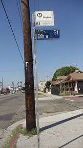
The Metro C and J lines operates a station underneath Interstate 105 at Figueroa Street. Metro Local Line 81 operates on Figueroa Street between Colorado Boulevard and Interstate 105 and Torrance Transit Line 1 between Interstate 105 and the Harbor Gateway Transit Center. The Metro E Line has 5 stations nearby. Two of which are shared with the Metro A Line, one being a major hub connecting to the Metro B and D lines. The Metro J Line runs on Figueroa Street in Gardena and between 23rd and 6th Streets in Downtown: Northbound J line trips to El Monte Bus Station continue north on Figueroa Street to serve the 7th Street / Metro Center and finally turn right on 6th street, leaving Figueroa Street. Southbound J Line trips to Harbor Gateway Transit Center or San Pedro run south on Flower Street from 5th Street to the Harbor Transitway. There are 6 J Line street stops located on Figueroa Street: Figueroa/190th/Victoria; Northbound only: Figueroa/23rd, Figueroa/Washington, Figueroa/Pico, Figueroa/Olympic, and Figueroa/7th . In addition, there are 7 Metro Silver Line Stations served on the Harbor Transitway and Harbor Freeway close to Figueroa Street: 37th Street/USC, Slauson, Manchester, Harbor Freeway, Rosecrans, Carson, and Pacific Coast Hwy. The Harbor Transitway is located on the I-110 freeway, between Figueroa Street and Broadway. The Lincoln/Cypress Station for the Metro L Line on Avenue 26 at its intersection with Lacy Street is about a 5-minute walk from Figueroa Street.
"My Figueroa" development plan and 2028 Summer Olympics
The Figueroa Corridor Streetscape project is a city led effort to beautify and improve the boulevard by adding pedestrian friendly amenities. The beautification project began on 7th street in Downtown Los Angeles, by Staples Center and terminates at Exposition Park at USC. The project began in 2017 and was completed by the end of 2018.[3] It aimed to improve transit and pedestrian access, protected bike lanes totally protected by physical barriers, a more organized and efficient street by adding better signalization and signage, high-visibility crosswalks, transit platforms, more street trees, public art and wider sidewalks. The $20 million Figueroa Corridor Streetscape project was funded by a Proposition 1C grant.[4] After delays, work was expected to commence in the summer of 2016[5] and was expected to be completed by March 2017, when the prop 1C grant expires.[6] The Los Angeles 2028 organizing committee plan to use this corridor as a planned "Live Site", an area dedicated as a central pedestrian corridor, linking all of the Downtown LA venues together during the 2028 Olympic & Paralympic Games.[7]
Notable landmarks
- Automobile Club of Southern California
- Banc of California Stadium
- Bob Hope Patriotic Hall
- Bonaventure Hotel
- Eagle Rock Historical Landmark
- Engine Co. 28 (1912 fire station)
- Exposition Park, including an historic palm tree moved there in 1914
- Hotel Figueroa (opened 1926, originally for women only)
- Flower Drive Historic District[8][9]
- Galen Center
- The Grammy Museum
- Highland Park Adult Senior Citizen Center
- Jonathan Club
- L.A. Live
- Los Angeles Convention Center
- Los Angeles County Health Department
- Los Angeles Memorial Coliseum
- Original Pantry Cafe
- St. Vincent de Paul Church
- Staples Center
- Stimson House
- State Bar of California
- University of Southern California
- Variety Arts Center Building
- Wilshire Grand Tower
Buildings on Figueroa
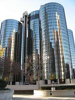 Bonaventure Hotel, 404 South Figueroa
 Jonathan Club, 545 South Figueroa
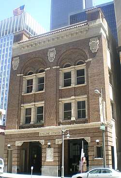 Engine Co. 28, 644 South Figueroa (1912 fire station)
 HSBC Building at Seventh Street, 2012
 Original Pantry Cafe, 9th Street and Figueroa
.jpg) Variety Arts Center Building, 938-940 South Figueroa, 1980, Julius Shulman photo
Variety Arts Center Building, 938-940 South Figueroa, 1980, Julius Shulman photo Hotel Figueroa, 939 South Figueroa (photo 2009)
 Los Angeles Convention Center at Pico Boulevard and Figueroa
 Bob Hope Patriotic Hall, 1816 South Figueroa
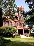 Stimson House (1891), 2421 South Figueroa
.jpg) St Vincent de Paul Catholic Church, Figueroa at Adams Boulevard (NorthWest corner)
St Vincent de Paul Catholic Church, Figueroa at Adams Boulevard (NorthWest corner)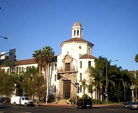 Automobile Club of Southern California, Figueroa at Adams Boulevard (SouthWest corner)
 Felix Chevrolet (iconic neon sign), Figueroa at Jefferson Boulevard (photo: John Margolies, 1977)
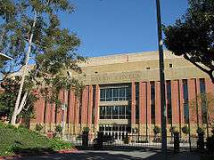 Galen Center on the USC campus at Jefferson Boulevard, 2007
 Banc of California Stadium, Exposition Park, and historic palm tree
References
- See Route 66: Traveler's Guide and Roadside Companion by Tom Snyder for examples
- Lucas, Greg (2011-09-29). "The Streets of Los Angeles". California's Capitol. Retrieved 2017-05-16.
Grasshopper Street – Calle de los Chapules – is now Figueroa which, in turn, is a tip of the hat to the former Mexican Governor Jose Figueroa.
- http://www.myfigueroa.com/blog
- "California Proposition 1C, Bonds for Housing (2006)". Retrieved 2017-05-16.
- Barragan, Bianca (2016-06-10). "Bikeable, Walkable Figueroa Actually Is Coming Soon". Curbed. Retrieved 2017-05-16.
- "What is MyFig?". myfigueroa.com. Retrieved 2017-05-16.
- "Stage 1: Vision, Games Concept and Strategy" (PDF). la24.org. 2016-02-12. Retrieved 2017-05-16.
- https://www.latimes.com/local/lanow/la-me-ln-fig-project-20190214-story.html
- http://www.parks.ca.gov/pages/1067/files/shrc_07-25-08.pdf
External links
| Wikimedia Commons has media related to Figueroa Street. |