Erwin, North Carolina
Erwin, formerly named Duke, is a town that is located in the eastern part of Harnett County, North Carolina, United States, located 8 miles from Dunn, North Carolina and approximately 33 miles from Fayetteville, North Carolina. It is a part of the Dunn, NC Micropolitan Statistical Area, which is additionally a part of the greater Raleigh-Durham-Cary, NC CSA, according to the United States Census Bureau. Currently, it has a population of 4,405 as of the 2010 census,[6] and more recently, in 2018, the population was 5,078.[7] Its current mayor is Patsy Carson, who has been the mayor since c. 2005.[8]
Erwin, North Carolina | |
|---|---|
 Downtown Erwin | |
| Motto(s): "Front Porch Friends"[1] | |
 Location of Erwin, North Carolina | |
| Coordinates: 35°19′22″N 78°40′19″W | |
| Country | United States |
| State | North Carolina |
| County | Harnett |
| Government | |
| • Mayor | Patsy Carson |
| Area | |
| • Total | 4.25 sq mi (11.02 km2) |
| • Land | 4.22 sq mi (10.92 km2) |
| • Water | 0.04 sq mi (0.10 km2) |
| Elevation | 187 ft (57 m) |
| Population (2010) | |
| • Total | 4,405 |
| • Estimate (2019)[3] | 5,156 |
| • Density | 1,222.96/sq mi (472.21/km2) |
| Time zone | UTC-5 (Eastern (EST)) |
| • Summer (DST) | UTC-4 (EDT) |
| ZIP code | 28339 |
| Area code(s) | 910 |
| FIPS code | 37-21740[4] |
| GNIS feature ID | 1020169[5] |
| Website | www |
History
Prior to Erwin, there was a colonial-era settlement in the area known as "Averasboro". The Battle of Averasborough was fought nearby during the American Civil War. In 1904, the Duke family built the Erwin Cotton Mill, which closed in 2000. The new town was named "Duke" after the founding shareholders. In 1925, the name was changed to "Erwin" because of the formation of Duke University in Durham, North Carolina.[9] Oak Grove, Averasboro Battlefield Historic District, and Downtown Erwin [10] are listed on the National Register of Historic Places.[11]
Geography
According to the United States Census Bureau, the town of Erwin has a total area of 4.23 square miles (10.95 km2), of which 0.04 square miles (0.10 km2), or 0.91%, are water.[6] The Cape Fear River forms part of the western border of the town.
Transportation
By road
![]()
![]()
![]()
![]()
![]()
![]()
![]()
![]()
By air
Harnett Regional Jetport is the only airport in the city, which is 10 miles near Buies Creek, NC. The airport currently does not support any airlines yet.
RDU Airport - Although not in the city, the airport serves the Triangle area, which includes Erwin. Carpool services, such as Uber or Lyft are available from the airport to the city.
Education
Public school
High school
Middle school
Coats Erwin Middle
Elementary school
Erwin Elementary - Merged with Gentry Primary temporarily until 2021, where it will return to its main grounds.[12]
Demographics
| Historical population | |||
|---|---|---|---|
| Census | Pop. | %± | |
| 1950 | 3,344 | — | |
| 1960 | 3,183 | −4.8% | |
| 1970 | 2,852 | −10.4% | |
| 1980 | 2,828 | −0.8% | |
| 1990 | 4,061 | 43.6% | |
| 2000 | 4,537 | 11.7% | |
| 2010 | 4,405 | −2.9% | |
| Est. 2019 | 5,156 | [3] | 17.0% |
| U.S. Decennial Census[13] | |||
As of the census[4] of 2000, there were 4,537 people, 1,896 households, and 1,287 families residing in the town. The population density was 1,128.8 people per square mile (435.8/km2). There were 2,032 housing units at an average density of 505.6 per square mile (195.2/km2). The racial makeup of the town was 80.63% White, 15.96% African American, 0.55% Native American, 0.09% Asian, 1.79% from other races, and 0.99% from two or more races. Hispanic or Latino of any race were 4.14% of the population.
There were 1,896 households, out of which 29.2% had children under the age of 18 living with them, 50.9% were married couples living together, 12.5% had a female householder with no husband present, and 32.1% were non-families. 28.3% of all households were made up of individuals, and 14.9% had someone living alone who was 65 years of age or older. The average household size was 2.38 and the average family size was 2.90.
In the town, the population was spread out, with 23.7% under the age of 18, 6.9% from 18 to 24, 27.9% from 25 to 44, 23.5% from 45 to 64, and 17.9% who were 65 years of age or older. The median age was 39 years. For every 100 females, there were 90.9 males. For every 100 females age 18 and over, there were 89.0 males.
The median income for a household in the town was $29,521, and the median income for a family was $41,270. Males had a median income of $29,610 versus $22,650 for females. The per capita income for the town was $18,282. About 16.4% of families and 20.7% of the population were below the poverty line, including 22.2% of those under age 18 and 31.3% of those age 65 or over.
Erwin includes three schools: Gentry Primary, Erwin Elementary, and Triton High School.
Water Tower
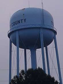
In early 2012, Erwin became home to the tallest sphere-topped water tower. The 219.75-foot (66.98 m) structure is about eight feet (2.4 m) taller than the previous record holder, the Union Watersphere in Union, New Jersey.[14] However, photographs of the Erwin water tower revealed the new tower to be a water spheroid, not an actual water sphere (see picture below).[15]
Notable people
- Al Woodall, NFL quarterback
References
- "Erwin North Carolina". Town of Erwin. Retrieved December 13, 2017.
- "2019 U.S. Gazetteer Files". United States Census Bureau. Retrieved July 27, 2020.
- "Population and Housing Unit Estimates". United States Census Bureau. May 24, 2020. Retrieved May 27, 2020.
- "U.S. Census website". United States Census Bureau. Retrieved 2008-01-31.
- "US Board on Geographic Names". United States Geological Survey. 2007-10-25. Retrieved 2008-01-31.
- "Geographic Identifiers: 2010 Census Summary File 1 (G001): Erwin town, North Carolina". American Factfinder. U.S. Census Bureau. Archived from the original on February 13, 2020. Retrieved December 13, 2017.
- "Population and Housing Unit Estimates". Retrieved October 8, 2019.
- "Erwin Mayor To Run Again". The Daily Record. Retrieved 2018-12-04.
- "Discover Erwin". Town of Erwin, North Carolina. Retrieved December 13, 2017.
- United States Department of the Interior, National Park Service, National Register of Historic Places. "Erwin Commercial Historic District" (PDF). North Carolina State Historic Preservation Office.
- "National Register Information System". National Register of Historic Places. National Park Service. July 9, 2010.
- Staff, tom woerner Of the Record. "Architect approved for new Erwin school". The Daily Record. Retrieved 2019-10-06.
- "Census of Population and Housing". Census.gov. Retrieved June 4, 2015.
- Rose, Lisa (February 22, 2012), "Despite challenge, Union Township water tower remains a Jersey landmark", The Star-Ledger, retrieved 2012-02-21
- "World's Tallest Water Sphere Title Safe for Now". Retrieved 2012-08-20.
External links
Municipalities and communities of Harnett County, North Carolina, United States | ||
|---|---|---|
| City |  | |
| Towns | ||
| Townships | ||
| CDPs | ||
| Unincorporated communities | ||
| Footnotes | ‡This populated place also has portions in an adjacent county or counties | |
| Authority control |
|
|---|