Duran, Gers
Duran is a commune in the Gers department in southwestern France.
Duran | |
|---|---|
.JPG) The village of Duran | |
.svg.png) Coat of arms | |
Location of Duran 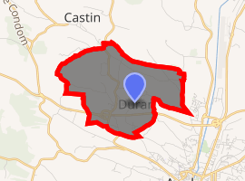
| |
 Duran  Duran | |
| Coordinates: 43°40′09″N 0°34′03″E | |
| Country | France |
| Region | Occitanie |
| Department | Gers |
| Arrondissement | Auch |
| Canton | Gascogne-Auscitaine |
| Intercommunality | Grand Auch |
| Government | |
| • Mayor (2008–2014) | Gilbert Ulian |
| Area 1 | 6.59 km2 (2.54 sq mi) |
| Population (2017-01-01)[1] | 870 |
| • Density | 130/km2 (340/sq mi) |
| Time zone | UTC+01:00 (CET) |
| • Summer (DST) | UTC+02:00 (CEST) |
| INSEE/Postal code | 32117 /32810 |
| Elevation | 137–256 m (449–840 ft) (avg. 219 m or 719 ft) |
| 1 French Land Register data, which excludes lakes, ponds, glaciers > 1 km2 (0.386 sq mi or 247 acres) and river estuaries. | |
Geography
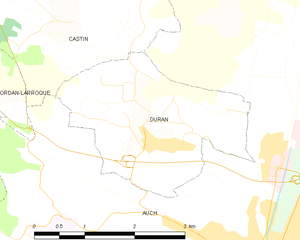
Duran and its surrounding communes
Population
| Year | Pop. | ±% |
|---|---|---|
| 1793 | 325 | — |
| 1800 | 245 | −24.6% |
| 1806 | 316 | +29.0% |
| 1821 | 321 | +1.6% |
| 1831 | 287 | −10.6% |
| 1841 | 326 | +13.6% |
| 1851 | 266 | −18.4% |
| 1861 | 281 | +5.6% |
| 1872 | 224 | −20.3% |
| 1881 | 200 | −10.7% |
| 1891 | 178 | −11.0% |
| 1901 | 156 | −12.4% |
| 1911 | 165 | +5.8% |
| 1921 | 146 | −11.5% |
| 1931 | 141 | −3.4% |
| 1946 | 138 | −2.1% |
| 1954 | 169 | +22.5% |
| 1962 | 205 | +21.3% |
| 1968 | 343 | +67.3% |
| 1975 | 450 | +31.2% |
| 1982 | 515 | +14.4% |
| 1990 | 650 | +26.2% |
| 1999 | 665 | +2.3% |
| 2009 | 810 | +21.8% |
| 2011 | 835 | +3.1% |
See also
References
- "Populations légales 2017". INSEE. Retrieved 6 January 2020.
| Wikimedia Commons has media related to Duran (Gers). |
| Authority control |
|
|---|
This article is issued from Wikipedia. The text is licensed under Creative Commons - Attribution - Sharealike. Additional terms may apply for the media files.