Dordogne (river)
The Dordogne (Occitan: Dordonha, French: La Dordogne) is a river in south-central and southwest France. The Dordogne and its watershed were designated Biosphere Reserve by UNESCO on July 11 2012.[1]
| Dordogne | |
|---|---|
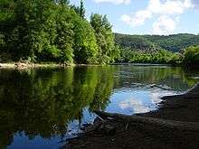
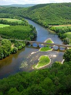 The Dordogne in Périgord, near Castelnaud-la-Chapelle | |
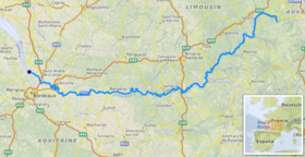 Location of the Dordogne in France | |
| Native name | La Dordogne |
| Location | |
| Country | France |
| Physical characteristics | |
| Source | |
| • location | Massif Central |
| • elevation | 1,720 m (5,640 ft) |
| Mouth | |
• location | Gironde estuary |
• coordinates | 45°2′29″N 0°36′24″W |
| Length | 483 km (300 mi) |
| Basin size | 23,870 km2 (9,220 sq mi) |
| Discharge | |
| • average | 450 m3/s (16,000 cu ft/s) |
Geography
The river rises on the flanks of the Puy de Sancy at 1,885 metres (6,184 ft) above sea level in the mountains of Auvergne, from the confluence of two small torrents above the town of Le Mont-Dore: the Dore and the Dogne. It flows generally west about 500 kilometres (310 mi) through the Limousin and Périgord regions before flowing into the Gironde, its common estuary with the Garonne, at the Bec d'Ambès ("Ambès beak"), north of the city of Bordeaux.
Nature
The Dordogne is one of the few rivers in the world that exhibit the phenomenon of a tidal bore, known as a mascaret.[2]
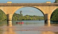
The upper valley of the Dordogne is a series of deep gorges. The cliffs, steep banks, fast flowing water and high bridges attract both walkers and drivers. In several places the river is dammed to form long, deep lakes. Camp sites and holiday homes have proliferated wherever the valley floor is wide enough to accommodate them.
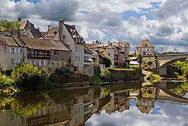
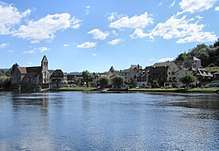
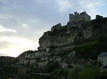
Below Argentat and around Beaulieu-sur-Dordogne, the valley widens to accommodate fertile farmland, well-watered pasture and orchards. In the towns, which are major tourist attractions because of their history and architecture, the quaysides are lined with eating and drinking places. In Périgord, the valley widens further to encompass one of France's main gastronomic regions, with vineyards, poultry farms and truffle-rich woodlands.
The main season for tourism in the Valley of the Dordogne is from June to September, with July and August being high season. The lifestyle and culture of the Dordogne valley attract both visitors and incomers from all over France, but also from many other countries, particularly Britain and Germany.
Course
The départements of France through which the Dordogne runs, together with some towns in those départements that are on or quite near the river, are as follows:
- The département of Puy-de-Dôme – The towns of Le Mont-Dore (near the source of the river) and La Bourboule;
- The département of Corrèze – The towns of Argentat, Bort-les-Orgues, and Beaulieu-sur-Dordogne;
- The département of Lot – The towns of Souillac, Pinsac, Lacave, Meyronne, Creysse, Montvalent, Martel, Floirac, Carennac, Gintrac, Tauriac and Prudhomat;
- The département of Dordogne – The towns of Beynac-et-Cazenac, Sarlat, Saint-Cyprien, and Bergerac;
- The département of Gironde – The towns of Sainte-Foy-la-Grande and Libourne.
Tributaries
Main tributaries from source to mouth:
- (R) Chavanon;
- (L) Rhue;
- (R) Diège;
- (L) Sumène;
- (R) Triouzoune;
- (L) Auze;
- (R) Luzège;
- (R) Doustre;
- (L) Maronne;
- (L) Cère;
- (R) Sourdoire;
- (L) Ouysse;
- (L) Céou;
- (R) Vézère along which many of the great prehistoric caves of Southwest France are located;
- (R) Isle;
- (L) Laurence.
N.B. : (R) = right tributary; (L) = left tributary
Activities
Aside from the usual activities such as tennis and golf available in many areas of France, there are a number of water-related activities related to the Dordogne, including:
- Fishing, an age-old pastime for the locals and for visitors;
- Canoeing and kayaking, very popular (canoes & kayaks are easy to rent);
- Boating in a Gabare (a traditional skiff peculiar to the Dordogne);
- Rafting;
- Swimming;
- Motorboating;
- Sailing;
- Rowing and sculling;
- Water skiing.
Dams
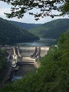
- Marèges Dam
- Dam at Bort-les-Orgues
- Barrage de l'Aigle (The Eagle Dam)
- Dam at Argentat
- Dam at Bergerac
- Dam at Chastang
- Dam at Mauzac
- Barrage de Tuilières
References
External links
| Wikimedia Commons has media related to Dordogne River. |
- The Dordogne at the Sandre database
- The Dordogne Valley in the Lot department (website in French)
- The Dordogne Valley UNESCO Biosphere Reserve (website in French)
| Authority control |
|
|---|