Domanivka Raion
Domanivka Raion (Ukrainian: Доманівський район) is located in Mykolaiv Oblast of Ukraine. Its administrative center is the urban-type settlement of Domanivka. Population: 25,555 (2015 est.)[1]
Domanivskyi Raion Доманівський район | |
|---|---|
Raion | |
 Flag  Coat of arms | |
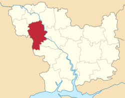 | |
| Coordinates: 47°38′41″N 30°59′24″E | |
| Country | |
| Region | Mykolaiv Oblast |
| Established | 1924 |
| Admin. center | Domanivka |
| Subdivisions | List
|
| Government | |
| • Governor | Taras Kushnir |
| Area | |
| • Total | 1,458 km2 (563 sq mi) |
| Population (2015) | |
| • Total | |
| Time zone | UTC+02:00 (EET) |
| • Summer (DST) | UTC+03:00 (EEST) |
| Postal index | 56400—56470 |
| Area code | +380 5152 |
History
In the 1920s, the current area of the district belonged to Odessa Governorate. In 1923, uyezds in Ukrainian Soviet Socialist Republic were abolished, and the governorates were divided into okruhas. In 1923, Kantakuzynka Raion with the administrative center in the selo of Kantakuzynka was established. It belonged to Pervomaisk Okruha. In 1925, the governorates were abolished, and okruhas were directly subordinated to Ukrainian SSR. On 3 February 1926, Katakuzynka Raion was renamed Domanivka Raion, and the center was moved to Domanivka.[2] In 1930, okruhas were abolished, and on 27 February 1932, Odessa Oblast was established, and Domanivka Raion was included into Odessa Oblast. In February 1954, Domanivka Raion was transferred to Mykolaiv Oblast.[3]
People
- Maxim Grabovenko (1923-1980)
References
- "Чисельність наявного населення України (Actual population of Ukraine)" (PDF) (in Ukrainian). State Statistics Service of Ukraine. Retrieved 1 July 2016.
- А. Айсфельд, ed. (2011). Немцы Николаевщины. 1918–1931 гг. Die Deutschen der Region Nikolaev. 1918–1931 (PDF). Mykolaiv: Илион. p. 17. ISBN 978-966-2056-51-8.
- "Районы Николаевской области" (in Russian). Николаевская область. Электронная историческая энциклопедия. Retrieved 6 March 2016.
| Raions | |||||
|---|---|---|---|---|---|
| Hromadas | |||||
| Cities |
| ||||
| |||||
| Authority control |
|
|---|