Divilacan
Divilacan, officially the Municipality of Divilacan (Ilocano: Ili ti Divilacan; Tagalog: Bayan ng Divilacan), is a 2nd class municipality in the province of Isabela, Philippines. According to the 2015 census, it has a population of 5,687 people.[3]
Divilacan | |
|---|---|
| Municipality of Divilacan | |
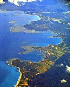
 Aerial view of Divilacan after Super Typhoon Megi (PAGASA name: Juan) | |
 Seal | |
 Map of Isabela with Divilacan highlighted | |
OpenStreetMap 
| |
.svg.png) Divilacan Location within the Philippines | |
| Coordinates: 17°20′N 122°18′E | |
| Country | |
| Region | Cagayan Valley (Region II) |
| Province | Isabela |
| District | 1st District of Isabela |
| Founded | 1969 |
| Barangays | 12 (see Barangays) |
| Government | |
| • Type | Sangguniang Bayan |
| • Mayor | Venturito C. Bulan |
| • Vice Mayor | Alfredo P. Custodio |
| • Congressman | Antonio T. Albano |
| • Electorate | 3,958 voters (2019) |
| Area | |
| • Total | 889.49 km2 (343.43 sq mi) |
| Population (2015 census)[3] | |
| • Total | 5,687 |
| • Density | 6.4/km2 (17/sq mi) |
| • Households | 1,260 |
| Economy | |
| • Income class | 2nd municipal income class |
| • Poverty incidence | 26.15% (2015)[4] |
| • Revenue (₱) | 139,505,953.22 (2016) |
| Time zone | UTC+8 (PST) |
| ZIP code | 3335 |
| PSGC | |
| IDD : area code | +63 (0)78 |
| Climate type | tropical rainforest climate |
| Native languages | Ibanag Ilocano Kasiguranin Paranan Tagalog |
Divilacan is one of the four (4) coastal municipalities of the province of Isabela facing the Philippine Sea to the east.
The town is bounded to the north by Maconacon, Tumauini to the west, Ilagan City to the southwest, Palanan to the south and the Philippine Sea to the east.
Etymology
Divilacan was derived from the native Dumagat compound word vilican, meaning “fish and shell.” The word di implies origin. Therefore, Divilacan literally means “where fish and shells abound.”
History
Divilacan was a former remote sitio of Barrio Antagan in the neighboring town of Tumauini. It became a separate municipality on June 21, 1969 by virtue of Republic Act No. 5776.
Barangays
Divilacan is politically subdivided into 12 barangays. [2]
- Dicambangan
- Dicaruyan
- Dicatian
- Bicobian
- Dilakit
- Dimapnat
- Dimapula (Poblacion)
- Dimasalansan
- Dipudo
- Dibulos
- Ditarum
- Sapinit
Demographics
| Year | Pop. | ±% p.a. |
|---|---|---|
| 1970 | 563 | — |
| 1975 | 1,207 | +16.53% |
| 1980 | 1,859 | +9.02% |
| 1990 | 2,479 | +2.92% |
| 1995 | 2,593 | +0.85% |
| 2000 | 3,413 | +6.07% |
| 2007 | 4,602 | +4.21% |
| 2015 | 5,687 | +2.68% |
| Source: Philippine Statistics Authority[3][5][6][7] | ||
In the 2015 census, the population of Divilacan was 5,687 people,[3] with a density of 6.4 inhabitants per square kilometre or 17 inhabitants per square mile.
Climate
| Climate data for Divilacan, Isabela | |||||||||||||
|---|---|---|---|---|---|---|---|---|---|---|---|---|---|
| Month | Jan | Feb | Mar | Apr | May | Jun | Jul | Aug | Sep | Oct | Nov | Dec | Year |
| Average high °C (°F) | 28.1 (82.6) |
29.5 (85.1) |
30.7 (87.3) |
32.4 (90.3) |
33.8 (92.8) |
33.8 (92.8) |
33.1 (91.6) |
32.8 (91.0) |
32.3 (90.1) |
31.3 (88.3) |
29.6 (85.3) |
28.3 (82.9) |
31.3 (88.3) |
| Average low °C (°F) | 19.9 (67.8) |
20.0 (68.0) |
21.9 (71.4) |
23.1 (73.6) |
24.1 (75.4) |
24.4 (75.9) |
24.3 (75.7) |
24.2 (75.6) |
23.9 (75.0) |
23.5 (74.3) |
22.1 (71.8) |
21.0 (69.8) |
22.7 (72.9) |
| Average precipitation mm (inches) | 31.2 (1.23) |
23 (0.9) |
27.7 (1.09) |
28.1 (1.11) |
113.5 (4.47) |
141.4 (5.57) |
176.4 (6.94) |
236.6 (9.31) |
224.9 (8.85) |
247.7 (9.75) |
222.9 (8.78) |
178 (7.0) |
1,651.4 (65) |
| Average rainy days | 10 | 6 | 5 | 5 | 13 | 12 | 15 | 15 | 15 | 17 | 16 | 15 | 144 |
| Source: Climate-Data.org[8] | |||||||||||||
Transportation
Divilacan is accessible via sea and air. The town is served by the Maconacon Airport in the neighboring town of Maconacon which connects this isolated town to Cauayan Airport, in Cauayan City.
The construction of an 82-kilometer Ilagan-Divilacan Road through the protected Sierra Madre mountains is on-going to open access to the coastal towns of Divilacan, Palanan and Maconacon. The approved budget contract of the project amounting to P1.5B, will pass through the foothills of the 359,486-hectare Northern Sierra Madre mountain ranges. The project will improve an old logging road used by a defunct logging company until the 1990s. It will start in Barangay Sindon Bayabo in Ilagan City and will end in Barangay Dicatian in this town. The project is started in March 2016 and is expected to be completed in 2021.[9]
References
- "Municipality". Quezon City, Philippines: Department of the Interior and Local Government. Retrieved 31 May 2013.
- "Province: Isabela". PSGC Interactive. Quezon City, Philippines: Philippine Statistics Authority. Retrieved 12 November 2016.
- Census of Population (2015). "Region II (Cagayan Valley)". Total Population by Province, City, Municipality and Barangay. PSA. Retrieved 20 June 2016.
- "PSA releases the 2015 Municipal and City Level Poverty Estimates". Quezon City, Philippines. Retrieved 1 January 2020.
- Census of Population and Housing (2010). "Region II (Cagayan Valley)". Total Population by Province, City, Municipality and Barangay. NSO. Retrieved 29 June 2016.
- Censuses of Population (1903–2007). "Region II (Cagayan Valley)". Table 1. Population Enumerated in Various Censuses by Province/Highly Urbanized City: 1903 to 2007. NSO.
- "Province of Isabela". Municipality Population Data. Local Water Utilities Administration Research Division. Retrieved 17 December 2016.
- "Divilacan, Isabela: Average Temperatures and Rainfall". Climate-Data.org. Retrieved 3 November 2015.
- "P2.3-B Isabela road link completed soon". The Manila Times. January 4, 2018. Retrieved 5 October 2018.
External links
| Wikimedia Commons has media related to Divilacan, Isabela. |
- Divilacan Profile at PhilAtlas.com
- Municipal Profile at the National Competitiveness Council of the Philippines
- Divilacan at the Isabela Government Website
- Local Governance Performance Management System
- Philippine Standard Geographic Code
- Philippine Census Information
Places adjacent to Divilacan | ||||||||||
|---|---|---|---|---|---|---|---|---|---|---|
| ||||||||||
Ilagan (capital) | |
| Municipalities |
|
| Component Cities | |
| Independent Component City |
|
| Barangays | See: List of barangays in Isabela |