Diefenbaker Management Area, Saskatoon
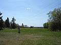
The Diefenbaker Management Area is an area of Saskatoon, to the west of the Exhibition subdivision. The area includes Diefenbaker Park and the Nutana Pioneer Cemetery. The park includes a medium-sized hill which is used for tobogganing and snowboarding, and the park itself is a frequently-used venue for picnics and public events and performances.
Diefenbaker Management Area | |
|---|---|
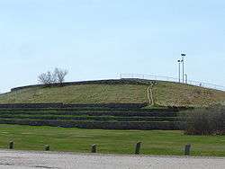 Diefenbaker Hill in Diefenbaker Park, prior to its 2018-19 redevelopment as Optimist Hill | |
| Coordinates: 52°05′48″N 106°41′18″W | |
| Country | |
| Province | |
| City | Saskatoon |
| Suburban Development Area | Nutana |
| Management Area | Diefenbaker Management Area |
| Government | |
| • Type | Municipal (Ward 7) |
| • Administrative body | Saskatoon City Council |
| • Councillor | Mairin Loewen |
| Population (2006) | |
| • Average Income | $ |
| Time zone | UTC-6 (UTC) |
| Website | Exhibition Community Association |
History
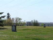
The Pioneer Cemetery received its first interment in 1884. On June 20, 1905 the Nutana Cemetery Co was awarded a special grant at SW Section 20 Township 36 Range 5 W of the 3rd Meridian. The Pioneer Cemetery, located west of the intersection of Ruth Street and St. Henry Avenue, was also called the Nutana Cemetery, and was the first municipal cemetery for the City of Saskatoon until 1910 when Woodlawn Cemetery became the city cemetery. The Pioneer Cemetery was declared a heritage site in 1982.[1]
Pioneer Cemetery. Saskatoon's first cemetery was established in 1884, a year after the community was established. It remained in use until 1909 and thereafter only for those who had already established plots. Among the gravestones still standing are those commemorating:
Robert Clark, whose death in 1884 from exhaustion while fighting a prairie fire was the first in the community:
Grace Fletcher, Saskatoon's first business woman and a campaigner for women's rights;
Edward Meeres, who lost his life in 1888 in a blizzard in what is now the centre of Nutana.
Members from many of Saskatoon's other notable pioneer families are buried here. In 1969 a number of graves were moved to Woodlawn Cemetery because of riverbank slumping. City of Saskatoon. Meewasin Valley Authority.— Image Pioneer Cemetery Plaque
 Pioneer Cemetery
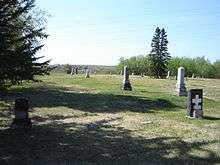 Pioneer Cemetery
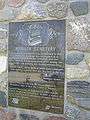 Pioneer Cemetery
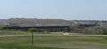
 Pioneer Cemetery
The southern portion of Diefenbaker Park has been disrupted by the development nearby of the Circle Drive freeway extension, which removed a strip of the park and now places formerly quiet areas right next to freeway traffic.
In 2018, a large portion of the park, including its hill—now called Optimist Hill—entered a period of reconstruction and redevelopment that saw it reconfigured into a $3 million recreation facility with a ski hill, seasonal chalet and terrain park, with a toboggan hill to follow in 2020. The facility opened to the public in February 2019.[2]
Events and festivals
Diefenbaker park is home to Saskatoon's organized events on Canada Day, consisting of official ceremonies, live entertainment, various activities and nighttime fireworks.[3]
Location
The Diefenbaker Management Area is located within the Nutana Suburban Development Area. It is bounded by the South Saskatchewan River to the west, St. Henry Avenue to the east, Ruth Street West to the north, and the city limits to the south. The only roads are St. Henry Avenue and the road looping through Diefenbaker Park.
References
- Nutana Cemetery, City of Saskatoon, archived from the original on 2010-11-08, retrieved 2011-02-09
- Matejka, Brittney (February 10, 2019). "Optimist Hill in Saskatoon opens to the public". Global News. Global News. Retrieved May 1, 2019.
- "Optimist Canada Day". Tourism Saskatoon. Retrieved 2012-12-10.
External links
| Wikimedia Commons has media related to Diefenbaker Management Area. |
- Saskatoon Neighbourhoods Word Search Puzzle
- City of Saskatoon · Departments · Community Services · Community ...
- City of Saskatoon · Departments · Community Services · City Planning · ZAM Maps
- Populace Spring 2006
- Sask Tourism We Are Many
- Sask Tourism We Are Many
Places adjacent to Diefenbaker Management Area, Saskatoon | ||||||||||
|---|---|---|---|---|---|---|---|---|---|---|
| ||||||||||