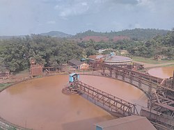
Dantewada district
Dantewada District, also known as Dantewara District or Dakshin Bastar District (South Bastar District), is a district in the Indian state of Chhattisgarh. Dantewada is the district headquarters. The district is part of Bastar Division. Until 1998, the Dantewada District was a tehsil of the larger Bastar District.
Dantewada district | |
|---|---|
District of Chhattisgarh | |
 | |
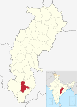 Location of Dantewada district in Chhattisgarh | |
| Country | India |
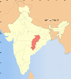
| State | Chhattisgarh |
| Division | Bastar |
| Headquarters | Dantewada |
| Tehsils | 4 |
| Government | |
| • Vidhan Sabha constituencies | 1 |
| Area | |
| • Total | 3,410.50 km2 (1,316.80 sq mi) |
| Population (2011) | |
| • Total | 2,83,479 |
| • Density | 83/km2 (220/sq mi) |
| Demographics | |
| • Literacy | 33 per cent |
| Time zone | UTC+05:30 (IST) |
| Website | dantewada |
As of 2011 it is the third least populous district of Chhattisgarh (out of 18), after Narayanpur and Bijapur.[1]
The present collector of Dantewada is Shri Deepak Soni.[2]
History
Before Indian Independence, the district was part of the princely state of Bastar. After Independence in 1947, Bastar's ruler acceded to the government of India, and the erstwhile state became part of Bastar District of Madhya Pradesh state. Bastar District was divided into the districts of Bastar, Dantewada, and Kanker in 1998. In 2000, Dantewada was one of the 16 Madhya Pradesh districts that constituted the new state of Chhattisgarh. Dantewada was bifurcated in 2007, resulting in a new district Bijapur district, Chhattisgarh with four tehsils: Bijapur, Bhairamgarh, Usoor and Bhopalpatnam. It was further bifurcated in 2012, resulting in another new district, Sukma, with three tehsils: Chhindgarh, Sukma and Konta.
Maoist rebellion
The district is currently a part of the Red Corridor.[3] Over the last year, more than 350 people have been killed and 50,000 moved into camps in the Dantewada district, as a result of a Maoist uprising.
In April 2010, the Maoist rebels killed at least 75 Indian soldiers in a series of attacks on security convoys in Dantewada.[4] In May 2010, the Naxals targeted the Special Police Officers traveling in a civilian bus, killing around 31,[5] to 44,[6] including several Special Police Officers and civilians.[7]
Education
Dantewada is the worst affected Maoist region, but the students still managed to perform well in their high-school board examinations. In 2017, their pass percentage crossed 80 for the first time, making Dantewada the best performing district on the board exam.[8]
The average literacy rate of Dantewada (Dantewara) district is 33.21 percent.
Dantewada received the Prime Minister's award for converting Palnar into a cashless village.[9] After the November 8 demonetisation of high-value notes, Dantewada district collector Saurabh Kumar and his team managed to procure fibre and bandwidth from Essar Steel under its corporate social responsibility to create a free wi-fi zone of two and half square km area to kick-start digital payments in the village market that houses 14 shops.[10] This village is now connected digitally although it has no cellular connectivity even now.
Educational Institutes
1- Government Danteshwari PG College Dantewada
http://www.pgcollegedantewada.com
2. College of Agriculture, Chitalanka, Dantewada
3. Kendriya Vidyalaya (KV), Dantewada
http://www.kvdantewada.com/home.php
4.Jawahar Navodaya Vidyalaya, Barsoor, Dantewada
5. Govt Model Higher Secondary School, Dantewada
6. NMDC Polytechnic College Dantewada
Geography
Dantewada District has an area of 3,410.50 km².
Administrative divisions
Dantewada district is divided into four tehsils, each of which is also a "development block". It is further divided into 114 gram panchayats.[11] The four tehsils are:[12]
- Dantewada Tehsil with 31 gram panchayats[13]
- Geedam Tehsil with 34 gram panchayats
- Katekalyan Tehsil with 23 gram panchayats
- Kuwakonda Tehsil with 26 gram panchayats
Demographics
According to the 2011 census Dantewada district has a population of 533,638,[1] roughly equal to the half of the nation of Cape Verde.[14] This gives it a ranking of 540th in India (out of a total of 640).[1] The district has a population density of 45 inhabitants per square kilometre (120/sq mi) .[1] Its population growth rate over the decade 2001-2011 was 15.56%.[1] Dantewada has a sex ratio of 1016 females for every 1000 males,[1] and a literacy rate of 42.27%.[1]
At the time of the 2011 Census of India, 64.16% of the population in the district spoke Gondi, 14.88% Halbi, 11.27% Chhattisgarhi, 3.81% Duruwa, 1.52% Odia, 1.49% Telugu and 1.44% Bengali as their first language.[15]
The district has a population of 247,029 (2011 census), of which 173,714 are tribal peoples (adivasis). The district is divided into four tehsils, Dantewada, Gidam, Kuwakonda and Katekalyan.
References
- "District Census 2011". Census2011.co.in. 2011. Retrieved 2011-09-30.
- http://dantewada.gov.in
- "83 districts under the Security Related Expenditure Scheme". IntelliBriefs. 2009-12-11. Retrieved 2011-09-17.
- Scores of Indian soldiers killed in Maoist ambushes. BBC. 6 April 2010.
- http://www.ndtv.com/news/india/dantewada-bus-blast-toll-30-pm-to-review-naxal-strategy-26185.php?u=1439
- "Talks with Maoists if they suspend violence: Chidambaram". The Times Of India. 18 May 2010.
- "Naxals blow up bus near Dantewada, 50 feared killed". NDTV. 17 May 2010.
- "Maoist-hit Dantewada outperforms urban districts in boards". New Indian Express. 30 April 2017. Retrieved 30 April 2017.
- "Dantewada district gets Prime Minister's award for converting Palnar into a cashless village". The Economic Times. Retrieved 29 December 2017.
- "Remote Chhattisgarh village gets PM award for going cashless". India Today. Retrieved 29 December 2017.
- "Reports of National Panchayat Directory: Districts of Chhattisgarh". Ministry of Panchayati Raj, Government of India. Archived from the original on 2011-10-11.
- "Reports of National Panchayat Directory: Blocks of Chhattisgarh". Ministry of Panchayati Raj, Government of India. Archived from the original on 2011-10-11.
- "Reports of National Panchayat Directory: Village Panchayat Names of Dantewada, Dantewada, Chhattisgarh". Ministry of Panchayati Raj, Government of India. Archived from the original on 2011-11-12. Retrieved 2013-02-24.
- US Directorate of Intelligence. "Country Comparison:Population". Retrieved 2011-10-01.
Cape Verde 516,100 July 2011 est.
- 2011 Census of India, Population By Mother Tongue
External links
Places adjacent to Dantewada district | |
|---|---|
Capital: Raipur (Current) Naya Raipur (Future) | ||
| Governance |
|  |
| Topics | ||
| Divisions |
| |
| Districts | ||
| Cities | ||
| ||
| Authority control |
|
|---|