Dandenong Creek
The Dandenong Creek (Aboriginal Bunwurrung: Narra Narrawong[1] or Dandinnong[2]) is an urban creek[3] of the Port Phillip catchment, located in the eastern and south-eastern Greater Melbourne region of the Australian state of Victoria.
| Dandenong Dand-y-non, Tanjenong[1] | |
|---|---|
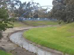 Dandenong Creek channeled as an urban stream in Dandenong | |
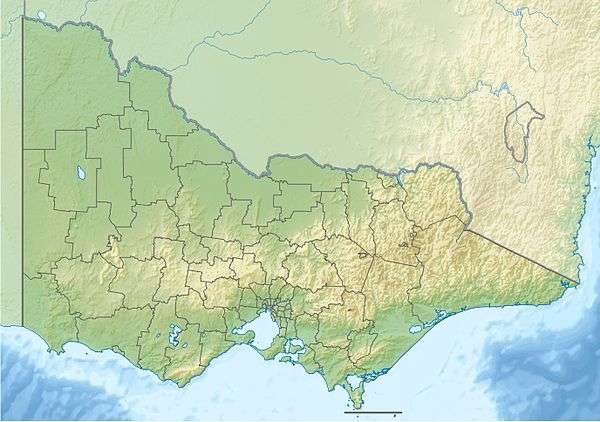 Location of the Dandenong Creek mouth in Victoria | |
| Etymology | Aboriginal Bunwurrung: "high" or "lofty"[1] |
| Native name | Narra Narrawong,[1] Dandinnong[2] |
| Location | |
| Country | Australia |
| State | Victoria |
| Region | South East Coastal Plain (IBRA), Greater Melbourne |
| Local government area | City of Monash |
| Physical characteristics | |
| Source | Dandenong Ranges |
| 2nd source | Bungalook Creek |
| • location | near Heathmont |
| • coordinates | 37°50′8″S 145°15′25″E |
| • elevation | 556 m (1,824 ft) |
| Mouth | confluence with the Eumemmerring Creek to form the Patterson River |
• location | southwest of Bangholme |
• coordinates | 38°2′37″S 145°10′29″E |
• elevation | 6 m (20 ft) |
| Length | 53 km (33 mi) |
| Basin features | |
| River system | Port Phillip catchment |
| Tributaries | |
| • left | Corhanwarrabul Creek, Blind Creek, Old Joes Creek, Dobsons Creek |
| • right | Mordialloc Creek, Mile Creek, Heatherdale Creek, Bungalook Creek, Little Bungalook Creek |
| [3][4] | |
Location and features
Dandenong Creek has its headwaters in the Dandenong Ranges near Olinda, within the Dandenong Ranges National Park and is sourced by downstream flows from the Bungalook Creek. The creek flows generally south by southwest, joined by the Corhanwarrabul Creek, before reaching its confluence with the Eumemmerring Creek to form the man-made Patterson River southwest of Bangholme. The creek descends approximately 550 metres (1,800 ft) over its course of 53 kilometres (33 mi).[1]
The health of the creek in these urban areas ranges from moderate to very poor and has been the focus of a number of clean-up campaigns in recent years.[5]
The creek is also the home of one of the largest remaining populations of Yarra Gum.[6]
A bike path known as the Dandenong Creek Trail runs alongside for a significant distance.
An industrial wastewater stream known as Old Joes Creek flows into Dandenong Creek, with its confluence in Bayswater.[7] This drain runs underground for much of its course, running in a westerly direction and servicing several industrial estates in the catchment of Dandenong Creek.[8] The tributary is commonly polluted with heavy metals, and authorities have made several attempts to prevent pollution which spreads downstream into Dandenong Creek.[9][10]
Etymology
The traditional custodians of the land surrounding what is now known as the Dandenong Creek were the indigenous Bunurong people of the Kulin nation who referred to the creek as Narra Narrawong; while others gave the creek the name Dandenong, sometimes spelled as Dand-y-non or Tanjenong by early settlers, believed to mean "high" or "lofty".[1]
History
The first European to see the creek near its source was in 1839 and is believed to be Daniel Bunce, a botanist.[1]
Creek crossings
The list below notes current bridges that cross over the Dandenong Creek. Some are road and rail bridges, whilst others are pedestrian and equestrian crossings.
Patterson River to Dandenong Valley Parklands
| Crossing | Image | Coordinates | Built | Suburb | Description |
|---|---|---|---|---|---|
| Old Perry Road | Bangholme | Ruins of old Perry Road bridge over Dandenong Creek | |||
| Perry Road | |||||
| EastLink | 2008 | Dandenong South | EastLink | ||
| Greens Road | |||||
| Dandenong Bypass | 2008 | ||||
| EastLink Trail | 2008 | Dandenong | |||
| Hammond Road | |||||
| Gippsland Railway bridge | Bridge carrying the Gippsland line over the creek | ||||
| Lonsdale Street pedestrian bridge | Footbridge over the creek along Lonsdale Street | ||||
| Lonsdale Street | The crossing of the Princes Highway, locally named Lonsdale Street | ||||
| Dandenong Creek Trail | |||||
| Dandenong Park footbridge | | ||||
| McCrae Street | |||||
| Dandenong Workers Social Club footbridge | Footbridge between the Dandenong Workers Social Club and their golf course | ||||
| Kidds Road | |||||
| Heatherton Road | Dandenong North | ||||
| Monash Freeway | |||||
| Brady Road | |||||
| Stud Road | |||||
| Police Road Retarding Basin | Mulgrave | There is a path along the basin wall, enabling pedestrian crossing of the creek | |||
| EastLink | 2008 | ||||
| Wellington Road | Rowville |
Dandenong Valley Parklands
| Crossing | Image | Coordinates | Built | Suburb | Description |
|---|---|---|---|---|---|
| Dandenong Valley wetland trail | 2010 | Scoresby | Shared path over the creek | ||
| Ferntree Gully Road | |||||
| EastLink Trail | 2008 | ||||
| Dandenong Creek Trail | |||||
| Patterson's Bridge | Wantirna South | Part of Dandenong Creek Trail | |||
| High Street Road footbridge | Footbridge linking Napier Park with Nortons Park | ||||
| High Street | |||||
| Burwood Highway | Vermont South | ||||
| Dandenong Creek Trail |
Dandenong Valley Parklands to Mount Dandenong
| Crossing | Image | Coordinates | Built | Suburb | Description |
|---|---|---|---|---|---|
| Boronia Road | Vermont | ||||
| EastLink Trail | Section of the EastLink Trail linking Winton Wetlands with Campbells Croft Reserve | ||||
| EastLink | 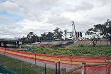 | 2008 | Ringwood | ||
| Wantirna Road | |||||
| Marlborough Road footbridge | Heathmont | Footbridge at the end of Marlborough Road | |||
| H.E. Parker Reserve footbridge | Footbridge connecting the Dandenong Creek Trail with H.E. Parker Reserve | ||||
| Belgrave railway line | Bayswater North | ||||
| Tarralla Creek Trail | |||||
| Bayswater Road | |||||
| Dorset Road | |||||
| Colchester Road | Kilsyth South | ||||
| Liverpool Road Retarding Basin wall | Boronia | Path along basin wall provides crossing over the creek | |||
| Liverpool Road Retarding Basin footbridge | Footbridge inside the retarding basin provides crossing over the creek | ||||
| Liverpool Road | The Basin | ||||
| Dobson Lane | Dobson Lane | ||||
| Pavitt Lane | Kilsyth | ||||
| Sheffield Road | |||||
| Edgar Track | Mount Dandenong | ||||
| Doongalla Forest access road | |||||
| Dandenong Creek Track | Olinda |
References
- "Snapshot of Dandenong Creek" (PDF). Fact sheet. Melbourne Water. Archived from the original (PDF) on 13 April 2014. Retrieved 11 April 2014.
- "Dandenong Creek: 13888: Historical information". Vicnames. Government of Victoria. 12 August 2011. Archived from the original on 13 April 2014. Retrieved 11 April 2014.
- "Dandenong Creek: 13888". Vicnames. Government of Victoria. 2 May 1966. Archived from the original on 11 April 2014. Retrieved 11 April 2014.
- "Map of Dandenong Creek, VIC". Bonzle Digital Atlas of Australia. Retrieved 11 April 2014.
- "Dandenong Creek". Rivers and Creeks. Melbourne Water. Archived from the original on 5 September 2007. Retrieved 4 September 2007.
- "Flora and Fauna: Significant Plant Species". Archived from the original on 28 August 2007. Retrieved 4 September 2007.
- "Old Joes Creek gets a makeover". BehaviourWorks Australia. Monash Sustainable Development Institute. 2015. Retrieved 19 July 2019.
- Frame, Joanna; Coleman, Rhys; Moore, Trivess (August 2005). "Waterway assessment in the Dandenong Valley Catchment: Water quality in Upper Dandenong Creek and associated tributaries". Melbourne Water Corporation. Cite journal requires
|journal=(help) - "EPA fines Bayswater company over $7500". Environment Protection Authority Victoria. 26 February 2016. Retrieved 19 July 2019.
- "Pollution Detection and Prevention". Melbourne Water. Retrieved 19 July 2019.
External links
- Returning Dandenong Creek project
- First Friends of Dandenong Creek website
- "Info sourced on place names in the area". Knox Historical Society. Archived from the original on 17 March 2012.
Waterways of the Greater Melbourne catchment, Victoria, Australia | |
|---|---|
| Ocean inlets, harbours and bays | |
| Rivers | |
| Creeks |
|
| Lagoons and lakes | |
| Adjoining rivers and bays | |
| |
| Port Phillip sub-catchment |
|
|---|---|
| Western Port sub-catchment | |
| |