County of Dargo
The County of Dargo is one of the 37 counties of Victoria which are part of the cadastral divisions of Australia, used for land titles. It is located in Gippsland, between the Mitchell River in the west and the Tambo River in the east. Lake King is on the southern edge. It was gazetted in 1871. Earlier maps show the area as being part of a proposed County of Abinger.
| Dargo Victoria | |||||||||||||||
|---|---|---|---|---|---|---|---|---|---|---|---|---|---|---|---|
 Location in Victoria | |||||||||||||||
| Established | 24 February 1871 | ||||||||||||||
| Area | 5,272 km2 (2,035.5 sq mi) | ||||||||||||||
| |||||||||||||||
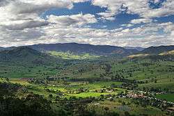
Swifts Creek is located near the eastern edge of the county, along the Tambo River
Parishes
Parishes include:
- Angora, Victoria
- Barroworn, Victoria
- Bemboka, Victoria
- Binnican, Victoria
- Birregun, Victoria
- Boonderoot, Victoria
- Broadlands, Victoria
- Bulgaback, Victoria
- Bullumwaal, Victoria
- Bumberrah, Victoria
- Caarneek, Victoria
- Carneek, Victoria
- Cooma, Victoria
- Cowa, Victoria
- Dargo, Victoria
- Doodwuk, Victoria
- Graham, Victoria
- Guttamurra, Victoria
- Jirnkee, Victoria
- Kalk Kalk, Victoria
- Kianeek, Victoria
- Koomberar, Victoria
- Kooroon, Victoria
- Moonip, Victoria
- Morekana, Victoria
- Mullawye, Victoria
- Nungatta, Victoria
- Nurong, Victoria
- Onyim, Victoria
- Quag-Munjie, Victoria
- Sarsfield, Victoria
- Tabberabbera, Victoria
- Tambo, Victoria
- Tarkeeth, Victoria
- Terlite-Munjie, Victoria
- Thornley, Victoria
- Tongio-Munjie West, Victoria
- Tyirra, Victoria
- Wamba, Victoria
- Wentworth, Victoria
- Wongungarra, Victoria
- Wuk Wuk, Victoria
- Wy-Yung, Victoria
- Yambulla, Victoria
- Yertoo, Victoria
- Yonduk, Victoria
References
- Vicnames, place name details
- Research aids, Victoria 1910
- Map of the counties of Benambra, Tambo, Croajingolong and Dargo in Victoria showing county boundaries, parish boundaries, main roads, telegraph lines and railways. 1886, National Library of Australia
This article is issued from Wikipedia. The text is licensed under Creative Commons - Attribution - Sharealike. Additional terms may apply for the media files.