Conghua District
Conghua District, alternately romanized as Tsungfa,[lower-alpha 1] is one of 11 urban districts and the northernmost district of the prefecture-level city of Guangzhou, the capital of Guangdong Province, China. Conghua connects the Pearl River Delta with the mountainous area of northern Guangdong.[4] Within China, it is known for its hot springs[5] and lychees.[6] It covers an area of 1,974.15 km2 (762.22 sq mi), with a population of 543.377 in 2006. Its GDP was RMB10.369 billion (US$2,360 per person).
Conghua 从化区 Tsungfa | |
|---|---|
District | |
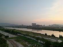 Liuxi Riverfront Park in Jiekou Subdistrict | |
| |
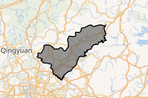
 Conghua in Guangzhou | |
| Coordinates: 23°39′N 113°40′E | |
| Country | People's Republic of China |
| Province | Guangdong |
| Sub-provincial city | Guangzhou |
| Area | |
| • Total | 1,974.15 km2 (762.22 sq mi) |
| Population (2006) | |
| • Total | 543,377 |
| • Density | 280/km2 (710/sq mi) |
| Time zone | UTC+8 (China Standard) |
| Postal code | 510900 |
| Area code(s) | 020 |
| Website | www |
| Conghua | |||||||||||||||||
|---|---|---|---|---|---|---|---|---|---|---|---|---|---|---|---|---|---|
| Simplified Chinese | 从化 | ||||||||||||||||
| Traditional Chinese | 從化 | ||||||||||||||||
| Guangdong Romanization | Cung4-fa3 | ||||||||||||||||
| Hanyu Pinyin | Cónghuà | ||||||||||||||||
| Postal | Tsungfa | ||||||||||||||||
| Literal meaning | From Change | ||||||||||||||||
| |||||||||||||||||
History
Under the Qing, the area was known as Conghua County. It was subsequently upgraded to county-level city status and then, on 12 February 2014, to an urban district of Guangzhou.[7]
Administrative divisions
| Name | Chinese (S) | Hanyu Pinyin | Canton Romanization | Population (2010)[8] | Area (km2) |
|---|---|---|---|---|---|
| Jiekou Subdistrict | 街口街道 | Jiēkǒu Jiēdào | gai1 heo2 gai1 dou6 | 96,846 | 21.84 |
| Chengjiao Subdistrict | 城郊街道 | Chéngjiāo Jiēdào | séng4 gao1 gai1 dou6 | 79,085 | 160.00 |
| Jiangbu Subdistrict | 江埔街道 | Jiāngbù Jiēdào | gong1 bou3 gai1 dou6 | 95,843 | 127.00 |
| Wenquan town | 温泉镇 | Wēnquán Zhèn | wen1 qun4 zen3 | 55,194 | 210.90 |
| Liangkou town | 良口镇 | Liángkǒu Zhèn | lêng4 heo2 zen3 | 32,829 | 530.60 |
| Lütian town | 吕田镇 | Lǚtián Zhèn | lêu5 tin4 zen3 | 23,430 | 393.00 |
| Taiping town | 太平镇 | Tàipíng Zhèn | tai3 ping4 zen3 | 94,369 | 210.32 |
| Aotou town | 鳌头镇 | Áotóu Zhèn | ngou4 teo4 zen3 | 111,308 | 410.00 |
Climate
| Climate data for Conghua (1981−2010) | |||||||||||||
|---|---|---|---|---|---|---|---|---|---|---|---|---|---|
| Month | Jan | Feb | Mar | Apr | May | Jun | Jul | Aug | Sep | Oct | Nov | Dec | Year |
| Record high °C (°F) | 28.6 (83.5) |
30.3 (86.5) |
33.0 (91.4) |
34.0 (93.2) |
35.4 (95.7) |
37.9 (100.2) |
39.0 (102.2) |
37.7 (99.9) |
37.6 (99.7) |
36.7 (98.1) |
34.1 (93.4) |
29.8 (85.6) |
39.0 (102.2) |
| Average high °C (°F) | 18.4 (65.1) |
19.0 (66.2) |
21.5 (70.7) |
25.8 (78.4) |
29.6 (85.3) |
31.6 (88.9) |
33.3 (91.9) |
33.4 (92.1) |
31.9 (89.4) |
29.4 (84.9) |
25.0 (77.0) |
20.7 (69.3) |
26.6 (79.9) |
| Daily mean °C (°F) | 12.8 (55.0) |
14.4 (57.9) |
17.3 (63.1) |
22.0 (71.6) |
25.3 (77.5) |
27.4 (81.3) |
28.6 (83.5) |
28.4 (83.1) |
26.8 (80.2) |
23.6 (74.5) |
18.7 (65.7) |
14.1 (57.4) |
21.6 (70.9) |
| Average low °C (°F) | 9.0 (48.2) |
11.2 (52.2) |
14.2 (57.6) |
19.0 (66.2) |
22.1 (71.8) |
24.3 (75.7) |
25.1 (77.2) |
25.0 (77.0) |
23.2 (73.8) |
19.5 (67.1) |
14.3 (57.7) |
9.6 (49.3) |
18.0 (64.5) |
| Record low °C (°F) | −2.9 (26.8) |
0.0 (32.0) |
1.3 (34.3) |
8.3 (46.9) |
12.9 (55.2) |
17.0 (62.6) |
20.1 (68.2) |
22.2 (72.0) |
15.5 (59.9) |
8.5 (47.3) |
1.5 (34.7) |
−1.6 (29.1) |
−2.9 (26.8) |
| Average precipitation mm (inches) | 54.2 (2.13) |
84.7 (3.33) |
135.5 (5.33) |
238.3 (9.38) |
315.3 (12.41) |
364.2 (14.34) |
237.8 (9.36) |
217.8 (8.57) |
147.0 (5.79) |
47.9 (1.89) |
39.0 (1.54) |
35.2 (1.39) |
1,916.9 (75.46) |
| Average relative humidity (%) | 73 | 79 | 82 | 83 | 82 | 83 | 80 | 81 | 79 | 74 | 71 | 70 | 78 |
| Source: China Meteorological Data Service Center | |||||||||||||
Notes
References
Citations
- Encyclopædia Britannica, 9th ed. (1878), Vol. V, "China".
- Encyclopædia Britannica, 11th ed. (1911), Vol. XV, "Kwang-tung".
- Gutzlaff (1838), p. 564.
- "2011年统计用区划代码和城乡划分代码:从化市" (in Simplified Chinese). National Bureau of Statistics of the People's Republic of China. Retrieved 2012-11-17.
- Conghua Hot Springs
- Lychee
- "黄埔萝岗合二为一 增城从化撤市改区". Nandu(南都网). Archived from the original on 22 February 2014. Retrieved 13 February 2014.
- shi, Guo wu yuan ren kou pu cha ban gong; council, Guo jia tong ji ju ren kou he jiu ye tong ji si bian = Tabulation on the 2010 population census of the people's republic of China by township / compiled by Population census office under the state; population, Department of; statistics, employment statistics national bureau of (2012). Zhongguo 2010 nian ren kou pu cha fen xiang, zhen, jie dao zi liao (Di 1 ban. ed.). Beijing Shi: Zhongguo tong ji chu ban she. ISBN 978-7-5037-6660-2.
Bibliography
External links
- Official website of Guangdong Province
- Official website of Conghua Government
- Guangzhou International Website - English version
- Lychee Festival

.JPG)
Guangzhou (capital) | |||||||||||||||||||||||||||||||||||||||||||||||||||||||||||||||||||||
| Sub-provincial cities |
| ||||||||||||||||||||||||||||||||||||||||||||||||||||||||||||||||||||
| Prefecture-level cities |
| ||||||||||||||||||||||||||||||||||||||||||||||||||||||||||||||||||||
| |||||||||||||||||||||||||||||||||||||||||||||||||||||||||||||||||||||
Pearl River Delta Metropolitan Region (Guangdong-Hong Kong-Macau Greater Bay Area) | ||
|---|---|---|
| Guangdong Province |  | |
| Special administrative regions | ||
| Authority control |
|
|---|
This article is issued from Wikipedia. The text is licensed under Creative Commons - Attribution - Sharealike. Additional terms may apply for the media files.