Clermont, Georgia
Clermont is a town in Hall County, Georgia, United States. The population was 875 at the 2010 census.[5] It is part of the Gainesville, GA Metropolitan Statistical Area.
Clermont, Georgia | |
|---|---|
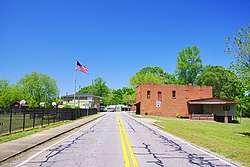 Main Street (SR 284) | |
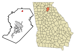 Location in Hall County and the state of Georgia | |
| Coordinates: 34°28′38″N 83°46′27″W | |
| Country | United States |
| State | Georgia |
| County | Hall |
| Area | |
| • Total | 2.97 sq mi (7.69 km2) |
| • Land | 2.95 sq mi (7.65 km2) |
| • Water | 0.02 sq mi (0.04 km2) |
| Elevation | 1,401 ft (427 m) |
| Population (2010) | |
| • Total | 875 |
| • Estimate (2019)[2] | 1,039 |
| • Density | 351.85/sq mi (135.87/km2) |
| Time zone | UTC-5 (Eastern (EST)) |
| • Summer (DST) | UTC-4 (EDT) |
| ZIP code | 30527 |
| Area code(s) | 770 |
| FIPS code | 13-16796[3] |
| GNIS feature ID | 0331416[4] |
| Website | www |
History
An early variant name was "Dip".[6] A post office called Dip was established in 1892, and the name was changed to Clermont in 1905.[7] The Georgia General Assembly incorporated the place in 1913 as the "Town of Clermont", with municipal corporate limits extending in a one-mile radius from the intersection of King and Main streets.[8]
Geography
Clermont is located in northern Hall County at 34°28′38″N 83°46′27″W (34.477171, -83.774044).[9] U.S. Route 129 passes through the town, leading north 9 miles (14 km) to Cleveland and south 15 miles (24 km) to Gainesville, the county seat. Georgia State Route 283 and Georgia State Route 284 intersect in Clermont.
According to the United States Census Bureau, the town has a total area of 3.0 square miles (7.7 km2), of which 0.02 square miles (0.04 km2), or 0.46%, are water.[5]
Demographics
| Historical population | |||
|---|---|---|---|
| Census | Pop. | %± | |
| 1920 | 332 | — | |
| 1930 | 328 | −1.2% | |
| 1940 | 297 | −9.5% | |
| 1950 | 323 | 8.8% | |
| 1960 | 268 | −17.0% | |
| 1970 | 290 | 8.2% | |
| 1980 | 300 | 3.4% | |
| 1990 | 402 | 34.0% | |
| 2000 | 419 | 4.2% | |
| 2010 | 875 | 108.8% | |
| Est. 2019 | 1,039 | [2] | 18.7% |
| U.S. Decennial Census[10] | |||
As of the census[3] of 2000, there were 419 people, 161 households, and 124 families residing in the town. The population density was 434.5 people per square mile (168.5/km2). There were 170 housing units at an average density of 176.3 per square mile (68.4/km2). The racial makeup of the town was 96.18% White, 0.95% African American, 1.43% Native American, 0.24% Asian, and 1.19% from two or more races. Hispanic or Latino of any race were 0.48% of the population.
There were 161 households, out of which 34.8% had children under the age of 18 living with them, 63.4% were married couples living together, 11.2% had a female householder with no husband present, and 22.4% were non-families. 18.0% of all households were made up of individuals, and 6.2% had someone living alone who was 65 years of age or older. The average household size was 2.60 and the average family size was 2.94.
In the town, the population was spread out, with 25.5% under the age of 18, 8.8% from 18 to 24, 31.0% from 25 to 44, 22.7% from 45 to 64, and 11.9% who were 65 years of age or older. The median age was 35 years. For every 100 females, there were 93.1 males. For every 100 females age 18 and over, there were 97.5 males.
The median income for a household in the town was $43,333, and the median income for a family was $46,000. Males had a median income of $31,875 versus $25,000 for females. The per capita income for the town was $15,558. About 4.8% of families and 5.6% of the population were below the poverty line, including 2.5% of those under age 18 and 1.9% of those age 65 or over.
References
- "2019 U.S. Gazetteer Files". United States Census Bureau. Retrieved July 9, 2020.
- "Population and Housing Unit Estimates". United States Census Bureau. May 24, 2020. Retrieved May 27, 2020.
- "U.S. Census website". United States Census Bureau. Retrieved 2008-01-31.
- "US Board on Geographic Names". United States Geological Survey. 2007-10-25. Retrieved 2008-01-31.
- "Geographic Identifiers: 2010 Demographic Profile Data (G001): Clermont town, Georgia". American Factfinder. U.S. Census Bureau. Retrieved May 17, 2017.
- Krakow, Kenneth K. (1975). Georgia Place-Names: Their History and Origins (PDF). Macon, GA: Winship Press. p. 45. ISBN 0-915430-00-2.
- "Post Offices". Jim Forte Postal History. Retrieved 8 April 2018.
- Acts Passed by the General Assembly of Georgia. J. Johnston. 1913. p. 674.
- "US Gazetteer files: 2010, 2000, and 1990". United States Census Bureau. 2011-02-12. Retrieved 2011-04-23.
- "Census of Population and Housing". Census.gov. Retrieved June 4, 2015.
External links
| Wikimedia Commons has media related to Clermont, Georgia. |
Municipalities and communities of Hall County, Georgia, United States | ||
|---|---|---|
| City |  Map of Georgia highlighting Hall County | |
| Towns | ||
| Unincorporated communities | ||
| Footnotes | ‡This populated place also has portions in an adjacent county or counties | |