Claveria, Cagayan
Claveria, officially the Municipality of Claveria (Ibanag: Ili nat Claveria; Ilocano: Ili ti Claveria; Tagalog: Bayan ng Claveria), is a 3rd class municipality in the province of Cagayan, Philippines. According to the 2015 census, it has a population of 29,921 people.[3] It was located directly south of Taiwan via Bashi Channel to Luzon Strait and north of Luzon Island.
Claveria | |
|---|---|
| Municipality of Claveria | |
 | |
 Seal | |
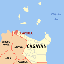 Map of Cagayan with Claveria highlighted | |
OpenStreetMap 
| |
.svg.png) Claveria Location within the Philippines | |
| Coordinates: 18°36′N 121°05′E | |
| Country | |
| Region | Cagayan Valley (Region II) |
| Province | Cagayan |
| District | 2nd District |
| Barangays | 41 (see Barangays) |
| Government | |
| • Type | Sangguniang Bayan |
| • Mayor | Celia T. Layus |
| • Vice Mayor | Solferino A. Agra Jr. |
| • Congressman | Samantha Louise V. Alfonso |
| • Electorate | 18,247 voters (2016) |
| Area | |
| • Total | 194.80 km2 (75.21 sq mi) |
| Population (2015 census)[3] | |
| • Total | 29,921 |
| • Density | 150/km2 (400/sq mi) |
| • Households | 6,956 |
| Economy | |
| • Income class | 3rd municipal income class |
| • Poverty incidence | 9.42% (2015)[4] |
| • Revenue (₱) | 104,014,882.10 (2016) |
| Time zone | UTC+8 (PST) |
| ZIP code | 3519 |
| PSGC | |
| IDD : area code | +63 (0)78 |
| Climate type | tropical monsoon climate |
| Native languages | Ilocano Ibanag Isnag Tagalog |
| Website | www |
Barangays
Claveria is politically subdivided into 41 barangays.
- Alimoan
- Bacsay Cataraoan Norte
- Bacsay Cataraoan Sur
- Bacsay Mapulapula
- Bilibigao
- Buenavista
- Cadcadir East (former brgy of Santa Praxedes)
- Cadcadir West (former brgy of Santa Praxedes)
- Camalagaoan/D. Leaño
- Capannikian
- Centro I (Poblacion)
- Centro II (Poblacion)
- Centro III (Poblacion)
- Centro IV (Nangasangan)
- Centro V (Mina)
- Centro VI (Minanga)
- Centro VII (Malasin East)
- Centro VIII (Malasin West)
- Culao
- Dibalio
- Kilkiling (former brgy of Santa Praxedes)
- Lablabig (former brgy of Santa Praxedes)
- Luzon
- Mabnang (former brgy of Santa Praxedes)
- Magdalena
- Malilitao
- Nagsabaran
- Pata East
- Pata West
- Pinas
- Santiago
- San Antonio (Sayad/Bimmokel)
- San Isidro
- San Vicente
- Santa Maria
- Santo Niño (Barbarnis)
- Santo Tomas
- Tabbugan
- Taggat Norte
- Taggat Sur
- Union (former brgy of Santa Praxedes)
Demographics
| Year | Pop. | ±% p.a. |
|---|---|---|
| 1903 | 5,472 | — |
| 1918 | 8,516 | +2.99% |
| 1939 | 11,989 | +1.64% |
| 1948 | 12,703 | +0.64% |
| 1960 | 17,025 | +2.47% |
| 1970 | 22,614 | +2.88% |
| 1975 | 23,126 | +0.45% |
| 1980 | 24,509 | +1.17% |
| 1990 | 24,145 | −0.15% |
| 1995 | 25,363 | +0.93% |
| 2000 | 29,277 | +3.12% |
| 2007 | 30,275 | +0.46% |
| 2015 | 29,921 | −0.15% |
| Source: Philippine Statistics Authority[3][5][6][7] | ||
In the 2015 census, the population of Claveria, Cagayan, was 29,921 people,[3] with a density of 150 inhabitants per square kilometre or 390 inhabitants per square mile.
Climate
| Climate data for Claveria, Cagayan | |||||||||||||
|---|---|---|---|---|---|---|---|---|---|---|---|---|---|
| Month | Jan | Feb | Mar | Apr | May | Jun | Jul | Aug | Sep | Oct | Nov | Dec | Year |
| Average high °C (°F) | 26 (79) |
28 (82) |
30 (86) |
32 (90) |
31 (88) |
31 (88) |
30 (86) |
30 (86) |
30 (86) |
29 (84) |
28 (82) |
26 (79) |
29 (85) |
| Average low °C (°F) | 20 (68) |
20 (68) |
21 (70) |
23 (73) |
25 (77) |
25 (77) |
25 (77) |
25 (77) |
24 (75) |
23 (73) |
23 (73) |
21 (70) |
23 (73) |
| Average precipitation mm (inches) | 55 (2.2) |
41 (1.6) |
37 (1.5) |
41 (1.6) |
184 (7.2) |
215 (8.5) |
261 (10.3) |
256 (10.1) |
245 (9.6) |
216 (8.5) |
142 (5.6) |
129 (5.1) |
1,822 (71.8) |
| Average rainy days | 14.1 | 11.1 | 11.8 | 12.5 | 21.8 | 25.2 | 25.5 | 24.9 | 23.8 | 18.2 | 16.4 | 17.0 | 222.3 |
| Source: Meteoblue (modeled/calculated data, not measured locally) [8] | |||||||||||||
References
- "Municipality". Quezon City, Philippines: Department of the Interior and Local Government. Retrieved 31 May 2013.
- "Province: Cagayan". PSGC Interactive. Quezon City, Philippines: Philippine Statistics Authority. Retrieved 12 November 2016.
- Census of Population (2015). "Region II (Cagayan Valley)". Total Population by Province, City, Municipality and Barangay. PSA. Retrieved 20 June 2016.
- "PSA releases the 2015 Municipal and City Level Poverty Estimates". Quezon City, Philippines. Retrieved 1 January 2020.
- Census of Population and Housing (2010). "Region II (Cagayan Valley)". Total Population by Province, City, Municipality and Barangay. NSO. Retrieved 29 June 2016.
- Censuses of Population (1903–2007). "Region II (Cagayan Valley)". Table 1. Population Enumerated in Various Censuses by Province/Highly Urbanized City: 1903 to 2007. NSO.
- "Province of Cagayan". Municipality Population Data. Local Water Utilities Administration Research Division. Retrieved 17 December 2016.
- "Claveria, Cagayan: Average Temperatures and Rainfall". Meteoblue. Retrieved 3 November 2018.
External links
- Claveria Profile at PhilAtlas.com
- First Official Website of Claveria, Cagayan
- Philippine Standard Geographic Code
- Philippine Census Information
Places adjacent to Claveria, Cagayan | ||||||||||
|---|---|---|---|---|---|---|---|---|---|---|
| ||||||||||
Tuguegarao (capital) | |
| Municipalities | |
| Component city | |
| Barangays | |
This article is issued from Wikipedia. The text is licensed under Creative Commons - Attribution - Sharealike. Additional terms may apply for the media files.