Cem (river)
Cem (Albanian: Cem, or in its definite form Cemi; Montenegrin: Cijevna, Цијевна) is a river that rises in Kelmend, Albania and after nearly half of its length, crosses into Montenegro where it pours into Morača near the capital city Podgorica.
| Cem Cijevna | |
|---|---|
 Cem River Canyon | |
| Location | |
| Country | Albania, Montenegro |
| Physical characteristics | |
| Source | |
| • location | Prokletije |
| Mouth | |
• location | Morača |
• coordinates | 42°21′4″N 19°12′20″E |
| Length | 58.8 km (36.5 mi) |
| Basin size | 368 square kilometres (142 sq mi) |
| Discharge | |
| • average | 24.86 m³/s |
| Basin features | |
| Progression | Morača→ Lake Skadar→ Bojana→ Adriatic Sea |
It is fully formed at the confluence of two tributaries Cem of Vukël and Cem of Selcë. Cem passes mostly through limestone terrain where many karstic formations are observed. The terrain through which it flows in its 58.8 kilometres (36.5 mi) course, is at an elevation of more than 1,200 m and can reach as low as 50 m. Throughout its declining elevation, it passes through narrow valleys and steep canyons, where waterfalls are formed before it reaches the Zeta plain.
The first cultural indicators of human settlement in the Cem river basin are from the late Copper Age and early Bronze Age (3500-2300 BC). Illyrian tribes lived in the area in classical antiquity. In the following millennia, the river basin passed under the control the Roman empire and its eastern counterpart, Slavic principalities, the Republic of Venice and the Ottoman Empire. The Cem basin is the home of Albanian tribes (fis) like Kelmendi, Hoti, Gruda and Triepshi. Up until the 20th century, these were traditional regions of the Cem basin. Today, the river is divided by Albania and Montenegro.
Cem is one of the last free-flowing rivers in Europe. The river's basin is a source of very high biodiversity for the two countries. The river consistently ranks as one of the least polluted rivers in Albania and Montenegro. In the recent decades, it is threatened by industrialization, the installation of small hydropower stations and the effects of climate change.
Name
Ptolemy is the first to mention Cem as Kinna in ancient Greek. In Tabula Peutingeriana a location named Cinna in Latin is connected to the river. These two forms are considered to be written forms of a local, Illyrian name Cinua.[1] Albanian Cem and medieval Slavic Cenva and Cemva ultimately stem from this original name of the river. Montenegrin – and also Bosniak and Serbian – Cijevna is derived from Serbo-Croatian cijev (pipe), but other toponyms preserve the older name Ćemovsko polje (field of Cem).[1]
Geography

Cem originates in Kelmend, Malësi e Madhe, Albania and flows through the region of Malësia. The river has two tributaries: Cem of Vukël (Cemi i Vuklit) and Cem of Selcë (Cemi i Selcës), which join at the confluence of Tamarë.[2] Cem of Vukël – the more important of the two in terms of water volume – rises at 900 m and flows for 17.9 km. It passes through a narrow canyon, a terrain which widens only near Kozhnja, where deposition has formed a small limestone valley. A creek called Cem of Nikç (Cem i Nikçit) also contributes to its flow volume in the rainy period. As Cem i Nikçit passes through Kozhnja, a small hydropower project has been developed.[3]
Cem of Selcë rises at 1,250 m on Mt. Bordolec near Lëpushë and flows for 22.5 km mostly through narrow limestone terrain until the valley of Tamarë. In its course it passes through Gropat e Selcës karstic caves, the canyon of Gerrlla, 900 m long and 25 m deep, and the 30-meter high waterfall of Sllapi before Dobrinjë.[2]
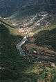
After confluence, Cem flows generally southwest for 26.5 kilometres (16.5 mi) and crosses into Montenegro, near Grabom.[2] A border crossing is also located after this village. Then the river flows through the villages of Tuzi municipality for 32.3 kilometres (20.1 mi) before flowing into the Morača just south of Podgorica near Mitrovići and Mojanovići. The river and its terrain in Montenegro are divided into two parts. It firstly forms a steep canyon and then slowly crosses into the Zeta plain, part of it called Ćemovsko polje after the river. In the field, Špiro Mugoša Airport stands between Cem and Ribnica and further west the Podgorica Airport is found. In this part, land occupation becomes more urbanized and industrialized.[4]
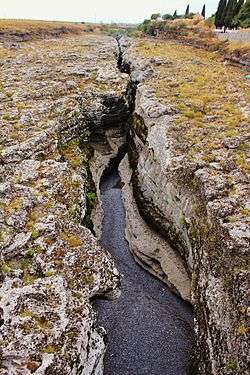
The Cem canyon (Kanjon Cijevne/Kanioni i Cemit) is 12 km long and has a depth of 903 m.[5] It is the natural habitat of many animal, insect and plant species. The canyon starts at the Albania-Montenegro border and forms a distinct geomorphological formation that crosses into Ćemovsko polje roughly before Dinosha near Gurrec.[4]
Geology

The geomorphological features of the Cem basin have their origin in the tectonic activity of the Alpine orogeny, which formed the Dinaric Alps and its southern range, the Prokletije in the Late Mesozoic and Cenozoic era up until today. Specifically, the Cem basin is in the High Karst Unit. In this sub-unit, tectonic activity creates a vertical uplifting of landmasses and carbonate rocks are a large part of the landscape, which is defined by fluvial processes like the deposition of carbonate sediments by the river's streamflow. As the Prokletije have had glacial features, thus a high accumulation of water, the end of the Ice Age saw a general increase of Cem's discharge, which in turn enhanced fluvial processes in the basin.[6][7]
Heavy concentration of limestone has enabled the formation of uvalas, caves and other karst formations.[8] As water is retained in limestone, denudation of geological formations decreases.[9] The result of these interconnected processes is that Cem flows mostly through elevated, vertical and steep terrain that forms canyons, but crosses into small valleys where non-carbonate rocks have allowed horizontal erosion to take place like in the valley of Tamara. Then, the river exits high elevation areas and flows towards the Morača as the relief flattens and a polje is formed by karst processes.[10]
Drainage Basin
The drainage basin of Cem encompasses 368 square kilometres (142 sq mi) and is part of the Adriatic river basin along with other rivers that empty into Lake Skadar, a total area of 6,560 square kilometres (2,530 sq mi). 238 km² of the basin are in Albania, where the river and its tributaries originate, and 130 km² in Montenegro.[2] In the north, it borders the basin of Vermosh river and in the east that of Lëpushë river. In the south, Cem's basin ends near Bogë.[3]
The river's elevation ranges from above 1,250 m to no more than 50 m. Its elevation drop forms waterfalls of more than a 50-meter height in Montenegro. Annual precipitation is about 2,500 mm - November being the highest point (361 mm) and July the lowest (69.9 mm). Snowfall occurs mainly in the winter months but can be observed even in May. There is a 40-day period of annual snowfall and an accumulation average of 70 m.[11]
Cem is affected by a continental climate in its upper part and a Mediterranean one as it reaches the Morača.[4] Annual temperature is around 6.8-7 °C - January being the coldest month at -3 °C and July the hottest at 15.7-20 °C. Water temperature ranges from 5 °C in the spring to 13 °C in the summer. There are three local winds that affect Cem in Albania.[12] Murlani is a dry and cold northern and northeastern wind that blows towards the Adriatic. Shiroku and Juga are humid and warm southern winds that are associated with a rainy period.[12]
Discharge
The river's streamflow increases as tributaries and springs pour into it. Elevation and other morphological features also cause variations in its discharge. In general, the upper part of Cem in Albania has a lower discharge than the flow of Cem through the canyon in Montenegro, where Cem has increased streamflow as it moves through declining elevation. When it reaches the Zeta plain, its streamflow is again reduced as it pours into the Morača.[13]
Cem of Vukël contributes 10.2-10.5 m³/s to the river. Measurements at Tamarë, where the confluence with Cem of Selcë is located, show an average discharge of 13.99-14.4 m³/s. As the river passes into Montenegro near Grabom karstic springs in Dverbta and Brezhda increase its streamflow.[11] After this point the average discharge through the canyon is 24.86 m³/s, but as it crosses into the valley, it can drop even below 5 m³/s in the dry summer months. The maximal discharge rate of the river has been observed in May and has reached 41,6m³/s.[14]
Causes of the flow decrease are use in the water supply network and environmental factors linked to climate change. The climatic interruption of the water cycle has led to the cyclical decrease of rainfall, groundwater and karstic springs water yield to the river.[15] This trend of flow decrease was observed in the Trgaj measurement station near Dinosha, in 2019, where summer flow was at a very low 3 m³/s. As Cem pours into Morača, it can contribute up to 35 m³/s to the total discharge of 210 m³/s of that river into Lake Shkodra.[16]
Ecosystem

The ecosystem of the Cem river, valleys and canyons form an area of very high biodiversity. The riparian zones of Cem support hundreds of plant and animal species endemic to the region. Mammals include wild boars, brown bears red foxes, brown hares, pine martens and the - until recently - endangered Eurasian otter.[17] A complete survey of the total number of mammal species in Cem has not yet been undertaken.[18]
Many bird species live on the banks of Cem, principally in its canyon which is an Important Bird Area. Short-toed snake eagles, Levant sparrowhawks and the rock partridge use the canyon for breeding and nesting in the summer months.[19] The Egyptian vulture, an endangered species - once very common in the Balkans - lived in the canyon until 1997, when it became extinct in Cem as in many other areas in the Balkans. In Albania, 130 bird species in total have been identified in Cem and its tributaries.[20][21]
There live 22 species of fish in the river including endemic marble trout and eel.[22] Cem's elevation range affects flora distribution zones. In altitude between 900–1200 m oak trees are very common in Selcë and Vukël, but as elevation drops pomegranates become much more common. In the river basin and wider area about 40% of the total plant species found in the country have been identified.[23] In the Cem canyon there have been identified 813 plant species which increase to a total of 959 in the wider canyon area.[24] Cem canyon is host to a quarter of the total plant species of Montenegro.[25]
Identification of flora in Cem hasn't been completed. In 2018, the moss species Fissidens fontanus was identified in Cem near Podgorica and Sitnica. This is the first time the species is reported in Montenegro.[26]
Environmental issues
In Albania until the 1990s, Kelmendi's geographical position as a heavily guarded border zone and lack of industrial development projects preserved Cem's ecosystem. Ecological indicators and water quality assessment have consistently shown that Cem exhibits among the lowest pollution levels in the country.[27] While in the post-1990 transition era there were no adequate monitoring stations, since 2008-2010 environmental monitoring has become more frequent. Within Albania, in recent years Cem's ecosystem and very high biodiversity are threatened by the planned installation of 14 small hydropower plants.[28] As of 2020, construction of two units has begun, in Muras (2 mW) and Dobrinjë (1 mW), both in Cem of Selcë.[29][30]
In Kelmend, locals have protested strongly against the projects since water volume for irrigation use will decrease significantly and impact on the ecosystem will endanger ecologically sustainable development in the entire area. In Podgorica, after protests by environmental activists, the Montenegrin government requested full documentation of the Strategic Impact Assessment of the proposed hydropower plants on the river flow as both countries have signed the Espoo Convention, which requires transnational consultation on projects that impact natural resources across borders. The Albanian government has declared that river flow towards Montenegro won't be affected.[28] The same process of hydropower expansion is also planned for many of the free-flowing rivers of the Balkans including Morača, where Cem debouches.[31]
In Montenegro, Cem is ranked as one of the cleanest rivers in the country. As in Albania, the part nearest to the border before the 1990s was heavily militarized and no activity was allowed in its vicinity. The municipality of Podgorica declared the river canyon a "natural monument" in 2017. Environmental organizations argue that despite formal commitment about Cem's protection, Montenegrin authorities have consistently allowed sewage pollution, gravel exploitation and unauthorized construction.[32] In the lower part, after the canyon, industrialized agriculture and the Podgorica landfill have contributed to the deterioration of surrounding land quality. After the split of Tuzi from Podgorica, across which Cem flows, the municipality of Tuzi has also voted in favor of a resolution on the protection of the river in 2018.[32]
As a result of climate change inflow and outflow from Cem have steadily decreased in the 2010s.[15]
Economy
Economic activities and development in settlements in Cem's basin and course are deeply affected by the ecosystem of the river. These are communities that rely on agriculture, livestock and alpine forestry. Small-scale, sustainable trout farming has also developed in recent years In Albania, Kelmend was before the 1990s a key area of wood production. In Montenegro, soil fertility of the river basin has also allowed viticulture to develop. Plantaže, a local wine producer, owns on the banks of Cem one of the largest vineyards with around 11.5 million grapevines.[33] Many seasonal workers move through cross the border every year to cover the needs of the seasonal economic activities in farming and forestry.[34]
The collapse of the economies of the Eastern Bloc had a profound economic effect in both countries. Many agricultural cooperatives shut down and public services deteriorated during the 1990s and 2000s. As a result, there is a heavy flow of migration towards Italy, Greece and mainly the US, where a large community from Tuzi and Malësia lives in Detroit.[34]
In Kelmend, a slow and gradual reorganization of the economy happened in the 2000s and 2010s with an orientation towards ecologically sustainable development. Medicinal agriculture developed in combination with alpine tourism that has become an important source of income for many villages.[35]
History
Human activity in the Cem basin has been recorded since the late Copper Age near Rakića Kuće in Tuzi. The tumulus of Rakića Kuće contained nine skeletons and clay figurines with some anthropomorphic attributes.[36] The area of Tuzi remained an area of settlement in the Bronze Age. Tumuli and burial artifacts have been found around Dinosha and Lopari in the period that ranges from the Bronze Age to the Hellenistic Period.[37]
Illyrian tribes are found in Cem in the beginning of classical antiquity. The best known in recorded history are the Ardiaei, Labeatae and Docleatae. Artifacts from this era have been excavated in Selcë, where a hoard of coins that were minted by king Gentius (181-168 BC) was found.[38] Reports on these findings were first published by archaeologist Arthur Evans after 1880.[38]
In the centuries of Roman rule that followed, the Cem region served mostly as a route between the urbanized centers of the Roman Balkans in the province of Praevalitana. Water from the river was transported to Doclea for the supply of local Roman townships from the 1st to the 6th century AD.[39] Some traces of fortifications from this era remain. Among those fortifications, Procopius (6th century) mentions Clementiana, a location that is connected to modern-day Kelmend.[40] The fort system is related with the Ostrogothic invasion of Dalmatia in the late 5th century, which turned former Praevalitana in a border area of the Eastern Roman Empire.[41] Justinian secured the area in the Gothic War in 535.[41]
Avar-Slavic raids and incursions caused the fall of many post-Roman routes and urban centers. New Slavic polities emerge in the region in the 11th century onwards: Duklja later as part of Raška and the Serbian Empire. The Venetian Republic appears as a dominant force in the late 14th century. Until the consolidation of Ottoman rule in the 15th century, the Zeta plain and Cem were a borderland between Venice, the Principality of Zeta and local Albanian tribes (fis) and rulers.[42]
The Albanian fis pattern of settlements on the banks of Cem continued in the Ottoman period and even after the division of Cem between Montenegro and Albania in the Balkan Wars. Today, the history of these communities is retained as an important part of the cultural heritage of the region. The Ottomans placed the Cem area under the jurisdiction of the Sanjak of Scutari to control the Catholic clans of Malësia. Nevertheless, in practice the villages of Cem were semi-autonomous throughout the era. The tribal division was as follows: Cem of Selcë and Cem of Vukël fell within Kelmendi tribal territory.[43] As Cem passes into modern Montenegro after Grabom, the settlements of right-bank Cem were part of Triepshi. The villages of left-bank Cem were part of Hoti and beyond that the river passed into Gruda.[44]
Historical accounts about Cem increased in second half of the 19th century as the Great Power took interest in the region for their geopolitical interests and the Principality of Montenegro expanded into Ottoman territory. The Congress of Berlin in 1878 awarded Triepshi to Montenegro but this decision met resistance in that area as did the - ultimately annulled - annexation of Tuzi by Montenegro, so the border area remained vague until the Balkan Wars.[45] For the next 30 years the Cem basin was in a state of conflict between the Ottomans, the Montenegrin Principality and the Albanian national movement with ever-changing tactical alliances between those forces and the involvement of Great Powers like Austria and Russia. Of the many campaigns, battles and skirmishes of that period, the battle on the hill of Deçiq in the Albanian revolt of 1911 against the Ottomans is marked as one the better known and important events.[46] It is possibly one of the first times the Albanian flag was hoisted in a battle after the 15th century. This action was undertaken by Ded Gjo Luli of Hoti who is a celebrated figure in the Cem area with yearly events in his honor.[46]
The London Peace Conference in 1912-1913 set the Albanian-Montenegrin border which remains to this day the boundary that divides Cem. A part of the population from the villages around Cem that became part of Montenegro, moved to Albania in the years that followed the demarcation and created villages like Hot i Ri (New Hoti) in 1932 and Gruda e Re (New Gruda) in 1930 across the border near Shkodër, in what is now known as Rrethinat.[47] In 1941, the Montenegrin part of the Cem basin passed under Albanian control by Fascist Italy as part of its campaign to gain local support for its protectorate over Albania.[48] After the war, the border was re-established at the 1912-1913 demarcation line.[49]
Settlements

Cem traverses Kelmend and Tuzi municipalities in Albania and Montenegro respectively as well as some settlements in Podgorica municipality (Mitrovići, Mojanovići, Mahala, Ljajkovići). Kelmend has a population of about 3,000, Tuzi stands at 12,000 and the combined population of the Podgorica settlements is about 4,700.[50][51]
In terms of ethnicity and religion, Kelmend is Albanian and Catholic. In Tuzi about 2/3 are Catholic Albanians and some are Muslim Albanians, while the rest are Orthodox Montenegrins and Muslim Bosniaks. In Mitrovići, Mojanovići, Mahala and Ljajkovići about 85% are Orthodox Montenegrins and 15% Orthodox Serbs.[50]
Over the years, the Cem basin experienced heavy migration towards Europe and the USA.[34] The two principal municipalities of the area, Kelmend and Tuzi have been greatly affected by the population drain of immigration. The settlements around the area, where Cem pours into Morača are becoming part of the urban agglomeration into which Podgorica is transforming.[52]
Cem's significance in the region is reflected in the use of the river as a symbol of both state institutions and non-state groups. For example, Tuzi municipality uses the river in its flag and in Ljajkovići there is a football club (FK Bratstvo Cijevna) that is named after it.[53]
Gallery
 The Valley of the Cijevna slightly above the Montenegrin-Albanian border
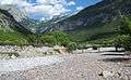 Dried out riverbed of Cem i Vuklit
 Tamara Gorge in Albania
See also
- List of rivers in Albania
- List of rivers in Montenegro
Sources
Citations
- Mayer 1957, p. 215.
- Marojević 2014, p. 4
- Kodhelaj & Hasalami 2019, p. 18.
- Marojević 2014, p. 5
- Djurović & Petrović 2007, p. 16.
- Djurović & Petrović 2007, pp. 14–18.
- Mrdak & Hadžiablahović 2015, p. 16
- Mrdak & Hadžiablahović 2015, p. 17
- Djurović & Petrović 2007, pp. 15, 18.
- Djurović & Petrović 2007, pp. 15, 16, 18.
- Marojević 2014, p. 6
- Kodhelaj & Hasalami 2019, p. 16.
- Mrdak & Hadžiablahović 2015, p. 20
- Mrdak & Hadžiablahović 2015, p. 19
- Mitrović 2019, pp. 83–85.
- Dhora 2016, p. 26.
- Marojević 2014, p. 12
- Marojević 2014, p. 10
- Marojević 2014, p. 9
- "Comments on the Special Purpose Spatial Plan for the Skadar Lake National Park". Centre for Protection and Research of Birds. p. 2. Retrieved 7 January 2020.
- Méndez & Donázar 2015, p. 3.
- "Fish Database - Save the Blue Heart of Europe". balkanrivers.net. Retrieved 1 July 2019.
- Marojević 2014, p. 11
- Mrdak & Hadžiablahović 2015, p. 39
- "IBA Montenegro". CZIP. Center for Protection and Research of Birds. Retrieved 4 January 2020.
- Anđić 2018, p. 2.
- Meco et al. 2014: "Gjendja "shumë mirë" përfshin të gjitha stacionet, të cilat përgjithësisht gjenden në pjesët e sipërme malore të rrjedhjeve, ku prania dhe ndikimi ndotës i njeriut në ujëra është i ulët, si në Lurë, Valbonë, Cem, Vermosh etj."
- Kajosevic, Samir (2019). "Montenegro to Grill Albania Over River Power Plants". Balkan Insight. Retrieved 2 January 2020.CS1 maint: ref=harv (link)
- "Muras HS" (PDF). Ministry of Energy of Albania. Retrieved 2 January 2020.
- "Dobrinjë HS" (PDF). Ministry of Energy of Albania.
- "NGOs demand: Government gives up the construction of small hydro power projects on the Moraca River". EU Info Centre Montenegro. Retrieved 6 April 2020.
- "Asking Europe to help with the Cijevna" (PDF). Vijesti. Retrieved 2 January 2020.
- "Ćemovsko polje vineyard". Plantaže.com. Plantaže. Retrieved 7 January 2020.
- Axhemi 2019, pp. 288–291.
- Axhemi 2019, pp. 284–282.
- Bugaj 2013, p. 430.
- Lulgjuraj 2019, p. 3.
- Selami 1972, p. 357.
- Radulović 1997, p. 63.
- Šufflay 2000, p. 136.
- Vukotić 2019, p. 7
- Fine 1994, p. 515.
- Odile 1989, p. 46.
- von Hahn & Elsie 2015, p. 129.
- Ahrens 2007, p. 266.
- Verli 2014, p. 64.
- Rustja 2014, p. 54.
- Singleton 1985, p. 183.
- Kamusella 2008, p. 21.
- "Census 2011 data - Montenegro". Monstat. Statistical Office of Montenegro. Retrieved 15 February 2020.
- "Settlements of Shkodër County - 2011 Census" (PDF). Statistical Office of the Republic of Albania. 2016-03-03. p. 85. Archived from the original (PDF) on 2016-03-03. Retrieved 7 April 2020.
- "Podgorica Climate Change Adaptation" (PDF). Municipality of Podgorica. p. 8. Retrieved 7 April 2020.
- Camaj, Nikollë (2019). "Përkrahje zgjidhjes së Stemës së komunës, por edhe të drejtës në reagim". Malesia. Retrieved 2 April 2020.
Bibliography
- Ahrens, Geert-Hinrich (2007). Diplomacy on the Edge: Containment of Ethnic Conflict and the Minorities Working Group of the Conferences on Yugoslavia. Johns Hopkins University Press. ISBN 9780801885570. Retrieved 15 January 2020.CS1 maint: ref=harv (link)
- Anđić, Branko (2018). "Fissidens fontanus, a new species to Montenegro". Lindbergia. 41. doi:10.25227/linbg.01094. Retrieved 2 January 2020.CS1 maint: ref=harv (link)
- Axhemi, Sokol (11 June 2019). "Heritage of borderland and population development trends in the cross-border area of Albania-Montenegro" (PDF). Studia z Geografii Politycznej i Historycznej. 7 (7). doi:10.18778/2300-0562.07.12. Retrieved 7 January 2020.CS1 maint: ref=harv (link)
- Bugaj, Urszula (2013). "Bronze-Age stone tumuli on Planinica hill, obs. Tuzi, Montenegro". Sprawozdania Archeologiczne. 65: 427–433. Retrieved 9 January 2020.CS1 maint: ref=harv (link)
- Dhora, Dhimitër (2016). "Liqeni i Shkodrës [Lake of Shkodra]" (PDF). University of Shkodra. Retrieved 8 January 2020.CS1 maint: ref=harv (link)
- Djurović, Predrag; Petrović, Aleksandar (2007). "Large Canyons in Dinaric and Prokletije Mountains Region of Montenegro" (PDF). Geographica Pannonica. 11 (11): 14–18. doi:10.5937/GeoPan0711014D. Retrieved 22 January 2020.CS1 maint: ref=harv (link)
- Fine, John Van Antwerp (1994). The Late Medieval Balkans: A Critical Survey from the Late Twelfth Century to the Ottoman Conquest. University of Michigan Press. ISBN 978-0-472-08260-5.CS1 maint: ref=harv (link)
- Kamusella, Tomasz (2008). The Politics of Language and Nationalism in Modern Central Europe. Springer. ISBN 0230583474. Retrieved 7 April 2020.CS1 maint: ref=harv (link)
- Kodhelaj, Saidjon; Hasalami, Agim (2019). "Environmental Assessment Plan of Hydropower Station "Ura e Tamarës"" (PDF). Agjencia Kombëtare e Mjedisit [National Environmental Agency] (in Albanian).CS1 maint: ref=harv (link)
- Lulgjuraj, Anton (2019). "PREHISTORIC FORTIFICATION IN LOPARI AND GRAVEYARD IN DINOSHA VILLAGE (MONTENEGRO)". Anglisticum Journal. 8 (4). doi:10.5281/zenodo.2886234. Retrieved 9 January 2020.CS1 maint: ref=harv (link)
- Marojević, Jelena (2014). "Plani i veprimit të përbashkët për mbrojtjen ekologjike të lumit Cem dhe zhvillimi i qendrueshëm mjedisor në zonën ndërkufitare [Mapping of common action plan for trans-border protection of Cem]" (PDF). GreenHome. Albania-Montenegro CrossBorder Cooperation Programme. Retrieved 31 December 2019.CS1 maint: ref=harv (link)
- Mayer, Anton (1957). Die Sprache der alten Illyrier. In Kommission bei R. M. Rohrer. Retrieved 3 January 2020.CS1 maint: ref=harv (link)
- Meco, Marjol; Ndoj, Eriselda; Nika, Olsi; Miho, Aleko (2014), Vështrim mbi cilësinë biologjike të ujërave sipërfaqësore shqiptare, University of Tirana, retrieved 2 January 2020CS1 maint: ref=harv (link)
- Méndez, María; Donázar, José (2015). "Genetic analysis of Egyptian vulture (Neophron percnopterus) in the Balkans and Turkey" (PDF). Life+ Project. LIFE+ project “The Return of the Neophron”. Retrieved 7 January 2020.CS1 maint: ref=harv (link)
- Mitrović, Luka (2019). "The impact of the climate change on the groundwater regime in the area of the Podgorica-Shkodër Basin". Regionalni Vodovod Crnogorsko Primorje. Retrieved 8 January 2020.CS1 maint: ref=harv (link)
- Mrdak, Duško; Hadžiablahović, Sead (2015). "STUDIJA ZAŠTITE ZA SPOMENIK PRIRODE "KANJON CIJEVNE [Environmental protection study of the natural monument "Kanjon Cijevne"] - chapters on Geology and Flora" (PDF). Agencija za zaštitu životne sredine Crne Gore [Environmental Protection Agency of Montenegro]. Retrieved 4 January 2020.CS1 maint: ref=harv (link)
- Odile, Daniel (1989). "Montagnes Tribales et Coutumiers". L' Ethnographie. 2. Retrieved 5 April 2020.CS1 maint: ref=harv (link)
- Radulović, Vasilije (1997). "The waters of the Lake Skadar and its neighbouring aquifers as water supplying sources". Prirodne Vrijednosti I Zaštita Skadarskog Jezera: Radovi Su Naučnog Skupa : Podgorica, 8-9. Novembar 1995. Retrieved 5 April 2020.CS1 maint: ref=harv (link)
- Rustja, Dritan (2014), HAPËSIRA PERIURBANE E SHKODRËS: PËRDORIMI I TERRITORIT DHE VEÇORITË E ZHVILLIMIT SOCIAL-EKONOMIK [The Suburbia of Shkodra: Land Use and Details of Social and Economic Growth] (PDF), University of Tirana, retrieved 15 January 2020CS1 maint: ref=harv (link)
- Selami, Hasan (1972). "Prerjet monetare të Skodrës, Lisit dhe Gentit (Përpjekje për një rishqyrtim të problemit". Iliria. 2. doi:10.3406/iliri.1972.1148. Retrieved 9 January 2020.CS1 maint: ref=harv (link)
- Singleton, Fred (1985). A Short History of the Yugoslav Peoples. Cambridge University Press. p. 183. ISBN 9780511608070. Retrieved 15 January 2020.CS1 maint: ref=harv (link)
- Šufflay, Milan (2000). Izabrani politički spisi. Matica hrvatska. Retrieved 20 March 2020.CS1 maint: ref=harv (link)
- Verli, Marenglen (2014). "The role of Hoti in the uprising of the Great Highlands". Studime Historike (1–2). Retrieved 5 February 2020.CS1 maint: ref=harv (link)
- von Hahn, Johan Georg; Elsie, Robert (2015). The Discovery of Albania: Travel Writing and Anthropology in the Nineteenth Century. I. B. Tauris. ISBN 1784532924.CS1 maint: ref=harv (link)
- Vukotić, Vukota (2019). "Litteratura Praevalitana - Form of Literature from the 1st to the 7th century". Muzejski Glasnik. 14. Retrieved 10 April 2020.CS1 maint: ref=harv (link)
| Wikimedia Commons has media related to Cem River. |
| Urban municipalities |  | |
|---|---|---|
| Neighborhoods | ||
| Municipality settlements | List
| |
| Geography | ||
| Landmarks |
| |
| Culture | ||
| Sports venues | ||
| Sport clubs |
| |
| Events | ||
| Education |
| |
| Media | ||
| Shopping malls | ||
| Companies | ||
| Transportation | ||