Cerro Batoví
Cerro Batoví is a hill in Uruguay, with an altitude of 224 metres (734.9 ft). It is situated 25 km (15.5 mi) away from the city of Tacuarembó.
| Cerro Batoví | |
|---|---|
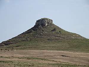 Cerro Batoví, situated near Tacuarembó | |
| Highest point | |
| Elevation | 224 m (735 ft) |
| Listing | Breast-shaped hills |
| Coordinates | 31°52′33″S 56°00′41″W |
| Naming | |
| English translation | Cerro (Hill in Spanish); Batoví (Breast of a virgin in Guaraní) |
| Language of name | Spanish/Guaraní |
| Pronunciation | Spanish: [ˈθero βatoˈβi] |
| Geography | |
 Cerro Batoví Uruguay | |
| Location | Tacuarembó, Tacuarembó Department, Uruguay |
| Parent range | Cuchilla de Haedo |
| Geology | |
| Age of rock | Precambrian |
| Mountain type | Hill |
| Climbing | |
| Easiest route | Hike |
Location and features
It is located in the Tacuarembó Department, in a range of hills named Cuchilla de Haedo. Batoví means "breast of a virgin" in the Guaraní language and the hill has this name due to its curious shape.
Cerro Batoví is considered the symbol of the Tacuarembó Department.
See also
External links
- (in Spanish) Enciclopedia Geográfica del Uruguay.
| Wikimedia Commons has media related to Cerro Batoví. |
Capital: Tacuarembó | ||
| Towns and villages | 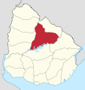 | |
| Sights | ||
This article is issued from Wikipedia. The text is licensed under Creative Commons - Attribution - Sharealike. Additional terms may apply for the media files.