Castleknock (civil parish)
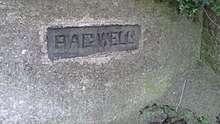
Castleknock is a civil parish in the ancient barony of Castleknock. The townland of Castleknock itself is the location of the eponymous "Cnucha's Castle" - Castleknock Castle. The town with the biggest population in the parish is Blanchardstown. Abbotstown Demense was the principal seat in the civil parish. Along with other civil parishes in Ireland, its use as a unit of local administrative unit was gradually replaced by the creation of Electoral Divisions in the Local Government (Ireland) Act of 1898.
History
Like all civil parishes in Ireland, this civil parish is derived from, and co-extensive with, a pre-existing parish of the Church of Ireland.
In 1773, an Act of the Privy Council united the parish with the curacies of Clonsilla and Mulhuddart. In 1837, Lewis reported in his directory that the living (of the ecclesiastical parish) was a vicarage in the Diocese of Dublin which was: "... endowed with a portion of the great tithes, and united to the prebend of Castleknock and the rectory of Clonsillagh and curacy of Mullahidart, with cure of souls: it is in the patronage of the Bishop.".[1] The two churches noted by Lewis in the vicarial union, one at Castleknock, the other at Clonsilla, are extant and in use by the Church of Ireland community. The former was rebuilt by a loan of £1000 from the Board of First Fruits and large subscriptions, in 1810. In 1831, the population of the parish, including Blanchardstown was 4251 people of which 3409 were Catholic.[2]
Location and composition


The core of the parish is centred on the townland and village of the same name. The townland at the northern extremity is Huntstown, not to be confused with Huntstown and Littlepace in the neighbouring parish of Clonsilla.To the south, it is bounded by the River Liffey and Chapelizod. To the west, it is bounded by the townland of Annefield. To the east lies the 8th lock of the Royal Canal and the Cabra Gate of the Phoenix Park.
Populated places

Church of Ireland, Castleknock

Catholic Church, Castleknock
Populated places in the civil parish include: Blanchardstown, Castleknock, Ashtown, Cabra, Corduff, Laurel Lodge.
Townlands


Within the civil parish of Castleknock, there are 22 townlands per the table below. For convenience, the table groups the townlands by their location in one of the modern local authority areas. Some townlands, however, straddle both areas.
| Modern Local Authority Area |
Name in Irish | Name in English | Acres |
|---|---|---|---|
| Dublin City | Baile an Ásaigh | Ashtown (partly) | 278 |
| Baile Pheiléid | Pelletstown | 259 | |
| An Chabrach | Cabra | 457 | |
| Caisleán Cnucha (cuid de Pháirc an Fhionnuisce) | Castleknock (part of Phoenix Park) (partly) |
1020 (787) | |
| Fingal | Baile an Aba | Abbotstown[4 1] | 101 |
| Baile an Ásaigh | Ashtown (partly)[4 2] | 278 | |
| Baile an Chairpintéaraigh | Carpenterstown[4 3] | 166 | |
| Baile an Déanaigh | Deanestown[4 4] | 173 | |
| Baile an Diosualaigh | Diswellstown[4 5] | 418 | |
| Baile an Huntaigh | Huntstown[4 6] | 299 | |
| Baile an Phóirtéaraigh | Porterstown[4 7] | 219 | |
| Baile Bhlainséir | Blanchardstown[4 8] | 454 | |
| Baile Mhistéil | Mitchelstown[4 9] | 154 | |
| Baile Scriobail | Scribblestown[4 10] | 272 | |
| Baile Sheáin | Johnstown[4 11] | 67 | |
| An Chabrach | Cabra | 457 | |
| Caisleán Cnucha (cuid de Pháirc an Fhionnuisce) | Castleknock (part of Phoenix Park) (partly) |
1020 (787) | |
| Ceapach | Cappoge or Cappagh | 698 | |
| Cnoc na gCaorach | Sheephill | 349 | |
| An Chorr Dhubh | Corduff | 353 | |
| Dún Sinche | Dunsink | 423 | |
| Páirc Anna | Annfield | 19 | |
| Snugborough | Snugborough | 53 | |
| Steach Gob | Astagob | 93 | |
References
From "Placenames Database of Ireland". Logainm. Department of Culture, Heritage and the Gaeltacht. Archived from the original on 19 August 2013. Retrieved 15 March 2020.
- "Abbotstown | logainm.ie". logainm.ie. Retrieved 26 March 2016.
- "Ashtown | logainm.ie". logainm.ie. Retrieved 26 March 2016.
- "Carpenterstown | logainm.ie". logainm.ie. Retrieved 26 March 2016.
- "Deanestown | logainm.ie". logainm.ie. Retrieved 26 March 2016.
- "Diswellstown | logainm.ie". logainm.ie. Retrieved 26 March 2016.
- "Huntstown | logainm.ie". logainm.ie. Retrieved 26 March 2016.
- "Porterstown | logainm.ie". logainm.ie. Retrieved 26 March 2016.
- "Blanchardstown | logainm.ie". logainm.ie. Retrieved 26 March 2016.
- "Mitchelstown | logainm.ie". logainm.ie. Retrieved 26 March 2016.
- "Scribblestown | logainm.ie". logainm.ie. Retrieved 26 March 2016.
- "Johnstown | logainm.ie". logainm.ie. Retrieved 26 March 2016.
Other sources
- Lewis, "Topographical Dictionary of Ireland", 1837
- The History of the County of Dublin, John D'Alton, 1838
Places in the county of Fingal | |||||||||||||
|---|---|---|---|---|---|---|---|---|---|---|---|---|---|
| Towns and large suburbs | 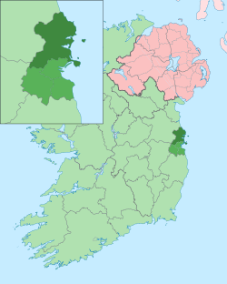 | ||||||||||||
| Villages and smaller suburbs | |||||||||||||
| Baronies broken out by civil parish (* denotes article not on the civil parish or barony specifically but on the modern district, village or town of the same name) |
| ||||||||||||
| Wikimedia Commons has media related to Castleknock (civil parish). |