Captaincy of Pernambuco
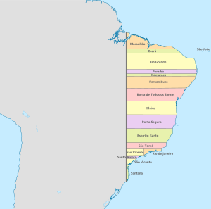
The Captaincy of Pernambuco or New Lusitania (Portuguese: Nova Lusitânia)[1] was a hereditary land grant and administrative subdivision of northern Portuguese Brazil during the colonial period from the early sixteenth century until Brazilian independence. At the time of the Independence of Brazil, it became a province of United Kingdom of Portugal, Brazil and the Algarves. Captaincies were originally horizontal tracts of land 50 leagues[Note 1] wide extending from the Atlantic Ocean to the Torsedillas meridian.
.svg.png)
At the time of colonial Brazil, the Captaincy of Pernambuco was one of only two prosperous captaincies (the other being Captaincy of São Vicente), thanks to growing sugar cane. During the early colonial period, it grew by acquisition of failed captaincies to the north. At its height, the Captaincy of Pernambuco included the territories of the modern states of Pernambuco, Paraiba, Alagoas, Rio Grande do Norte, Ceará and the western portion of Bahia (north and west of the São Francisco River) having thus its southern border with Minas Gerais (the northwest end of Minas was the final part of the São Francisco River District: a Pernambuco Captaincy advanced a little further into the mining territory of present-day Bahia). In the years just before Brazilian independence, the captaincy was reduced by repartitioning of several previously merged captaincies, until today's state with the same name was left.
History

Etymology
The name pernambuco is a Tupi Indian name for the coastal reefs found along the region's Atlantic shoreline.
Founding
According to the charter grant passed by D. João III on March 10, 1534, the donee of Pernambuco was Duarte Coelho Pereira, who was a distinguished gentleman in the Portuguese campaigns in India. The captaincy of width 60 leagues stretched between the Igaraçu River (a tributary of Canal de Santa Cruz southern portion) and the São Francisco River. He called it New Lusitania, after the poetic name for Portugal.
Part of a series on the |
|---|
| History of Brazil |
 |
|
|
|
|
|
|
|
|
|
- The text of the original grant letter in Portuguese can be read here
The boundary to the north was the parallel marking the southern boundary of the Captaincy of Itamaracá; to the south, the Rio São Francisco far shore; to the west the Tordesillas meridian; to the east, the Canal de Santa Cruz and Atlantic Ocean. The captaincy originally included what is today the state of Alagoras.
Upon receiving the donation, Duarte Coelho Pereira went to Brazil with his wife, children and many relatives. They landed on the shores of Santa Cruz canal, where there was a nucleus of settlement in the Porto dos Marcos. He advanced to the mouth of the Igaraçu River, Pernambuco, where he founded the village of the same name. He built the Church of Santos Cosme e Damião, the first in Brazil, giving the administration of the village to Afonso Gonçalves, and headed south. On a hill, he built a fort (Castelo Duarte Pereira), a chapel and houses for themselves and for the settlers, which became the settlement of Olinda, constituted a village by the Charter Act passed on March 12, 1537. The sugar mills of Duarte Coelho and his wife, and that of his brother-in-law Jerónimo de Albuquerque on the Beberibe River near Olinda, were the first in the captaincy. The small port of Olinda was negligible, with no depth to receive large vessels crossing the Atlantic Ocean. In turn, Recife, a town named by the first donee for its arrecife dos navios (reef or causeway ships - Recife was shielded by a long barrier reef) became the main port of the captaincy.
Everything was organized to perform registration and donation of land, administration of justice, civil record-keeping, and defense against the Caetés and Tabajaras Indians. When Coelho died in 1554, he bequeathed to his children a flourishing captaincy.
In Olinda, administrative headquarters of the captaincy, settled the civil and ecclesiastical authorities, the Jesuit College, the main monasteries and small dock Varadouro. In the late sixteenth century, about 700 families lived there, not counting those who lived on the plantations, which housed 20 to 30 residents.
From land bordering the São Francisco River, Pernambuco expanded northeast along the Atlantic coast, much exceeding in width the 60 leagues established in the letter of donation. The captaincy reached 12,000 square leagues (376,000 km²), becoming the largest land area among all that the king distributed.[2]
Gold and diamonds
Province of Pernambuco
In 1821, the captaincy of Pernambuco became the province of Pernambuco in the Kingdom of Brazil. Its borders have remained relatively unchanged since that time, with the slight change of ceding the south bank of Rio Francisco to Bahia.
Administrative evolution

Pernambuco (Captaincy of Duarte Coelho, from 1535). In 1799 it was divided into the provinces of Pernambuco, Ceará, Rio Grande do Norte, and Paraíba. In 1817 it was divided again into Alagoas and Pernambuco. It was governed by donatarios until 1576, when it began to employ capitaes-mors appointed by the donatarios. After the Dutch occupation ended in 1654, the Portuguese Crown took over administration. In 1716, the last donatario sold his rights back to the Crown, and Pernambuco became a Crown colony.[3]
- 1535 Donátaria Nova Lusitania.
- 1575 renamed captaincy of Pernambuco.
- 1582 captaincy of Paraíba subordinated to Pernambuco
- 16 Jan 1630 – 28 Jan 1654 Dutch occupation (see Dutch Brazil).
- ? Rio Grande de Norte subordinated to Pernambuco
- 1654 subsumed by Governorate (State) of Brazil
- 1656 Ceará subordinated to Pernambuco.
- 1701 captaincy of Rio Grande (Rio Grande de Norte and Paraiba) subordinated to Pernambuco.
- 10 May 1716 Crown colony, captaincy of Pernambuco.
- 1756 captaincy of Itamaraca merged into Pernambuco
- 17 Jan 1799 Ceará captaincy split from Pernambuco.
- 1799 captaincy of Paraíba do Norte (later renamed Paraiba) split from Pernambuco
- 1808 Rio Grande de Norte split from Pernambuco
- 07 Mar 1817 - 1 Jul 1817 Republic of Pernambuco (in rebellion).
- 16 Sep 1817 Alagôas captaincy split from Pernambuco.
- 28 Feb 1821 province of United Kingdom of Portugal, Brazil and the Algarves
- 07 Sep 1822 province of empire of Brazil.
- c.1634-1750s captaincy of Rio Sao Francisco (dissolved, part of Bahia, Pernambuco, Alagoras, Piaui)
Notes
- A league was ~5.6km
References
- Airton Farias. História do Ceará (in Portuguese). Armazém da Cultura. Retrieved 14 March 2016.
- Varnhagen, Francisco Adolpho de (1854-57) Historia Geral do Brazil. Rio de Janeiro: Laemmert
- Henige, David P. Colonial Governors from the Fifteenth Century to the Present, 1970
See also
|  | |||||||||||||||||||||||||||||||||||||||||||||||||||||||||||||||||||||||
|
| ||||||||||||||||||||||||||||||||||||||||||||||||||||||||||||||||||||||||
| ||||||||||||||||||||||||||||||||||||||||||||||||||||||||||||||||||||||||
| ||||||||||||||||||||||||||||||||||||||||||||||||||||||||||||||||||||||||
| ||||||||||||||||||||||||||||||||||||||||||||||||||||||||||||||||||||||||
| ||||||||||||||||||||||||||||||||||||||||||||||||||||||||||||||||||||||||