Calunium
Calunium, also known as Wery Wall, is a ruined former Roman fort atop Castle Hill in Lancaster in North West England. The first castra was founded between c. AD 60-73 within the Roman province of Britannia. The area is a protected Scheduled Ancient Monument.
| Calunium | |
|---|---|
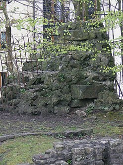 Surviving ruins of the third fort (Wery Wall) at Calunium | |
 | |
| Known also as | Lancaster Roman Fort |
| Founded during the reign of | Vespasian |
| Founded | c. 71 - 73 AD |
| Abandoned | 5th century |
| Place in the Roman world | |
| Province | Britannia |
| Nearby water | River Lune |
| Structure | |
| — Stone structure — | |
| Built during the reign of | Trajan |
| Built | c. 102 AD |
| — Wood and earth structure — | |
| Built during the reign of | Vespasian |
| Built | c. 71 - 73 AD |
| Stationed military units | |
| — Cohorts — | |
| ala Sebosiana and numerus Barcariorum Tigrisiensium | |
| Location | |
| Coordinates | 54.05150°N 2.80347°W |
| Place name | Lancaster |
| Town | Lancaster |
| County | Lancashire |
| Country | England |
| Reference | |
| UK-OSNG reference | SN643564 |
| Site notes | |
| Discovery year | 1950 |
| Condition | Earthworks and ruins |
| Controlled by | Scheduled Monument (SAM: CD129) |
The fort's name is known only in an abbreviated form; the only evidence of the fort's name is a Roman milestone found 4 miles outside Lancaster, with an inscription ending L MP IIII, meaning "from L— 4 miles".[1] The name of the fort is probably Calunium.
History
The first fort at Calunium was built out of timber, probably around 71-73 AD, although evidence of Roman settlement in Lancaster dates back to at least the early 60s, possibly meaning that the fort was built as early as c.60 AD.[2][3] The first fort was built on a hill commanding a crossing over the River Lune.[4][5] It was expanded during the late 1st century (around 80 AD) and it was abandoned before being reoccupied again nearly a century later.
The fort was reoccupied again during the 2nd century and it was rebuilt in stone around 102 AD.[6] It was rebuilt at Vicarage Field, where only earthworks remain now. It was expanded around 330 AD to encompass all of Castle Hill, including the once isolated bath house which was built when the first fort was built. The fort underwent a few more extensions, and at its largest area it was 9–10 acres (4–4 ha).[7] The 3rd-century fort was garrisoned by the ala Sebosiana and the numerus Barcariorum Tigrisiensium.[8] The 4th century fort constituted a drastic remodelling of the 3rd-century one, while retaining the same orientation as its predecessor. The only surviving ruined wall of the 4th century fort, identified as part of the fort in 1950, is now known as Wery Wall.
The evidence suggests that the fort remained active up to the end of Roman occupation of Britain in the early 5th century, being used as an early Saxon shore fort.[9]
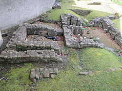
The Roman baths, of the second fort, were discovered in 1812 and can be seen near the junction of Bridge Lane and Church Street. There was presumably a bath-house belonging to the 4th-century fort. The Roman baths incorporated a reused inscription of the Gallic Emperor Postumus, dating from 262–266 AD.
References
- Rivet, A. L. F.; Smith, Colin (1979). The Place-Names of Roman Britain. London: B. T. Batsford. p. 382. ISBN 0713420774.
- Shotter, p. 5.
- I. A. Richmond: Excavations on the Site of the Roman Fort at Lancaster (1950)
- Shotter 2001, p. 3
- Champness 1993, p. 1
- Shotter 2001, p. 10
- Shotter, p. 14.
- Birley, CW- XXXIX, p. 222.
- Shotter, p. 27.