Calatrava, Negros Occidental
Calatrava, officially the Municipality of Calatrava (Cebuano: Lungsod sa Calatrava; Hiligaynon: Banwa sang Calatrava; Tagalog: Bayan ng Calatrava), is a 1st class municipality in the province of Negros Occidental, Philippines. According to the 2015 census, it has a population of 80,624 people.[3]
Calatrava | |
|---|---|
| Municipality of Calatrava | |
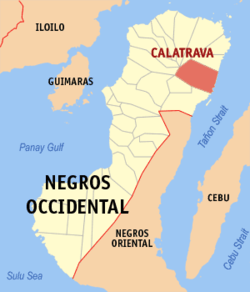 Map of Negros Occidental with Calatrava highlighted | |
OpenStreetMap 
| |
.svg.png) Calatrava Location within the Philippines | |
| Coordinates: 10°36′N 123°29′E | |
| Country | |
| Region | Western Visayas (Region VI) |
| Province | Negros Occidental |
| District | 1st district of Negros Occidental |
| Barangays | 40 (see Barangays) |
| Government | |
| • Type | Sangguniang Bayan |
| • Mayor | Marilyn A. Era |
| • Vice Mayor | Florido C. Dinapo |
| • Congressman | Gerardo P. Valmayor Jr. |
| • Electorate | 53,459 voters (2019) |
| Area | |
| • Total | 504.50 km2 (194.79 sq mi) |
| Population (2015 census)[3] | |
| • Total | 80,624 |
| • Density | 160/km2 (410/sq mi) |
| • Households | 18,380 |
| Economy | |
| • Income class | 1st municipal income class |
| • Poverty incidence | 27.62% (2015)[4] |
| • Revenue (₱) | 206,742,187.80 (2016) |
| Time zone | UTC+8 (PST) |
| ZIP code | 6126 |
| PSGC | |
| IDD : area code | +63 (0)34 |
| Climate type | tropical climate |
| Native languages | Hiligaynon Tagalog Cebuano |
Barangays
Calatrava is politically subdivided into 40 barangays.
- Agpangi
- Ani-e
- Bagacay
- Bantayanon
- Buenavista
- Cabungahan
- Calampisawan
- Cambayobo
- Castellano
- Cruz
- Dolis
- Hilub-Ang
- Hinab-Ongan
- Ilaya
- Laga-an
- Lalong
- Lemery
- Lipat-on
- Lo-ok (Poblacion)
- Ma-aslob
- Macasilao
- Malanog
- Malatas
- Marcelo
- Mina-utok
- Menchaca
- Minapasuk
- Mahilum
- Paghumayan
- Pantao
- Patun-an
- Pinocutan
- Refugio
- San Benito
- San Isidro
- Suba (Poblacion)
- Telim
- Tigbao
- Tigbon
- Winaswasan
Climate
| Climate data for Calatrava, Negros Occidental | |||||||||||||
|---|---|---|---|---|---|---|---|---|---|---|---|---|---|
| Month | Jan | Feb | Mar | Apr | May | Jun | Jul | Aug | Sep | Oct | Nov | Dec | Year |
| Average high °C (°F) | 28 (82) |
29 (84) |
30 (86) |
32 (90) |
31 (88) |
30 (86) |
29 (84) |
30 (86) |
29 (84) |
29 (84) |
29 (84) |
28 (82) |
30 (85) |
| Average low °C (°F) | 23 (73) |
23 (73) |
23 (73) |
24 (75) |
25 (77) |
25 (77) |
25 (77) |
25 (77) |
25 (77) |
24 (75) |
24 (75) |
24 (75) |
24 (75) |
| Average precipitation mm (inches) | 120 (4.7) |
87 (3.4) |
95 (3.7) |
97 (3.8) |
187 (7.4) |
263 (10.4) |
251 (9.9) |
220 (8.7) |
227 (8.9) |
268 (10.6) |
220 (8.7) |
158 (6.2) |
2,193 (86.4) |
| Average rainy days | 16.1 | 12.6 | 15.4 | 16.8 | 25.8 | 28.4 | 29.1 | 27.9 | 27.7 | 28.5 | 23.9 | 18.4 | 270.6 |
| Source: Meteoblue (Use with caution: this is modeled/calculated data, not measured locally.) [5] | |||||||||||||
Demographics
| Year | Pop. | ±% p.a. |
|---|---|---|
| 1903 | 6,385 | — |
| 1939 | 38,695 | +5.13% |
| 1948 | 53,805 | +3.73% |
| 1960 | 65,888 | +1.70% |
| 1970 | 53,151 | −2.12% |
| 1975 | 58,867 | +2.07% |
| 1980 | 58,163 | −0.24% |
| 1990 | 60,228 | +0.35% |
| 1995 | 69,902 | +2.83% |
| 2000 | 74,623 | +1.41% |
| 2007 | 78,452 | +0.69% |
| 2010 | 79,009 | +0.26% |
| 2015 | 80,624 | +0.39% |
| Source: Philippine Statistics Authority[3][6][7][8] | ||
The people in the city speak Hiligaynon and Cebuano. Filipino and English are generally understood especially in the urban areas.
Economy
The municipality of Calatrava is predominantly agricultural with almost 60% of its total land area devoted to agricultural use. Sugarcane occupies the largest share of agricultural land with almost one third followed by rice and corn. The total production per year can meet the cereal demand within the municipality with the excess being exported to nearby municipalities and cities.
Other sectors include livestock & poultry and fisheries.
References
- "Municipality". Quezon City, Philippines: Department of the Interior and Local Government. Retrieved 31 May 2013.
- "Province:". PSGC Interactive. Quezon City, Philippines: Philippine Statistics Authority. Retrieved 12 November 2016.
- Census of Population (2015). "Region VI (Western Visayas)". Total Population by Province, City, Municipality and Barangay. PSA. Retrieved 20 June 2016.
- "PSA releases the 2015 Municipal and City Level Poverty Estimates". Quezon City, Philippines. Retrieved 12 October 2019.
- "Calatrava: Average Temperatures and Rainfall". Meteoblue. Retrieved 7 May 2020.
- Census of Population and Housing (2010). "Region VI (Western Visayas)". Total Population by Province, City, Municipality and Barangay. NSO. Retrieved 29 June 2016.
- Censuses of Population (1903–2007). "Region VI (Western Visayas)". Table 1. Population Enumerated in Various Censuses by Province/Highly Urbanized City: 1903 to 2007. NSO.
- "Province of". Municipality Population Data. Local Water Utilities Administration Research Division. Retrieved 17 December 2016.
External links
- Calatrava Profile at PhilAtlas.com
- Philippine Standard Geographic Code
- Philippine census information
- Local Governance Performance Management System
Places adjacent to Calatrava, Negros Occidental | ||||||||||
|---|---|---|---|---|---|---|---|---|---|---|
| ||||||||||
Bacolod (capital) | |
| Municipalities | |
| Component cities | |
| Highly urbanized city |
|