Buckingham Township, Bucks County, Pennsylvania
Buckingham Township is a township in Bucks County, Pennsylvania, United States. The population was 20,075 at the 2010 census. Buckingham takes its name from Buckingham in Buckinghamshire, England. Buckingham Township was once known as Greenville and was once the historic county seat of the English Bucks County.
Buckingham Township, Bucks County, Pennsylvania | |
|---|---|
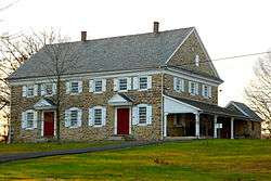 Buckingham Friends Meeting House, built 1768 | |
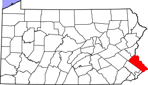
 Location of Buckingham Township in Bucks County | |
 Buckingham Township Location in Pennsylvania and the United States  Buckingham Township Buckingham Township (the United States) | |
| Coordinates: 40°22′33″N 75°04′59″W | |
| Country | United States |
| State | Pennsylvania |
| County | Bucks |
| Area | |
| • Total | 33.02 sq mi (85.5 km2) |
| • Land | 32.88 sq mi (85.2 km2) |
| • Water | 0.14 sq mi (0.4 km2) |
| Elevation | 364 ft (111 m) |
| Population (2010) | |
| • Total | 20,075 |
| • Estimate (2016)[2] | 20,306 |
| • Density | 610/sq mi (230/km2) |
| Time zone | UTC-5 (EST) |
| • Summer (DST) | UTC-4 (EDT) |
| Area code(s) | 215/267/445 |
| FIPS code | 42-017-09816 |
| Website | www |
History
In Buckingham and the Buckingham area, there are many important yet little known historical landmarks. One is Bogarts Tavern (now the General Greene Inn), on the corner of Route 413 (Durham Road) and Route 263 (Old York Road). It was from this building that General Nathanael Greene, commander of George Washington's left wing during the Battle of Trenton, made his headquarters during the winter of 1776.[3]
The Buckingham Friends Meeting House, Byecroft Farm Complex, Forest Grove Historic District, Thomas and Lydia Gilbert Farm, Holicong Village Historic District, Longland, Mechanicsville Village Historic District, Spring Valley Historic District, and Wycombe Village Historic District are listed on the National Register of Historic Places. The Buckingham Friends Meeting House is also designated a National Historic Landmark District.[4]
Mount Gilead A.M.E. Church was a station on the Underground Railroad.
Geography
According to the United States Census Bureau, the township has a total area of 33.1 square miles (86 km2), of which, 33.1 square miles (86 km2) of it is land and 0.04 square miles (0.10 km2) of it (0.06%) is water. It is drained by the Delaware River and its villages include Bridge Valley, Buckingham, Buckingham Valley, Forest Grove, Furlong (also in Doylestown Township,) Highton (also in Solebury Township,) Holicong, Lahaska (also in Solebury Township,) Mechanicsville, Mozart, Pineville (also in Wrightstown Township,) and Wycombe (also in Wrightstown Township.)
Buckingham Township is home to a gravity hill, on Buckingham Mountain near Mount Gilead African Methodist Episcopal Church.[5]
Past and present place names in Buckingham Township include Beckytown, Broad Axe, Buckingham, Clayton, Cross Keys, Forest Grove, Furlong, Glendale, Highlon, Holicong, Hollekonk, Lahaska, Landisville, Mechanicsville, Mozart, Pineville, Pools Corner, Spring Valley, and Wycombe.[6]
Natural features include Robin Run, Buckingham Cave, Buckingham Mountain, Curls Run, Dark Hollow, Flatiron Hill, Lahaska Creek, Lahaska Hill, Mill Creek, Neshaminy Creek, Paunacussing Creek, Pidcock Creek, Pine Run, and Watson Creek.[6]
Neighboring municipalities
- Solebury Township (northeast)
- Upper Makefield Township (east)
- Wrightstown Township (southeast)
- Warwick Township (south)
- Doylestown Township (southwest and west)
- Doylestown (west)
- Plumstead Township (northwest)
Demographics
| Historical population | |||
|---|---|---|---|
| Census | Pop. | %± | |
| 1930 | 2,213 | — | |
| 1940 | 2,359 | 6.6% | |
| 1950 | 3,007 | 27.5% | |
| 1960 | 4,018 | 33.6% | |
| 1970 | 5,150 | 28.2% | |
| 1980 | 8,839 | 71.6% | |
| 1990 | 9,364 | 5.9% | |
| 2000 | 16,442 | 75.6% | |
| 2010 | 20,075 | 22.1% | |
| Est. 2016 | 20,306 | [2] | 1.2% |
| [7] | |||
As of the 2010 census, the township was 93.8% White, 1.1% Black or African American, 0.1% Native American, 3.4% Asian, and 1.2% were two or more races. People of Hispanic or Latino ancestry accounted for 2.4% of the population.[8]
As of the census[9] of 2000, there were 16,442 people, 5,711 households, and 4,694 families residing in the township. The population density was 497.0 people per square mile (191.9/km²). There were 5,861 housing units at an average density of 177.2/sq mi (68.4/km²). The racial makeup of the township was 96.75% White, 1.04% African American, 0.12% Native American, 1.19% Asian, 0.01% Pacific Islander, 0.26% from other races, and 0.64% from two or more races. Hispanic or Latino of any race were 1.34% of the population.
There were 5,711 households, out of which 40.2% had children under the age of 18 living with them, 75.8% were married couples living together, 4.5% had a female householder with no husband present, and 17.8% were non-families. 14.3% of all households were made up of individuals, and 6.2% had someone living alone who was 65 years of age or older. The average household size was 2.85 and the average family size was 3.18.
In the township the population was spread out, with 28.3% under the age of 18, 4.1% from 18 to 24, 28.4% from 25 to 44, 25.9% from 45 to 64, and 13.3% who were 65 years of age or older. The median age was 40 years. For every 100 females there were 94.9 males. For every 100 females age 18 and over, there were 93.3 males.
The median income for a household in the township was $82,376, and the median income for a family was $90,968. Males had a median income of $71,649 versus $42,973 for females. The per capita income for the township was $35,735. About 2.4% of families and 4.1% of the population were below the poverty line, including 5.4% of those under age 18 and 2.3% of those age 65 or over.
Climate
According to the Köppen climate classification system, Buckingham Twp has a Hot-summer, Humid continental climate (Dfa). Dfa climates are characterized by at least one month having an average mean temperature ≤ 32.0 °F (0.0 °C), at least four months with an average mean temperature ≥ 50.0 °F (10.0 °C), at least one month with an average mean temperature ≥ 71.6 °F (22.0 °C) and no significant precipitation difference between seasons. Although most summer days are slightly humid in Buckingham Twp, episodes of heat and high humidity can occur with heat index values > 107 °F (42 °C). Since 1981, the highest air temperature was 102.6 °F (39.2 °C) on 07/22/2011, and the highest daily average mean dew point was 75.1 °F (23.9 °C) on 08/13/2016. The average wettest month is July which corresponds with the annual peak in thunderstorm activity. Since 1981, the wettest calendar day was 6.73 inches (171 mm) on 09/16/1999. During the winter months, the average annual extreme minimum air temperature is −1.4 °F (−18.6 °C).[10] Since 1981, the coldest air temperature was −12.5 °F (−24.7 °C) on 01/22/1984. Episodes of extreme cold and wind can occur with wind chill values < −12 °F (−24 °C). The average annual snowfall (Nov-Apr) is between 30 inches (76 cm) and 36 inches (91 cm). Ice storms and large snowstorms depositing ≥ 12 inches (30 cm) of snow occur once every few years, particularly during nor’easters from December through February.
| Climate data for Buckingham Twp, Elevation 253 ft (77 m), 1981-2010 normals, extremes 1981-2018 | |||||||||||||
|---|---|---|---|---|---|---|---|---|---|---|---|---|---|
| Month | Jan | Feb | Mar | Apr | May | Jun | Jul | Aug | Sep | Oct | Nov | Dec | Year |
| Record high °F (°C) | 70.7 (21.5) |
77.6 (25.3) |
87.0 (30.6) |
93.8 (34.3) |
94.6 (34.8) |
95.3 (35.2) |
102.6 (39.2) |
99.2 (37.3) |
97.3 (36.3) |
89.2 (31.8) |
80.3 (26.8) |
74.8 (23.8) |
102.6 (39.2) |
| Average high °F (°C) | 39.1 (3.9) |
42.5 (5.8) |
50.9 (10.5) |
62.9 (17.2) |
72.8 (22.7) |
81.6 (27.6) |
85.9 (29.9) |
84.1 (28.9) |
77.2 (25.1) |
65.9 (18.8) |
54.8 (12.7) |
43.4 (6.3) |
63.5 (17.5) |
| Daily mean °F (°C) | 30.5 (−0.8) |
33.3 (0.7) |
40.8 (4.9) |
51.6 (10.9) |
61.2 (16.2) |
70.5 (21.4) |
75.1 (23.9) |
73.5 (23.1) |
66.2 (19.0) |
54.6 (12.6) |
44.9 (7.2) |
35.0 (1.7) |
53.2 (11.8) |
| Average low °F (°C) | 21.8 (−5.7) |
24.0 (−4.4) |
30.7 (−0.7) |
40.3 (4.6) |
49.7 (9.8) |
59.4 (15.2) |
64.3 (17.9) |
62.8 (17.1) |
55.2 (12.9) |
43.3 (6.3) |
35.0 (1.7) |
26.6 (−3.0) |
42.8 (6.0) |
| Record low °F (°C) | −12.5 (−24.7) |
−4.5 (−20.3) |
1.8 (−16.8) |
16.6 (−8.6) |
33.0 (0.6) |
40.4 (4.7) |
46.9 (8.3) |
41.5 (5.3) |
34.0 (1.1) |
23.7 (−4.6) |
11.0 (−11.7) |
−2.4 (−19.1) |
−12.5 (−24.7) |
| Average precipitation inches (mm) | 3.32 (84) |
2.67 (68) |
3.85 (98) |
3.96 (101) |
4.34 (110) |
4.38 (111) |
5.07 (129) |
4.06 (103) |
4.45 (113) |
4.16 (106) |
3.67 (93) |
3.97 (101) |
47.90 (1,217) |
| Average relative humidity (%) | 66.6 | 63.1 | 58.8 | 57.8 | 62.3 | 67.2 | 67.2 | 69.7 | 70.9 | 69.7 | 68.6 | 68.6 | 65.9 |
| Average dew point °F (°C) | 20.7 (−6.3) |
22.1 (−5.5) |
27.5 (−2.5) |
37.2 (2.9) |
48.2 (9.0) |
59.1 (15.1) |
63.5 (17.5) |
63.0 (17.2) |
56.5 (13.6) |
44.9 (7.2) |
35.2 (1.8) |
25.7 (−3.5) |
42.1 (5.6) |
| Source: PRISM[11] | |||||||||||||
Ecology
According to the A. W. Kuchler U.S. potential natural vegetation types, Buckingham Twp would have a dominant vegetation type of Appalachian Oak (104) with a dominant vegetation form of Eastern Hardwood Forest (25).[12] The plant hardiness zone is 6b with an average annual extreme minimum air temperature of −1.4 °F (−18.6 °C).[10] The spring bloom typically begins by April 11th and fall color usually peaks by October 31st.
Notable residents
- Charles Skelton (1806–1879), represented New Jersey's 2nd congressional district in the United States House of Representatives from 1851 to 1855.[13]
- Steve Garvey, English punk band Buzzcocks bassist, 1993 through 1998.
- Michael Vick
References
- "2016 U.S. Gazetteer Files". United States Census Bureau. Retrieved Aug 13, 2017.
- "Population and Housing Unit Estimates". Retrieved June 9, 2017.
- Pierson, Susan. "Place Names in Buckingham Township". Buckingham Township Civic Association. Archived from the original on 2012-02-05. Retrieved 10 March 2012.
- "National Register Information System". National Register of Historic Places. National Park Service. July 9, 2010.
- http://weirdus.com/states/pennsylvania/roadside_oddities/gravity_hill/
- MacReynolds, George, Place Names in Bucks County, Pennsylvania, Doylestown, Bucks County Historical Society, Doylestown, PA, 1942
- "Archived copy". Archived from the original on 2019-04-09. Retrieved 2017-02-07.CS1 maint: archived copy as title (link)
- "Philadelphia gains, Pittsburgh shrinks in population". USA Today. Retrieved 10 March 2012.
- "U.S. Census website". United States Census Bureau. Retrieved 2008-01-31.
- "USDA Interactive Plant Hardiness Map". United States Department of Agriculture. Retrieved October 18, 2019.
- "PRISM Climate Group, Oregon State University". Retrieved October 18, 2019.
- "U.S. Potential Natural Vegetation, Original Kuchler Types, v2.0 (Spatially Adjusted to Correct Geometric Distortions)". Retrieved October 18, 2019.
- Charles Skelton, Biographical Directory of the United States Congress. Accessed August 25, 2007.
External links
| Wikimedia Commons has media related to Buckingham Township, Bucks County, Pennsylvania. |